Saskatchewan


This is a list of crossings of the South Saskatchewan River in the Canadian provinces of Saskatchewan and Alberta, from the river's confluence with the North Saskatchewan River at Saskatchewan River Forks, upstream to its origin at the confluence of the Bow and Oldman Rivers.

| Crossing | Carries | Location | Notes | Coordinates |
|---|---|---|---|---|
| Highway bridge | Highway 41 | south of Empress | 50°43′52″N110°04′08″W / 50.731°N 110.069°W | |
| Maple Avenue Bridge [15] | Altawana Drive NE to Maple Avenue | Medicine Hat | 50°02′42″N110°40′26″W / 50.045°N 110.674°W | |
| Railway bridge [16] | Canadian Pacific Railway | 50°02′38″N110°40′34″W / 50.044°N 110.676°W | ||
| Finlay Bridge [17] | 2nd Avenue NE to 6th Avenue SE | 50°02′35″N110°40′44″W / 50.043°N 110.679°W | ||
| Highway bridge [18] | Highway 1 | twin spans | 50°02′38″N110°43′08″W / 50.044°N 110.719°W | |
| Highway bridge | Highway 879 | northwest of Bow Island | 49°54′18″N111°28′37″W / 49.905°N 111.477°W |
The pipeline suspension bridge was erected in 1957 19 kilometres (12 mi) west of Burstall across the South Saskatchewan River. [19] [20]
The city of Medicine Hat hosted a public meeting proposing a Sanitary Sewer and Water Pipeline which is intended to cross the South Saskatchewan River. [21]

Medicine Hat is a city in southeast Alberta, Canada. It is located along the South Saskatchewan River. It is approximately 169 km (105 mi) east of Lethbridge and 295 km (183 mi) southeast of Calgary. This city and the adjacent Town of Redcliff to the northwest are within Cypress County. Medicine Hat was the sixth-largest city in Alberta in 2016 with a population of 63,230. It is also the sunniest place in Canada according to Environment and Climate Change Canada, averaging 2,544 hours of sunshine a year.

The Trans Canada Trail, officially named The Great Trail between September 2016 and June 2021, is a cross-Canada system of greenways, waterways, and roadways that stretches from the Atlantic to the Pacific to the Arctic oceans. The trail extends over 24,000 km (15,000 mi); it is now the longest recreational, multi-use trail network in the world. The idea for the trail began in 1992, shortly after the Canada 125 celebrations. Since then it has been supported by donations from individuals, corporations, foundations, and all levels of government.

The South Saskatchewan River is a major river in the Canadian provinces of Alberta and Saskatchewan. The river begins at the confluence of the Bow and Oldman Rivers in southern Alberta and ends at the Saskatchewan River Forks in central Saskatchewan. The Saskatchewan River Forks is the confluence of the South and North Saskatchewan Rivers and is the beginning of the Saskatchewan River.

Alberta Provincial Highway No. 3, commonly referred to as Highway 3 and officially named the Crowsnest Highway, is a 324-kilometre (201 mi) highway that traverses southern Alberta, Canada, running from the Crowsnest Pass through Lethbridge to the Trans-Canada Highway in Medicine Hat. Together with British Columbia Highway 3 which begins in Hope, it forms an interprovincial route that serves as an alternate to the Trans-Canada from the Lower Mainland to the Canadian Prairies.

Outlook is a town in west central Saskatchewan, Canada about 80 km south-southwest of Saskatoon. It is located along the South Saskatchewan River downstream from Gardiner Dam and the Coteau Creek Hydroelectric Station.
Alberta Provincial Highway No. 1, commonly referred to as Highway 1, is a major east–west highway in Southern Alberta that forms the southern mainline of the Trans-Canada Highway. It runs from the British Columbia border near Lake Louise through Calgary to the Saskatchewan border east of Medicine Hat. It continues as Highway 1 into both provinces. It spans approximately 534 km (332 mi) from Alberta's border with British Columbia in the west to its border with Saskatchewan in the east. The route is a divided 4-lane expressway throughout the province with the exception of a section in central Calgary where it is an arterial thoroughfare and Urban Boulevard carrying 4 to 6 lanes. The highway is a freeway between the Sunshine exit near the town of Banff and Home Road in Calgary. Other rural sections have at grade intersections with Interchanges only at busier junctions. Twinning of the final 8.5 km (5.3 mi) of Highway 1 between Lake Louise and the British Columbia border was completed by Parks Canada and opened to traffic on June 12, 2014 making the whole length of Alberta Highway 1 a divided minimum 4-lane route.
Saskatchewan Highway 7 is a major paved undivided provincial highway in the Canadian province of Saskatchewan, running from the Alberta border to Saskatoon. Highway 7 continues west into Alberta where it becomes Alberta Highway 9.
Highway 16 is a provincial highway in the Canadian province of Saskatchewan. It is the Saskatchewan section of the Yellowhead Highway, and also the Trans-Canada Highway Yellowhead section. The main purpose of this highway is to connect Saskatchewan with Canadian cities such as Edmonton and Winnipeg. The highway runs from the Alberta boundary in Lloydminster to the Manitoba boundary near Marchwell. Major cities it passes through are Saskatoon, North Battleford in the central part of the province, Yorkton in the far east and Lloydminster to the far west.

The Traffic Bridge is the name given to two truss bridges constructed across the South Saskatchewan River, connecting Victoria Avenue to 3rd Avenue South and Spadina Crescent in Saskatoon, Saskatchewan, Canada. The original bridge opened on October 10, 1907, and was the first bridge to carry motor vehicle traffic in Saskatoon, replacing an unreliable ferry service. The promised construction of the bridge was considered a prime factor in the amalgamation of the towns of Saskatoon, Nutana and Riversdale into one city named Saskatoon. The Traffic Bridge was the only road bridge in Saskatoon until 1916, when the University Bridge was completed. In 2010, the bridge was permanently closed due to severe corrosion and was demolished by 2016.

The North Saskatchewan River is a glacier-fed river that flows from the Canadian Rockies continental divide east to central Saskatchewan, where it joins with the South Saskatchewan River to make up the Saskatchewan River. Its water flows eventually into the Hudson Bay.
Highway 12 is a major highway in the Canadian province of Saskatchewan. It begins in Saskatoon at the intersection of Idylwyld Drive and Highway 11 north, initially running north on Idylwyld Drive concurrently with Highway 11 and Highway 16. Just outside Saskatoon's northern city limits, Highway 11 exits northeast from Idylwyld Drive and Highway 12 begins and travels north, passing through the city of Martensville. Highway 12 cross the North Saskatchewan River over Petrofka Bridge and passes through the town of Blaine Lake and intersects highway Highway 40, finally terminating at Highway 3 near Shell Lake. Highway 12 is about 135 km (84 mi) long.

Highway 35 is a paved undivided provincial highway in the Canadian province of Saskatchewan. It runs from the US Border near Port of Oungre to a dead end near the north shore of Tobin Lake. Saskatchewan Highway 35 (SK Hwy 35) is about 569 kilometres (354 mi) long. The CanAm Highway comprises Saskatchewan Highways 35, SK Hwy 39, SK Hwy 6, SK Hwy 3, SK Hwy 2 and U.S. Route 85. 74.6 kilometres (46.4 mi) of SK Hwy 35 contribute to the CanAm Highway between Port of Oungre on the Canada – United States border and Weyburn. Mudslides, and spring flooding were huge road building and maintenance problems around Nipawin as well as along the southern portion of the route named the Greater Yellow Grass Marsh. Over 20 early dams were built until the problem was addressed with the Rafferty-Alameda Project on the Souris River and the construction of the Qu'Appelle River Dam which have helped to eliminate washed out roads and flooded communities. The highway through the homesteading community followed the Dominion Land Survey on the square until reaching the Saskatchewan River at Nipawin. The completion of the combined railway and traffic bridge over the Saskatchewan River at Nipawin in the late 1920s retired the ferry and basket crossing for traffic north of Nipawin. The E.B. Campbell Dam built in 1963 northeast of Nipawin created Tobin Lake, and Codette Lake was formed with the construction of the Francois-Finlay Hydroelectric dam at Nipawin. The railway/traffic bridge that formed part of Highway 35 was the only crossing utilized at Nipawin until a new traffic bridge was constructed in 1974. The new bridge then became part of the combined Highway 35 and 55 until the highway parts just east of White Fox. Highway 35 then continued north along the west side of Tobin Lake. The railway/traffic bridge continues to be utilized for one lane vehicle traffic controlled by traffic lights, and continues as the "old highway 35" on the west side of the river until it joins with the current Highway 35/55.

The Central Business District is one of seven development districts in Saskatoon, Saskatchewan, Canada. The central business district is Ward 6 of a Mayor-Council government represented by councillor Cynthia Block. Formerly called West Saskatoon, this area arose when the steam engines built their pumping stations on the lower west bank of the South Saskatchewan River. Retail enterprises sprang up around the newly created train station and rail yards. The city of Saskatoon's Central Business District has shopping malls and boutiques.

Highway 41 is a highway in the Canadian province of Saskatchewan. It runs from Highway 5 in Saskatoon to Highway 3/Highway 6 in Melfort. Highway 41 is about 163 kilometres (101 mi) long.

The Red Coat Trail is a 1,300-kilometre (810 mi) route that approximates the path taken in 1874 by the North-West Mounted Police in their March West from Fort Dufferin to Fort Whoop-Up.
Transport in Saskatchewan includes an infrastructure system of roads, highways, freeways, airports, ferries, pipelines, trails, waterways, and railway systems serving a population of approximately 1,098,352 inhabitants year-round.

The CN Industrial Area is the industrial subdivision located in southern Saskatoon. It is also known as South Saskatoon, after the CN rail siding located in the area. It is a part of the Nutana Suburban Development Area. This industrial park was established with the Grand Trunk Pacific Railway crossing the South Saskatchewan River.

City of Medicine Hat was a paddle steamer sternwheeler that worked on the Saskatchewan River in Medicine Hat, Alberta, and Saskatchewan, Canada, from 1907 until its wreck and sinking on June 7, 1908.
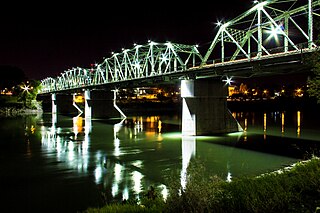
Finlay Bridge opened on May 14, 1908 in Medicine Hat, Alberta. Spanning 274 meters (900 ft) across the South Saskatchewan River, the traffic and pedestrian bridge connects Medicine Hat's north side to the south side. Upon completion it was largest steel bridge in Western Canada and is officially listed on the Alberta Register of Historic Places. It is named after William Thomas Finlay, a local politician who was the most vocal advocate for the bridge's construction.
{{citation}}: CS1 maint: multiple names: authors list (link)