Saskatoon is the largest city in the Canadian province of Saskatchewan. It straddles a bend in the South Saskatchewan River in the central region of the province. It is located along the Trans-Canada Yellowhead Highway, and has served as the cultural and economic hub of central Saskatchewan since its founding in 1882 as a Temperance colony.
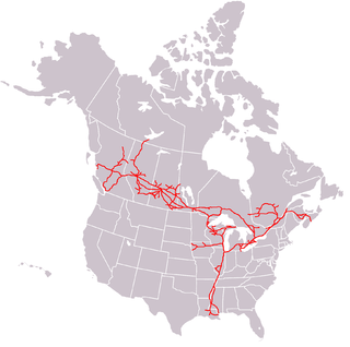
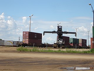
The Canadian National Railway Company is a Canadian Class I freight railway headquartered in Montreal, Quebec, which serves Canada and the Midwestern and Southern United States.

Prince Albert is the third-largest city in Saskatchewan, Canada, after Saskatoon and Regina. It is situated near the centre of the province on the banks of the North Saskatchewan River. The city is known as the "Gateway to the North" because it is the last major centre along the route to the resources of northern Saskatchewan. Prince Albert National Park is located 51 kilometres (32 mi) north of the city and contains a wealth of lakes, forest, and wildlife. The city itself is located in a transition zone between the aspen parkland and boreal forest biomes. Prince Albert is surrounded by the Rural Municipality of Prince Albert No. 461, of which it is the seat, but is politically separate.

Kitchener station is a railway station located in Kitchener, Ontario, Canada, slightly to the northeast of downtown Kitchener, at 126 Weber Street West, near the corner of Victoria Street. It is a heritage building containing a waiting room and ticket counter built beside a set of tracks also used as a freight yard. A separate building to the east of the passenger area, originally built in 1925 as a freight building, now serves as the headquarters for the Goderich–Exeter Railway.

The Traffic Bridge is the name given to two truss bridges constructed across the South Saskatchewan River, connecting Victoria Avenue to 3rd Avenue South and Spadina Crescent in Saskatoon, Saskatchewan, Canada. The original bridge opened on October 10, 1907, and was the first bridge to carry motor vehicle traffic in Saskatoon, replacing an unreliable ferry service. The promised construction of the bridge was considered a prime factor in the amalgamation of the towns of Saskatoon, Nutana and Riversdale into one city named Saskatoon. The Traffic Bridge was the only road bridge in Saskatoon until 1916, when the University Bridge was completed. In 2010, the bridge was permanently closed due to severe corrosion and was demolished by 2016.

Broadway Bridge is an arch bridge that spans the South Saskatchewan River in Saskatoon, Saskatchewan, Canada.

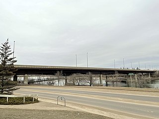
The Senator Sid Buckwold Bridge is a bridge that spans the South Saskatchewan River between west and east shore in Saskatoon, Saskatchewan, Canada. It was built in 1966, on the same site as the original Qu'Appelle, Long Lake and Saskatchewan bridge. The bridge is part of the Idylwyld Freeway, for which the former CNR Bridge was torn down. The act of dynamiting the original piers of the CNR Bridge became something of a spectacle as demolition experts were unable to completely destroy them. At the time, the new bridge cost $1.5 million to build.
Circle Drive Bridge spans the South Saskatchewan River in Saskatoon, Saskatchewan, Canada. It is a steel girder bridge, built in 1983 as part of the Circle Drive freeway system in northeast Saskatoon. At the time of construction, it cost $11.8 million to build. Between its opening in 1983 and the opening of the Chief Mistawasis Bridge in 2018, it was the northernmost vehicular river crossing in the city.

Warman (/ˈwɔrmən/) is the ninth-largest city in the province of Saskatchewan, Canada. It is located approximately 20 kilometres (12 mi) north of the city of Saskatoon, and 5 kilometres (3.1 mi) northeast of the city of Martensville. According to the 2021 census, Warman is the fastest growing municipality in Saskatchewan, and was the fastest growing municipality in Canada between 2011 and 2016. Warman is a bedroom community of Saskatoon. The current mayor is Gary Philipchuk.
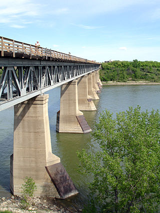
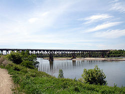
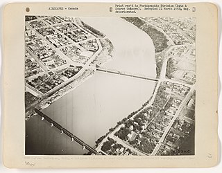
The CPR Bridge is a Canadian railway bridge that spans the South Saskatchewan River in Saskatoon, Saskatchewan.

Central Industrial is a light industrial area in Saskatoon, Saskatchewan, Canada, that comprises educational, recreational facilities, hotels and businesses along Idylwyld Drive. The community meets up with the Central Business District CBD to the west and south, and residential areas east and north.
The history of Saskatoon began with the first permanent non-indigenous settlement of Saskatoon, Saskatchewan, Canada, in 1883 when Toronto Methodists, wanting to escape the liquor trade in that city, decided to set up a "dry" community in the rapidly growing prairie region. As of 1882 this area was a part of the provisional district named Saskatchewan, North-West Territories (NWT). Their organization, the Temperance Colonization Society, first examined this area in 1882 and found that it would make an excellent location to found their community based on the ideals of the temperance movement; Saskatoon traditionally considers 1882 its founding year and thus marked its centennial in 1982. The settlers, led by John Neilson Lake, arrived on the site of what is now Saskatoon by traveling by railway from Ontario to Moose Jaw, Assiniboia, NWT, and then completing the final leg via horse-drawn cart. The plan for the Temperance Colony soon failed as the group was unable to obtain a large block of land within the community. Nonetheless, John Lake is commonly identified as the founder of Saskatoon; a public school, a park and two streets are named after him.

The Biggar station is a heritage railway station operated by Via Rail located in Biggar, Saskatchewan, Canada.

Circle Drive is a major road constructed as a ring road in Saskatoon, Saskatchewan, Canada. Its route constitutes both part of the Yellowhead Highway and Highway 11, signed as both along the entire length. It was first conceived in 1913 by the city commissioner and completed exactly 100 years later in 2013. Most of the route is a fully-controlled access freeway, however the segment between Airport Drive and Millar Avenue has at-grade intersections.
Transportation in Saskatchewan includes an infrastructure system of roads, highways, freeways, airports, ferries, pipelines, trails, waterways, and railway systems serving a population of approximately 1,132,505 inhabitants year-round.

The CN Industrial Area is the industrial subdivision located in southern Saskatoon. It is also known as South Saskatoon, after the CN rail siding located in the area. It is a part of the Nutana Suburban Development Area. This industrial park was established with the Grand Trunk Pacific Railway crossing the South Saskatchewan River.
The Canadian National Railway (C.N.) Yards Management Area located on Chappell Drive, Saskatoon, Saskatchewan consists of the VIA Saskatoon railway station and the train switching yards. These yards are a part of the Confederation Suburban Development Area (SDA). It lies (generally) north of the outskirts of the City and the Rural Municipality of Corman Park No. 344, west of Montgomery Place, south of 11th Street and east of Highway 7. Highway 7 has built an overpass over C.N. tracks where they intersect. This neighbourhood is not to be confused with the C.N. Industrial in the Nutana SDA on the east side of Saskatoon. These two sides of Saskatoon are connected with the Grand Trunk Bridge or CN railway bridge over the South Saskatchewan River.
The St. Louis Bridge is a closed Canadian traffic bridge that spans the South Saskatchewan River in St. Louis, Saskatchewan. It crosses the river from St. Louis into the Rural Municipality of Prince Albert No. 461.

City of Medicine Hat was a paddle steamer sternwheeler that worked on the Saskatchewan River in Medicine Hat, Alberta, and Saskatchewan, Canada, from 1907 until its wreck and sinking on June 7, 1908.