
Gordon Howe was a Canadian professional ice hockey player. From 1946 to 1980, he played 26 seasons in the National Hockey League (NHL) and six seasons in the World Hockey Association (WHA); his first 25 seasons were spent with the Detroit Red Wings. Nicknamed "Mr. Hockey", Howe is often considered the most complete player ever to play the game and one of the greatest of all time. At his retirement, his 801 goals, 1,049 assists, and 1,850 total points were all NHL records that stood until they were broken by Wayne Gretzky, who himself has been a major champion of Howe's legacy. A 23-time NHL All-Star, he shares the NHL record for seasons played with Chris Chelios, and his all-time NHL games played record of 1,767 was only surpassed in 2021 by Patrick Marleau. In 2017, Howe was named one of the "100 Greatest NHL Players".

SaskTel Centre is an arena located in Saskatoon, Saskatchewan, Canada. The facility opened in February 1988 and is currently the home venue of the Saskatoon Blades of the Western Hockey League, the Saskatchewan Rattlers of the Canadian Elite Basketball League, and the Saskatchewan Rush of the National Lacrosse League, with the arena being referred to as Co-op Field at SaskTel Centre during Rush games.

The Saskatoon Minor Football Field at Gordon Howe Park is a football stadium located in Saskatoon, Saskatchewan, Canada. It was opened September 30, 1960, built on land repossessed by the city in 1931 for unpaid taxes. It is the home of the Saskatoon Hilltops, who play in the Prairie Football Conference of the Canadian Junior Football League, the Saskatoon Valkyries of the Western Women's Canadian Football League, and is also used for high school football. It is located on the southwest corner of the city. The park is named after Gordie Howe, a Saskatoon native and member of the Hockey Hall of Fame.

The Traffic Bridge is the name given to two truss bridges constructed across the South Saskatchewan River, connecting Victoria Avenue to 3rd Avenue South and Spadina Crescent in Saskatoon, Saskatchewan, Canada. The original bridge opened on October 10, 1907, and was the first bridge to carry motor vehicle traffic in Saskatoon, replacing an unreliable ferry service. The promised construction of the bridge was considered a prime factor in the amalgamation of the towns of Saskatoon, Nutana and Riversdale into one city named Saskatoon. The Traffic Bridge was the only road bridge in Saskatoon until 1916, when the University Bridge was completed. In 2010, the bridge was permanently closed due to severe corrosion and was demolished by 2016.

The Senator Sid Buckwold Bridge is a bridge that spans the South Saskatchewan River between west and east shore in Saskatoon, Saskatchewan, Canada. It was built in 1966, on the same site as the original Qu'Appelle, Long Lake and Saskatchewan bridge. The bridge is part of the Idylwyld Freeway, for which the former CNR Bridge was torn down. The act of dynamiting the original piers of the CNR Bridge became something of a spectacle as demolition experts were unable to completely destroy them. At the time, the new bridge cost $1.5 million to build.
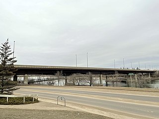
Circle Drive Bridge spans the South Saskatchewan River in Saskatoon, Saskatchewan, Canada. It is a steel girder bridge, built in 1983 as part of the Circle Drive freeway system in northeast Saskatoon. At the time of construction, it cost $11.8 million to build. Between its opening in 1983 and the opening of the Chief Mistawasis Bridge in 2018, it was the northernmost vehicular river crossing in the city.

Midtown is a shopping mall in Saskatoon, Saskatchewan, Canada, located in the Central Business District neighbourhood. The main anchor store is Hudson's Bay and the shopping centre has a total store count of 154 stores. The mall was built on the former site of the city's main railway station as part of a major inner city redevelopment project in the 1960s that also saw construction of a freeway, the Senator Sid Buckwold Bridge, TCU Place - an arts-convention complex - and a new facility for the city's YMCA.
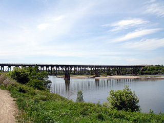
The Grand Trunk Bridge is a Canadian steel trestle railway bridge that spans the South Saskatchewan River in Saskatoon, Saskatchewan. It was built in 1908 as part of the Grand Trunk Pacific Railway project. The GTP was merged into the Canadian National Railway (CN) in 1920; as such, the structure is also referred to informally as the CN Railway Bridge.

The Mendel Art Gallery was a major creative cultural centre in City Park, Saskatoon, Saskatchewan. Operating from 1964 to 2015, it housed a permanent collection of more than 7,500 works of art. The gallery was managed by the city-owned Saskatoon Gallery and Conservatory Corporation, which also managed the Mendel's sister institution, the Saskatoon Civic Conservatory. In 1999, it was the 16th largest public art gallery in Canada by budget size and had the sixth highest overall attendance in the country. By 2010, it had more than 180,000 visitors.

Dundonald is a neighbourhood located in the northwest corner of Saskatoon, Saskatchewan. The neighbourhood was built in the 1980s, and served as the last development of the northwest corner of the city, prior to the development of Hampton Village. Dundonald is surrounded by a large landscaped park, with a storm pond. In comparison, the neighbourhood of Dundonald with a 2001 census population of 5,285 is larger than the Saskatchewan city of Melville which had a population of 4,149 in 2006, and 4,453 in 2001 and Dundonald is also larger than the provincial city of Humboldt which was 4,998 in 2006, and 5,161 in 2001. In Saskatchewan rural towns must maintain a population above 5,000 to apply for city status.

Rosewood is a primarily residential neighbourhood under construction in southeast Saskatoon, Saskatchewan, Canada. The majority of its residents live in single detached dwellings. In 2011, the area was home to 73 residents. In early 2015 there were approximately 900 occupied residences. The neighbourhood is considered a high-income area, with an average family income of $104,964, and a home ownership rate of 93.3%.

Stonebridge is a mostly residential neighbourhood located in south-central Saskatoon, Saskatchewan, Canada. It is a suburban subdivision, consisting of low-density, single detached dwellings and a mix of medium-density apartment and semi-detached dwellings. As of 2009, the area is home to 994 residents. The neighbourhood is considered a middle-income area, with an average family income of $67,642, an average dwelling value of $321,004 and a home ownership rate of 72.4%.

Willowgrove is a primarily residential neighbourhood located in the east side of Saskatoon, Saskatchewan, Canada. It comprises a mix of mainly single-family detached houses and fewer multiple-unit dwellings. As of 2011, the area is home to 3,973 residents. The neighbourhood is considered a middle to high-income area, with an average family income of $96,002, an average dwelling value of $218,357 and a home ownership rate of 84.8%.

Circle Drive is a major road constructed as a ring road in Saskatoon, Saskatchewan, Canada. Its route constitutes both part of the Yellowhead Highway and Highway 11, signed as both along the entire length. It was first conceived in 1913 by the city commissioner and completed exactly 100 years later in 2013. Most of the route is a fully-controlled access freeway, however the segment between Airport Drive and Millar Avenue has at-grade intersections.
River Heights is a neighbourhood in Lawson Suburban Development Area, Saskatoon, Saskatchewan. Its eastern boundary borders the South Saskatchewan River. The suburb is just south of the Mall at Lawson Heights. Development of the neighbourhood began in the very early 1960s, with full build out completed by the early 1980s. Most of the neighbourhood's land was annexed by the city in the late 1950s, with the eastern third of the district annexed in 1974. As a community name, River Heights predates the development by half a century, appearing on the May 1912 "Saskatoon and Environs" map that sketched out future development for the young city; at the time, the name was attached to a community in the current location of Montgomery Place.

The CN Industrial Area is the industrial subdivision located in southern Saskatoon. It is also known as South Saskatoon, after the CN rail siding located in the area. It is a part of the Nutana Suburban Development Area. This industrial park was established with the Grand Trunk Pacific Railway crossing the South Saskatchewan River.

South West Industrial, also known as Holiday Park Industrial and labelled SEDCO Industrial on city maps of the 1980s and 1990s, is an industrial subdivision located in the Confederation SDA in southwest Saskatoon, Saskatchewan, Canada.
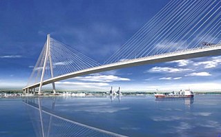
The Gordie Howe International Bridge, known during development as the Detroit River International Crossing and the New International Trade Crossing, is a cable-stayed international bridge across the Detroit River, currently under construction. The crossing will connect Detroit, Michigan, United States of America, and Windsor, Ontario, Canada, by linking Interstate 75 in Michigan with Highway 401 in Ontario. The bridge will provide uninterrupted freeway traffic flow, as opposed to the current configuration with the nearby Ambassador Bridge that connects to city streets on the Ontario side. The bridge is named after Canadian ice hockey player Gordie Howe, whose celebrated career included 25 years with the Detroit Red Wings, and who died two years before construction began.
Yorath Island is a small island, 151 acres (61 ha) in size, in the South Saskatchewan River just outside the southern boundaries of the city of Saskatoon, Saskatchewan, Canada. The island is relatively new, and did not exist when the land was first surveyed in 1903. This island is managed by the Meewasin Valley Authority; it is not accessible by road, but can be seen from the Maple Grove area. The island is named after Christopher J. Yorath, who in 1913 became the commissioner of Saskatoon. Yorath is best known for an extensive, forward-thinking planning document published in 1913 that proposed future residential and road layout for Saskatoon, and he originated the idea of the City developing an "Encircling Boulevard"; in 2013 this proposal came to fruition with the completion of the Circle Drive freeway project. Ironically, Yorath's document proposed the Encircling Boulevard cross through what would later be named Yorath Island; the final Circle Drive passes to the north of the island, which is undeveloped save for a set of power lines that cross the river at the northern tip of the island.

Ice hockey is among the most popular sports in the Canadian province of Saskatchewan, and the province has been notable for producing a large number of hockey figures in both men's and women's hockey. Saskatchewan does not currently have a professional hockey team of its own, but it is home to a large number of junior and senior hockey teams. The sport is governed in the province by Hockey Saskatchewan.

