Valsad, historically known as Bulsar, is a city and a municipality in Valsad district of the Indian state of Gujarat. It is the district headquarters of Valsad district. Valsad is located south of Navsari and shares border with Maharashtra and the union territories of Dadra and Nagar Haveli and Daman and Diu in the south.

Navsari is an administrative district in the state of Gujarat in India, with its headquarters at the city of Navsari. The district covers an area of 2,211 square kilometres and was formed in 1997 after Valsad district was split into Valsad and Navsari districts. It is the largest producer of chikoos in India.
Navsari is the ninth biggest city in the state of Gujarat in India. It is the administrative headquarters of Navsari District. Navsari is situated between Surat & Mumbai. Navsari is a twin city of Surat. It is located 37 km south of Surat. As per 2011 Census of India, Navsari is 16th biggest city of Gujarat state. It ranked 10th most populous city of Gujarat in 1991 Census of India and 2001 Census of India. Navsari is the 25th cleanest city of India according to the Swachh Bharat Urban mission. Dandi village near Navsari was the focal point of the great Salt March led by Mahatma Gandhi during civil disobedience movement of India.

Valsad district is one of the 33 districts in the Western Indian state of Gujarat. It is bound by Navsari district to the north, Nashik district of Maharashtra state to the east, and Dadra and Nagar Haveli district of the Dadra and Nagar Haveli and Daman and Diu (DNHDD) union territory and the Palghar district of Maharashtra to the south. The Arabian Sea lies west of the district. The coastal Daman enclave of DNHDD is bounded by Valsad district on the north, east, and south. The district's administrative capital is Valsad. The district's largest city is Vapi.

Vansda, also known as Bansda, is a city and a municipality in the Navsari district in the Indian State of Gujarat, covering an area of 557 km2.
Bilimora is a city situated on the banks of the river Ambika, in Gandevi taluka & Navsari district of Gujarat state, in India. The city comes under the purview of the Surat Metropolitan Region. The city is roughly 70 kilometres (43 mi) south of the city of Surat and is the southernmost point of the Surat Metropolitan Region and the Metropolis of Surat. It is linked to Surat by SH 6 and SH 88.
Sachin is area and Surat Municipal corporation in the Surat Metropolitan Region in the Indian state of Gujarat. The town has a large industrial area managed by Gujarat Industrial Development Corporation (GIDC), SurSEZ, Diamond SEZ and many other private SEZs, In Land Container Depot (ICD) is located in Sachin.

Jogwad is a village in the state of Gujarat in western India. It lies near to Indian National Highway 8, about 12 kilometres and is about 260 kilometres (160 mi) from Mumbai, 35 kilometres (22 mi) from Navsari and about 100 kilometres (62 mi) from Saputra hill station.
Dhanori is a small village in Navsari district in the state of Gujarat, India. It is about 40 kilometres (25 mi) north of the city of Valsad and about 25 kilometres (16 mi) south of the district city of Navsari.
Nandarkha is a village situated in the Navsari district of the Indian state of Gujarat. It is positioned in the southwestern region of the Navsari district, lying between the towns of Bilimora and Chikhli.
Manekpore - Rethvania is a village in the state of Gujarat in western India off Indian National Highway 8 pincode IS 396560 on Vansda Road from where you can travel to ahwa, via waghai, and vansda, and to the hill station of Saputara.
Alipor is a village near Chikhli, Bilimora in the state of Gujarat in western India. The village is on the Indian National Highway 8, which leads to areas such as Ahwa via Waghai and Vansda, and to the hill station of Saputara.

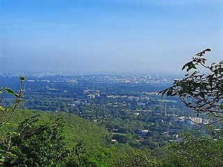
South Gujarat, also known as Dakshin Gujarat, is a region in the Indian state of Gujarat. The region has a wetter climate than other regions of Gujarat. The western part is almost coastal and is known as Kantha Vistar, and the eastern part is also known as Dungar Vistar, which ranges from 100 to 1000 metres, with the highest peak at Saputara in the Dang district.

The geography of Gujarat state of India includes following:

Wilson Hills is a hill station in the Indian state of Gujarat. It is near Dharampur Taluka and is also the nearest hill station to valsad Surat.
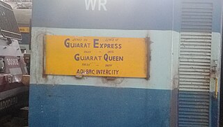
The 19033 / 19034 Gujarat Queen is an Express train belonging to Indian Railways that run between Valsad and Ahmedabad Junction in India. It operates as train number 19033 from Valsad to Ahmedabad Junction and as train number 19034 in the reverse direction.
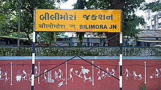
Bilimora Junction railway station is a small railway station in Navsari district, Gujarat, India. Its code is BIM. It serves the city of Bilimora. The station consists of five platforms. The platforms are not well sheltered. It lacks many facilities including water and sanitation. Passenger, Express and Superfast trains halt here.

The 12929 / 12930 Valsad–Vadodara Intercity Superfast Express is a Superfast Express train of the Indian Railways connecting Valsad and Vadodara of Gujarat. It is currently being operated with 12929/12930 train numbers on a daily basis.

Unai is a village in the Navsari district in the Indian State of Gujarat, India. Unai is connected with Waghai, Chikhli, Saputara, Nasik, Vapi, Dharampur, Shamlaji by state highway. This village situated on Billimora–Waghai narrow gauge railway route. The nearest railway station for broad gauge trains is Bilimora Junction.
The 69151/69152 Valsad–Surat MEMU is a MEMU train of the Indian Railways connecting Valsad and Surat of Gujarat. It is currently being operated with 69151/69152 train numbers on a daily basis.


