Radar is a detection system that uses radio waves to determine the distance (ranging), angle, and radial velocity of objects relative to the site. It can be used to detect aircraft, ships, spacecraft, guided missiles, motor vehicles, weather formations, and terrain. A radar system consists of a transmitter producing electromagnetic waves in the radio or microwaves domain, a transmitting antenna, a receiving antenna and a receiver and processor to determine properties of the object(s). Radio waves from the transmitter reflect off the object and return to the receiver, giving information about the object's location and speed.

Lidar is a method for determining ranges by targeting an object or a surface with a laser and measuring the time for the reflected light to return to the receiver. It can also be used to make digital 3-D representations of areas on the earth's surface and ocean bottom by varying the wavelength of light. It has terrestrial, airborne, and mobile applications.

Millimeter-wave cloud radars, also denominated cloud radars, are radar systems designed to monitor clouds with operating frequencies between 24 and 110 GHz. Accordingly, their wavelengths range from 1 mm to 1.11 cm, about ten times shorter than those used in conventional S band radars such as NEXRAD.

The NASA Deep Space Network (DSN) is a worldwide network of American spacecraft communication ground segment facilities, located in the United States (California), Spain (Madrid), and Australia (Canberra), that supports NASA's interplanetary spacecraft missions. It also performs radio and radar astronomy observations for the exploration of the Solar System and the universe, and supports selected Earth-orbiting missions. DSN is part of the NASA Jet Propulsion Laboratory (JPL).

A radar speed gun is a device used to measure the speed of moving objects. It is used in law-enforcement to measure the speed of moving vehicles and is often used in professional spectator sport, for things such as the measurement of bowling speeds in cricket, speed of pitched baseballs, and speed of tennis serves.

Electromagnetic interference (EMI), also called radio-frequency interference (RFI) when in the radio frequency spectrum, is a disturbance generated by an external source that affects an electrical circuit by electromagnetic induction, electrostatic coupling, or conduction. The disturbance may degrade the performance of the circuit or even stop it from functioning. In the case of a data path, these effects can range from an increase in error rate to a total loss of the data. Both man-made and natural sources generate changing electrical currents and voltages that can cause EMI: ignition systems, cellular network of mobile phones, lightning, solar flares, and auroras. EMI frequently affects AM radios. It can also affect mobile phones, FM radios, and televisions, as well as observations for radio astronomy and atmospheric science.

Imaging radar is an application of radar which is used to create two-dimensional images, typically of landscapes. Imaging radar provides its light to illuminate an area on the ground and take a picture at radio wavelengths. It uses an antenna and digital computer storage to record its images. In a radar image, one can see only the energy that was reflected back towards the radar antenna. The radar moves along a flight path and the area illuminated by the radar, or footprint, is moved along the surface in a swath, building the image as it does so.
Earth–Moon–Earth communication (EME), also known as Moon bounce, is a radio communications technique that relies on the propagation of radio waves from an Earth-based transmitter directed via reflection from the surface of the Moon back to an Earth-based receiver.
A pulse-Doppler radar is a radar system that determines the range to a target using pulse-timing techniques, and uses the Doppler effect of the returned signal to determine the target object's velocity. It combines the features of pulse radars and continuous-wave radars, which were formerly separate due to the complexity of the electronics.

The Low-Frequency Array, or LOFAR, is a large radio telescope network located mainly in the Netherlands, completed in 2012 by ASTRON, the Netherlands Institute for Radio Astronomy and its international partners, and operated by ASTRON's radio observatory, of the Netherlands Organisation for Scientific Research.
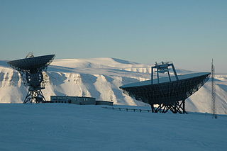
EISCAT operates three incoherent scatter radar systems, at 224 MHz, 931 MHz in Northern Scandinavia and one at 500 MHz on Svalbard, used to study the interaction between the Sun and the Earth as revealed by disturbances in the ionosphere and magnetosphere. At the Ramfjordmoen facility, it also operates an ionospheric heater facility, similar to HAARP. Additional receiver stations are located in Sodankylä, Finland, and Kiruna, Sweden. The EISCAT Svalbard radar (ESR) is located in Longyearbyen, Norway. The EISCAT Headquarters are also located in Kiruna.
GIOVE, or Galileo In-Orbit Validation Element, is the name for two satellites built for the European Space Agency (ESA) to test technology in orbit for the Galileo positioning system.
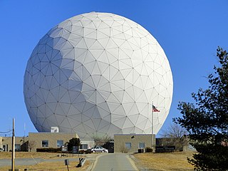
Haystack Observatory is a multidisciplinary radio science center, ionospheric observatory, and astronomical microwave observatory owned by Massachusetts Institute of Technology (MIT). It is located in Westford, Massachusetts (US), approximately 45 kilometers (28 mi) northwest of Boston. Haystack was initially built by MIT's Lincoln Laboratory for the United States Air Force and was known as Haystack Microwave Research Facility. Construction began in 1960, and the antenna began operating in 1964. In 1970 the facility was transferred to MIT, which then formed the Northeast Radio Observatory Corporation (NEROC) with a number of other universities to operate the site as the Haystack Observatory. As of January 2012, a total of nine institutions participated in NEROC.
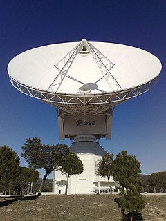
Cebreros Station is a European Space Agency, ESTRACK radio antenna station for communication with spacecraft, located about 10 km east of Cebreros and 90 km from Madrid, Spain, operated by the European Space Operations Centre and INTA. A 35-metre diameter antenna that receives and transmit in X- and Ka-bands is located at the site. Station code is "CEB". 20kW CW High Power Amplifier (HPA) it was created by Rheinmetall Italia SpA (Italy). The monitoring and control system was implemented by Microsis srl (Italy).

The Medicina Radio Observatory is an astronomical observatory located 30 km from Bologna, Italy. It is operated by the Institute for Radio Astronomy of the National Institute for Astrophysics (INAF) of the government of Italy.

Radio is the technology of signaling and communicating using radio waves. Radio waves are electromagnetic waves of frequency between 30 hertz (Hz) and 300 gigahertz (GHz). They are generated by an electronic device called a transmitter connected to an antenna which radiates the waves, and received by another antenna connected to a radio receiver. Radio is very widely used in modern technology, in radio communication, radar, radio navigation, remote control, remote sensing, and other applications.

EarthCARE is a planned joint European/Japanese satellite, the sixth of ESA's Earth Explorer Programme. The main goal of the mission is the observation and characterization of clouds and aerosols as well as measuring the reflected solar radiation and the infrared radiation emitted from Earth's surface and atmosphere.
The Kilpisjärvi Atmospheric Imaging Receiver Array (KAIRA) is an astronomical observatory operated by the Sodankylä Geophysical Observatory on behalf of Oulu University. It is located at Kilpisjärvi, Enontekiö near the border with Norway. It comprises two LOFAR-derived radio telescope systems and is capable of observing at HF and VHF radio frequencies. It is used for atmospheric, near-Earth space and astronomical research. KAIRA uses LOFAR phased-array antennas and digital signal-processing hardware. The phased array configuration has no moving parts and with digital control, allows KAIRA to quickly scan the sky, giving KAIRA a large field of view. KAIRA can produce a continuous all-sky image of the radio transparency of ionosphere, using cosmic radio noise for "illumination" (riometry). KAIRA can also obtain electron density profiles in the atmosphere. This allows the study of the interaction of the solar wind with the atmosphere, such as in aurora borealis and other space weather phenomena. In addition to near-space imaging, the use of KAIRA has been demonstrated for long-baseline interferometry observations of pulsars.
The Space Situational Awareness (SSA) Programme is the European Space Agency's (ESA) initiative designed to support Europe's independent space access and utilization through the timely and accurate information delivery regarding the space environment, and particularly hazards to both in orbit and ground infrastructure. The SSA programme is split into three main segments:
BIOMASS is an Earth observing satellite planned for launch by the European Space Agency (ESA) in August 2023 on a Vega launch vehicle.