Sequoia National Park is an American national park in the southern Sierra Nevada east of Visalia, California. The park was established on September 25, 1890, and today protects 404,064 acres of forested mountainous terrain. Encompassing a vertical relief of nearly 13,000 feet (4,000 m), the park contains the highest point in the contiguous United States, Mount Whitney, at 14,505 feet (4,421 m) above sea level. The park is south of, and contiguous with, Kings Canyon National Park; both parks are administered by the National Park Service together as Sequoia and Kings Canyon National Parks. UNESCO designated the areas as Sequoia-Kings Canyon Biosphere Reserve in 1976.

The Bitterroot Range is a mountain range and a subrange of the Rocky Mountains that runs along the border of Montana and Idaho in the northwestern United States. The range spans an area of 24,223 square miles (62,740 km2) and is named after the bitterroot, a small pink flower that is the state flower of Montana.

A hoodoo is a tall, thin spire of rock formed by erosion. Hoodoos typically consist of relatively soft rock topped by harder, less easily eroded stone that protects each column from the elements. They generally form within sedimentary rock and volcanic rock formations.
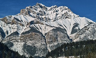
Cascade Mountain is a mountain located in the Bow River Valley of Banff National Park, adjacent to the town of Banff. The mountain was named in 1858 by James Hector after the waterfall or cascade on the southern flanks of the peak. The mountain has also been called Stoney Chief, which is related to the name of the smaller neighbouring mountain Stoney Squaw, which is still in use. Cascade is the highest mountain adjacent to the townsite.

Mount Ball is a mountain located on the Continental Divide, on the borders of Banff and Kootenay national parks in Western Canada. Mt. Ball is the highest peak of the Ball Range in the Canadian Rockies.
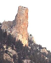
Chimney Rock can refer to one of the following sites in the United States and Canada:

The Clear Range is a small mountain range located in the angle of the Fraser and Thompson Rivers in south-central British Columbia, Canada. It has a small subdivision just northeast of that confluence named the Scarped Range. The Clear Range totals 16,270 km2 (6,280 sq mi) and is 75 km (47 mi) north to south and 35 km (22 mi) east to west. The Clear Range and its northward neighbour the Marble Range are both subranges of the Pavilion Range.

Marble Canyon is in the south-central Interior of British Columbia, a few kilometres east of the Fraser River and the community of Pavilion, midway between the towns of Lillooet and Cache Creek. The canyon stems from a collapsed karst formation.

The Black Tusk, known as Q̓elqámtensa ti Skenknápa in the St'at'imcets (Lillooet) language and as T'ákt'akmúten tl'a Ín7inyáx̱a7en in the Sḵwx̱wú7mesh (Squamish) language, is a stratovolcano and a pinnacle of volcanic rock in Garibaldi Provincial Park of British Columbia, Canada. At 2,319 m (7,608 ft) above sea level, the upper spire is visible from a great distance in all directions. It is particularly noticeable from the Sea-to-Sky Highway just south of Whistler, British Columbia. Distinctive and immediately identifiable, The Black Tusk is among the best known mountains in the Garibaldi Ranges of the Coast Mountains. The volcano is part of the Garibaldi Volcanic Belt which is a segment of the Canadian Cascade Arc, but it is not within the geographic boundary of the Cascade Range.

Marble Canyon Provincial Park is a provincial park in British Columbia, Canada, established in 1956 to protect Marble Canyon, a limestone formation at the south end of the Marble Range. In 2001 the park was expanded to 355 hectares to include all of Pavilion Lake due to the presence of microbialites, a type of stromatolite important to research into astrobiology and other fields, and in 2010, it was further expanded to 2,544 hectares.
Chimney Rock National Monument is a 4,726-acre (1,913 ha) U.S. National Monument in San Juan National Forest in southwestern Colorado which includes an archaeological site. This area is located in Archuleta County, Colorado, between Durango and Pagosa Springs, and is managed for archaeological protection, public interpretation, and education. The Chimney Rock Archaeological Site has been listed on the National Register of Historic Places since 1970. U.S. President Barack Obama created Chimney Rock National Monument by proclamation on September 21, 2012, under authority of the Antiquities Act.

Bivouac Peak is in the northern Teton Range, Grand Teton National Park, Wyoming. The peak is located immediately to the west of Moran Bay on Jackson Lake, and rises more than 4,000 ft (1,200 m) in less than 0.5 mi (0.80 km) from the lakeshore. Moran Canyon is situated to the south of the mountain and Snowshoe Canyon lies to the north.

Traverse Peak is in the northern Teton Range, Grand Teton National Park, Wyoming. The mountain rises abruptly above Moran Canyon to the south and the south fork of Snowshoe Canyon to the north. From Moran Bay on Jackson Lake, the south slopes of the mountain can be seen behind Bivouac Peak rising above Moran Canyon.

Pavilion Lake is a freshwater lake located in Marble Canyon, British Columbia, Canada home to colonies of freshwater microbialites.
Pavilion Mountain is the highest summit of the southern Marble Range in the South Cariboo region of southwestern British Columbia. "Mount Carson", a subsidiary peak, was misapplied to the whole mountain 1957–1965, before the well-established local name was restored. Pavilion Creek is to the south. Pavilion Lake and Marble Canyon are to the southeast.

A balancing rock, also called a balanced rock or precarious boulder, is a naturally occurring geological formation featuring a large rock or boulder, sometimes of substantial size, resting on other rocks, bedrock, or on glacial till. Some formations known by this name only appear to be balancing, but are in fact firmly connected to a base rock by a pedestal or stem.

Forest Falls is an unincorporated community in San Bernardino County, California, 75 miles (121 km) due east of Los Angeles. The community has a population of 1,102 and contains 712 houses. Forest Falls is best known for the waterfalls on Vivian and Falls creeks and as a point of access for recreation in the San Bernardino National Forest, particularly the San Gorgonio Wilderness Area, which lies directly north of the community.
The Marble Canyon Dam, also known as the Redwall Dam, was a proposed dam on the Colorado River in Arizona, United States. The dam was intended to impound a relatively small reservoir in the central portion of Marble Canyon to develop hydroelectric power. Plans centered on two sites between miles 30 and 40 in the canyon. At one point a 38-mile (61 km) tunnel was proposed to a site just outside Grand Canyon National Park to develop the site's full power generation potential, reducing the Colorado River to a trickle through the park.