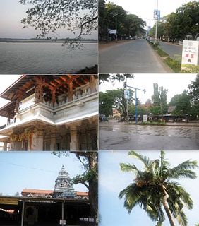
Kundapur, also called Kundapura, is a coastal town situated in the Udupi district of the state of Karnataka, India. This town was known as Coondapoor while it was part of the erstwhile South Canara district (1862–1947) of the Madras Presidency of British India. Present-day Kundapur is administered by the Kundapur Town Municipal Council and serves as the headquarters of the Kundapur Taluk of Udupi district.

Thane district is a district in the Konkan Division of Maharashtra, India. At the 2011 Census it was the most populated district in the country, with 11,060,148 inhabitants; however, in August 2014 the district was split into two with the creation of a new Palghar district, leaving the reduced Thane district with a 2011 Census population of 8,070,032. The headquarters of the district is the city of Thane. Other major cities in the district are Navi Mumbai, Kalyan-Dombivli, Mira-Bhayander, Bhiwandi, Ulhasnagar, Ambarnath, Badlapur, Murbad and Shahapur.
Palghar is a town in the Konkan division of Maharashtra state, India and a municipal council. It is in the Mumbai Metropolitan Region, and since 2014 it has been the administrative capital of the Palghar district. Palghar lies on the Western Line of the Mumbai Suburban Railway in the busy Mumbai-Ahmedabad rail corridor. The town is located about 87 kilometers north of Mumbai, about 35 kilometers north of Virar and about 24 kilometers west of the Mumbai-Ahmedabad National Highway at Manor.

Navsari is an administrative district in the state of Gujarat in India, with its headquarters at the city of Navsari. The district covers an area of 2,211 square kilometres and was formed in 1997 after Valsad district was split into Valsad and Navsari districts. The city picked up a greater pace commercially during the diamond polishing business soared in the region.
Kudal is a census town in Sindhudurg district, Maharashtra, India. It is situated on Karli River in southwest Maharashtara. Kudal is the fourth largest town in Sindhudurg after Sawantwadi, Malvan and Kankavli. As of 2011, the population is 16,015. Kudal supports one MIDC area. Kudal railway station is located on the Konkan Railway route and connects the town with Mumbai on the north and Mangalore on the south. It is a major stop for the Konkan Railway with many trains having a halt. The Deccan Odyssey train also stops in Kudal. National Highway 66 passes through Kudal. Apart from that, it also has two bus stations, a new one and old one. The old one is situated in market while the new one is just adjacent to the NH-66. Kudal is situated in centre of the Sindhudurg district and also considered one of the fastest-growing towns in the region.
Tarapur is a census town in Palghar district in the Indian state of Maharashtra. It is an industrial town located some 45 km north of Virar, on the Western

Dahanu is a coastal town and a municipal council in Palghar district of Maharashtra state in Konkan division. It is located 110 km from Mumbai city and hosts Adani Power’s thermal power station. It is the site of the currently stalled Wadhawan port project at Rewas.
Vangaon is a village in the Palghar district of Maharashtra, India. It is located in the Dahanu taluka.
Kelwa or Kelve is a town in Maharashtra, India. It is served by the Kelve Road railway station on the Western line of the Mumbai Suburban Railway which extends from Churchgate to Dahanu Road.
Dahegam is a city and a municipality in Gandhinagar district in the state of Gujarat, India.
Manor is a census town in Palghar district in the Indian state of Maharashtra. It is located 88 km north of Mumbai on the Mumbai-Ahmedabad National Highway (NH8) and also connects with Nashik via the Manor-Wada Road.
Narkhed is a town and a municipal council in Nagpur district in the Indian state of Maharashtra. It is about 87 km north-west of Nagpur. It is the administrative headquarters of Narkhed taluka, one of the 14 talukas of this district. It is located in the "orange belt" and is a major center for orange-trading.

Talaja is a town and a municipality in Bhavnagar district in the Indian state of Gujarat.
Peth or Peint is the smallest tehsil of Nashik subdivision of Nashik district in Maharashtra, India. It belongs to Northern Maharashtra region. It belongs to Nashik Division. Peth is a Taluka headquarter. It is located 54 km to the West of Nashik District headquarters. It is also called as Peint. Pin code of Peth is 422208 and postal head office is Peth.
Joida is a town located in the Uttar Kannada district in the Indian state of Karnataka. The town is the headquarters of the eponymous taluk. Earlier it was known as Supa taluku but as Supa village got submerged due to dam built across river Kali,Joida taluka came into existence.
Boisar is the largest industrial suburb in the Mumbai Metropolitan Region in the Indian state of Maharashtra. It was originally a part of the Thane district before becoming a part of the Palghar district. It is approximately 111 kilometers away from the state capital Mumbai, and is 98 km (61 mi) from the union territory Daman. It is located in the district Palghar.

Palghar District is a district in the state of Maharashtra in Konkan Division.
New Manor Town is an affordable housing project in the town of Manor, India. The housing complex is in close proximity to the industrial towns of Palghar and Boisar.
Dhakti Dahanu is a village in the Palghar district of Maharashtra, India. It is located in the Dahanu taluka, on the shore of Arabian Sea.Located just other side of the Dahanu khadi from the town, it is connected with Dahanu by bridge over the creek.

