
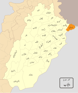
The administrative units of Pakistan consist of four provinces, two autonomous territories and one federal territory. Each province and territory is subdivided into divisions, which are further subdivided into districts, which are further subdivided into tehsils, or taluka, which are further subdivided into union councils.
Jhang District is a district of the Punjab province of Pakistan. The city of Jhang is the district's capital. In 2009 the tehsil of Chiniot became the separate Chiniot District.

Nasirabad is a district in the centre-west of Balochistan, Pakistan. Nasirabad's headquarters are at Dera Murad Jamali.

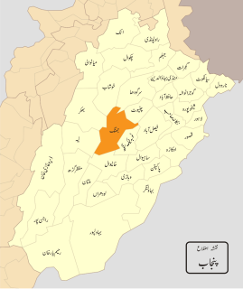
Khushab District is a district in the province of Punjab, Pakistan, with its administrative capital in Jauharabad. The district is named after the historical city of Khushab located within its boundaries. According to the 1998 census, the population was 905,711 with 24.76% living in urban areas. The district consists of four tehsils, Khushab, Noorpur Thal, Quaidabad and Naushera. Khushab is home to the Heavy Water and Natural Uranium Research Reactor, part of the Pakistan's Special Weapons Program.

Attock District is a district in Pothohar Plateau of the Punjab Province of Pakistan. Attock is the capital of the district.

Chakwal is the capital and main city of Chakwal District, Punjab, Pakistan. It is located 90 kilometres south-east of the federal capital, Islamabad and 270 kilometres from the provincial capital, Lahore.

Sargodha District, is a district of Punjab, Pakistan. The capital of the district is Sargodha. It is an agricultural district, wheat, rice, and sugarcane being its main crops. The Sargodha district and region is also famous for citrus fruit including Kinnow, orange and lemon. The district has an area of 5,864 km2.

Dera Ghazi Khan is a district in the Punjab province of Pakistan. Its capital is Dera Ghazi Khan city.
Mandi Bahauddin, also spelled Mandi Baha ud Din, is a district in the Punjab province of Pakistan. It is bordered on the northwest by the Jhelum River, on the southeast by the Chenab River, and on the southwest by the Sargodha District. The district has an area of 2,673 square kilometres (1,032 sq mi). Mandi district currently has 1.5 million population.

Sialkot District, is one of the districts of the Punjab provinces of Pakistan. It is located in the north-east of the province. The city of Sialkot is the capital of the district. It is the third-richest city in Pakistan. The Sialkot cantonment was established in 1852.
Lower Dir District is a district in Malakand Division of Khyber Pakhtunkhwa province in Pakistan. Timergara city is the district headquarters and largest city, while the second largest city is Chakdara.

Bhakkar District, is a district in the province of Punjab, Pakistan. The district was created out of parts of Mianwali in 1982 with Bhakkar city as the headquarter and main city. Its area consists of a riverine tract along the Indus, called Kaccha, and most of the district area lies in the desolate plain of the Thal desert.
{{Infobox settlement | official_name = | name = Lodhran District | native_name = ضِلع لودھراں | native_name_lang = | settlement_type = District | image_skyline = | imagesize = | image_alt = | image_caption = | image_map = Punjab Dist Lodharan.svg | mapsize = 200px | map_alt = | map_caption = Map of Punjab with Lodhran District highlighted | latd = |latm = |lats = |latNS = | longd = |longm = |longs = |longEW = | coordinates_type = | coordinates_display = | subdivision_type = Country | subdivision_name = Pakistan | subdivision_type1 = Province | subdivision_name1 = Punjab | founder = | seat_type = Headquarters | seat = Lodhran city | government_footnotes = | leader_party = | unit_pref = Metric | area_footnotes = | area_total_km2 = 1790 | population_footnotes = | population_as_of = 2017 | population_total = 1,700,620 | population_density_km2 = auto | timezone1 = PST | utc_offset1 = +5 | established_title = Established | established_date = | leader_title = Deputy Commissioner (DC) | leader_name = Saqib Ali Ateel | leader_title1 = District Police Officer (DPO) | leader_name1 = Aameer Taimour Khan | blank_name_sec1 = District Council | blank_info_sec1 = | blank1_name_sec1 = Number of Tehsils | blank1_info_sec1 = 3 | demographics1_title1 = Main language(s) | demographics1_info1 = Saraiki [[Punjabi] [Urdu]] | website = lodhran.gop.pk }}
Narowal District, is a district in the province of Punjab of Pakistan. Narowal city is the capital of the district. During the British rule, Narowal was the town of Raya Khas tehsil of Sialkot District. Narowal District formed in 1991, when the two tehsils of Narowal and Shakargarh were split off from Sialkot District.
Pakistan is a federal republic with three tiers of government: national, provincial and local. Local government is protected by the constitution in Articles 32 and 140-A, and each province also has its own local-government-enabling legislation and ministries responsible for implementation. District councils and metropolitan corporations are respectively the highest rural and urban tiers of local government in the provinces. Both urban and rural local government have two or three tiers in all provinces except Khyber Pakhtunkhwa, where councils are not identified as either urban or rural. There are 129 district councils across the four provinces, 619 urban councils made up of one city district, four metropolitan corporations, 13 municipal corporations, 96 municipal committees, 148 town councils, 360 urban union committees, and 1,925 rural councils. Additionally there are 3339 neighbourhood, ‘tehsil’ and village councils in Khyber Pakhtunkhwa.
The Pakistan Rugby Union (PRU) is the rugby union governing body in Pakistan. It is in charge of the national team. Also among the Union's chief activities are conferences, organising international matches, and educating and training players and officials.

Mailsi, is a subdivision tehsil, of Vehari District, in the Punjab province of Pakistan. It is administratively subdivided into 31 Union Councils, two of which form the tehsil capital Mailsi.
Pattoki Tehsil, is an administrative subdivision (tehsil) of Kasur District in the Punjab province of Pakistan. The market town of Pattoki is the headquarters of the tehsil.

Kasur, is an administrative subdivision (tehsil) of Kasur District in the Punjab province of Pakistan. The city of Kasur is the headquarters of the tehsil.


