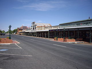
Coen is a rural town and coastal locality in the Shire of Cook, Queensland, Australia. The town of Coen is inland on the Peninsula Developmental Road, the main road on the Cape York Peninsula in far northern Queensland. In the 2021 census, the locality of Coen had a population of 320 people.

Croydon is a town and locality within the Shire of Croydon in Queensland, Australia. It is a terminus for the Normanton to Croydon railway line, which operates the Gulflander tourist train. At the 2016 census, Croydon had a population of 258 people.

Urana is a small town in the Riverina region of New South Wales, Australia. The town is in the Federation Council local government area.

Tingha is a small town on the Northern Tablelands, New South Wales, Australia in Inverell Shire. Formerly part of Armidale Region, on 1 July 2019, responsibility for Tingha was transferred from Armidale Regional Council to Inverell Shire Council. The town is 30 kilometres (19 mi) south of Inverell and 559 kilometres (347 mi) north-north-east of Sydney. Tingha is an Aboriginal word for "flat or level".

Yeronga is a southern riverside suburb in the City of Brisbane, Queensland, Australia. In the 2016 census, Yeronga had a population of 6,535 people.

The Rock is a town with a population of 1,236, in the Riverina region of southern New South Wales, Australia, in Lockhart Shire. It is 32 kilometres (20 mi) south-west of Wagga Wagga on the Olympic Highway.

Culcairn is a town in the south-east Riverina region of New South Wales, Australia. Culcairn is located in the Greater Hume Shire local government area on the Olympic Highway between Albury and Wagga Wagga. The town is 514 kilometres (319 mi) south-west of the state capital, Sydney and at the 2016 census had a population of 1,473.

Lockhart River is a town in the Aboriginal Shire of Lockhart River and a coastal locality split between the Aboriginal Shire of Lockhart River and the Shire of Cook, on the Cape York Peninsula in Queensland, Australia. In the 2016 census, Lockhart River had a population of 724 people.

Lockhart is a town in the Riverina Region of New South Wales, Australia. It is the location of the Lockhart Shire Council offices. At the 2016 census, Lockhart had a population of 818 people.

Lockhart Shire is a local government area in the Riverina region of New South Wales, Australia. The Shire was created in 1906 and is an agricultural and pastoral area.

Urana Shire was a local government area in the Riverina region of New South Wales, Australia. The Newell Highway crosses its north-west corner. The Shire included the town of Urana and the small towns of Boree Creek, Morundah, Oaklands and Rand.

The Shire of Cook is a local government area in Far North Queensland, Australia. The Shire covers most of the eastern and central parts of Cape York Peninsula, the most northerly section of the Australian mainland.

Milbrulong is a locality in the central east part of the Riverina region of New South Wales, Australia.
Osborne is a village community in the central east part of the Riverina. It is situated by road, about 15 kilometres south from Lockhart and 19 kilometres (12 mi) west from Woodend.
Yerong Creek is a closed railway station on the Main South railway line in New South Wales, Australia. The station opened in 1880 and consisted of a weatherboard station building and signal box. The platform buildings were demolished in the 1980s and only a low platform remains at the site.

Byfield is a rural locality in the Shire of Livingstone, Queensland, Australia. In the 2016 census, Byfield had a population of 301 people.

The Federation Council is a local government area located in the Riverina region of New South Wales, Australia. This area was formed in 2016 from the merger of the Corowa Shire with its neighbouring Urana Shire.

The Mangoplah Football Club is an Australian Rules Football club. It competes in and around the Wagga Wagga area in New South Wales, Australia. The Mangoplah Football Club was founded in 1913 by D J Lloyd, who became the club's first captain. In 1955 the club merged with Cookardinia United FC.
The Lockhart Football and Netball Club is situated in the Riverina, New South Wales area and currently plays in the Hume Football League and fields four football and five netball teams in this competition.
The Central Riverina Football League was a minor Australian rules football competition which ran from 1949 until 1981 in the Riverina region of New South Wales. The league contained a number of historic clubs, many of which no longer exist.


