Chiringa

Last updated

Chiringa
Malawi adm location map.svg
Red pog.svg
Chiringa
Map of Malawi showing the location of Chiringa.
Coordinates: 15°46′32″S35°46′02″E / 15.77556°S 35.76722°E / -15.77556; 35.76722 Coordinates: 15°46′32″S35°46′02″E / 15.77556°S 35.76722°E / -15.77556; 35.76722
Country Malawi
Region Southern Region
District Phalombe District
Elevation
1,700 m (5,600 ft)
Time zone UTC+2 (CAT)

Chiringa is a town in Malawi. [1]

Location

Chiringa is located approximately 20 kilometres (12 mi), by road, east of Phalombe, where the district headquarters are located. [2] This is approximately 104 kilometres (65 mi), by road, east of Blantyre, the financial capital of Malawi and the largest city in Malawi's Southern Region. [3] The geographical coordinates of Chiringa, Malawi are 15°46'32.0"S, 35°46'02.0"E (Latitude:-15.775556; Longitude:35.767222). [1]

Phalombe Malawian town

Phalombe is a town in Malawi. It is the district capital of Phalombe District.

Blantyre Place in Southern Region, Malawi

Blantyre is Malawi's centre of finance and commerce, and its second largest city, with an enumerated 800,264 inhabitants as of 2018. It is sometimes referred to as the commercial and industrial capital of Malawi as opposed to the political capital, Lilongwe. It is the capital of the country's Southern Region as well as the Blantyre District.

Contents

Overview

Chiringa lies along the Muloza–Chiringa Road (T415 Road), [4] which continues north-westwards to Migowi, about 13 kilometres (8 mi) from Chiringa. [5] The Migowi–Chiringa Road is already tarmacked, as of May 2019. [6]

The Muloza–Chiringa Road is a road in the Southern Region of Malawi, connecting the towns of Muloza in Mulanje District, and Chiringa, in Phalombe District.

There is a Post Office and a branch of First Discount House Bank in Chiringa. [1] Chiringa, like many localities in the country, is water stressed. This photograph shows a power truck drilling a borehole in Chiringa, Malawi. [7]

FDH Bank, also FDH Bank Limited, is a commercial bank in Malawi. It is one of the commercial banks licensed by the Reserve Bank of Malawi, the central bank and national banking regulator.

Notable people

Dr. Ken Lipenga was born on February 14, 1952 at Chiringa, Phalombe District. He is a Malawian politician, journalist, and writer. He is the current Member of Parliament for Phalombe East. He was the Minister of Finance under the presidency of Joyce Banda, until 10 October 2013, when he was dropped in a cabinet reshuffle and replaced with Maxwell Mkwezalamba following the Capital Hill Cashgate Scandal.

See also

Related Research Articles

Zomba, Malawi Place in Southern Region, Malawi

Zomba is a city in southern Malawi, in the Shire Highlands. It is the administrative capital of Zomba District.

Mulanje Place in Southern Region, Malawi

Mulanje is a town in the Southern Region, Malawi close to the border with Mozambique, to the east. It is near the Mulanje Massif.

Southern Region, Malawi Region in Malawi

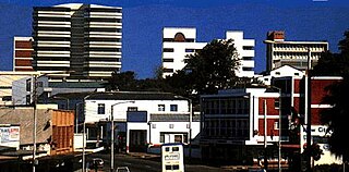
The Southern Region of Malawi is an area of Malawi. It covers an area of 31,753 km². Its capital city is Blantyre. In 2008, its population was 5,876,784.

Ntungamo Place in Uganda

Ntungamo is a town in the Western Region of Uganda. It is the largest town in Ntungamo District and the site of the district headquarters. It is the hometown of longtime President Yoweri Museveni.

Kapichira Hydroelectric Power Station building in Malawi

The Kapichira Power Station is a hydroelectric power plant on the Shire River in Malawi. It has an installed capacity of 128 megawatts (172,000 hp), enough to power over 86,000 homes, with four 32 megawatts (43,000 hp) generating sets. The power was developed in stages, with the first phase involving the installation of the first two 32 megawatts-generating turbines. Phase I of the power station was officially opened in September 2000.

The Nkhula B Hydroelectric Power Station, also Nkula B Hydroelectric Power Station is a hydroelectric power plant on the Shire River in Malawi. It has a power generating capacity of 100 megawatts (130,000 hp).

Namutumba, Uganda Place in Eastern Region of Uganda, Uganda

Namutumba is a town in the Namutumba District of the Eastern Region of Uganda. It is the main municipal, administrative, and commercial centre of the district.

Kanoni Place in Central Region of Uganda, Uganda

Kanoni, also Kanoni, Gomba or Kanoni–Gomba, is a town in the Central Region of Uganda. It is the commercial, administrative, and political headquarters of Gomba District.

Muyembe Place in Eastern Uganda, Uganda

Muyembe is a town in the Eastern Region of Uganda.

The Nkhula A Hydroelectric Power Station, also Nhula A Hydroelectric Power Station, is a hydroelectric power plant on the Shire River in Malawi. It has an installed capacity of 36 megawatts (48,000 hp), with three 12 megawatts (16,000 hp) generating sets. The power was developed in stages, with the first phase involving the installation of three 8 megawatts-generating turbines. Phase I of the power station was officially opened in 1966.

The Tedzani Hydroelectric Power Station, also Tedzani Hydroelectric Power Complex, is a complex of integrated hydroelectric power plants on the Shire River in Malawi. It has a planned installed capacity of 110.7 megawatts (148,500 hp), with four power stations adjacent to each other, sharing some of the physical infrastructure and electro-mechanical connections.

The Wovwe Hydroelectric Power Station, also Wovwe Power Station, is a hydroelectric power plant on the Wovwe River in Malawi. It has installed capacity of 4.35 megawatts (5,830 hp), with three generation units of 1.45 megawatts each.

Mpatamanga Hydroelectric Power Station

Mpatamanga Hydroelectric Power Station, also Mpatamanga Power Station, is a planned 350 megawatts (470,000 hp) hydroelectric power project to be constructed in Malawi.

University of Malawi College of Medicine

The University of Malawi College of Medicine (UMCM), also Malawi College of Medicine, is a constituent college of the University of Malawi, the oldest and largest public university in the country. The college houses the Faculty of Medicine of the University, and is the only medical school in Malawi.

Malindi, Malawi Place in Southern Region, Malawi

Malindi is a town in the Mangochi District, in the Southern Region of Malawi.

St Martins' Hospital, Malindi, is a 100-bed missionary community hospital in the town of Malindi, Malawi.

References

  1. 1 2 3 Google (10 May 2019). "Location of Chiringa, Phalombe District, Southern Region, Malawi" (Map). Google Maps . Google. Retrieved 10 May 2019.
  2. Globefeed.com (10 May 2019). "Distance between Phalombe, Southern Region, Malawi and Chiringa Trading Centre, PhalombeDistrict, Southern Region, Malawi". Globefeed.com. Retrieved 10 May 2019.
  3. Globefeed.com (10 May 2019). "Distance between Blantyre, Southern Region, Malawi and Chiringa Trading Centre, Phalombe District, Southern Region, Malawi". Globefeed.com. Retrieved 10 May 2019.
  4. Ronnex Chiwanda (25 February 2019). "Chief Bemoans Road Project Delay in PE". Lilongwe: ZodiakMalawi.com. Retrieved 10 May 2019.
  5. Globefeed.com (10 May 2019). "Distance between Chiringa Trading Centre, Phalombe District, Southern Region, Malawi and Migowi, Phalombe District, Southern Region, Malawi". Globefeed.com. Retrieved 10 May 2019.
  6. Google (10 May 2019). "Satellite Map Showing Tarmacked Migowi–Chiringa Road" (Map). Google Maps . Google. Retrieved 10 May 2019.
  7. University of Strathclyde (18 December 2018). "Clean Water for All in Malawi". Glasgow, Scotland, United Kingdom: University of Strathclyde . Retrieved 10 May 2019.
  8. Our World Leaders (2011). "Ken Lipenga: Minister of Economic Planning and Development of Malawi From 2008 Until 2010". OurWorldLeaders.com. Retrieved 10 May 2019.