Ramsgate railway station serves the town of Ramsgate in Thanet in Kent, England, and is at least 10 minutes' walk from the town centre. The station lies on the Chatham Main Line, 79 miles 21 chains (127.6 km) down the line from London Victoria, the Kent Coast Line, and the Ashford to Ramsgate line. The station is managed by Southeastern, which operates all trains serving it.
Transylvania Beach is a neighborhood of Louisville, Kentucky located on the Ohio River and centered along Transylvania Beach Road.

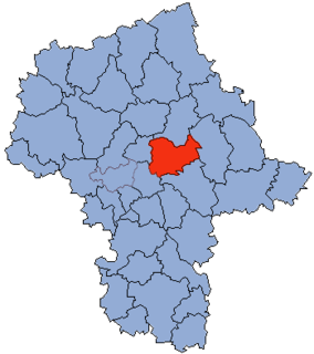
Brezovica is a village and municipality in Tvrdošín District in the Žilina Region of northern Slovakia.
Jigozen is a Hiroden station on Hiroden Miyajima Line, located in Jigozen, Hatsukaichi, Hiroshima.

Zieleniewo is a village in the administrative district of Gmina Chodecz, within Włocławek County, Kuyavian-Pomeranian Voivodeship, in north-central Poland.

Popeswood is a village in Berkshire, England, near Bracknell. The village is within the civil parish of Binfield approximately 1.5 miles (2.4 km) west of Bracknell. The main part of Popeswood lies north of the B3408 west of Temple Park and south of Binfield village, with a smaller section south of the B3408 between Amen Corner and Farley Wood.
Wiązówka is a village in the administrative district of Gmina Wyszogród, within Płock County, Masovian Voivodeship, in east-central Poland.
Strzyżewo is a village in the administrative district of Gmina Września, within Września County, Greater Poland Voivodeship, in west-central Poland.

St. George's College (S.G.C.) in Cairo, Egypt, is a boys' school that offers the basic three stages of the pre-university education system in Egypt. The primary language of instruction is English; nevertheless, social sciences are taught in Arabic. In addition, French is also taught as a second foreign language.

Milton Halt railway station is a former railway station that served the village of Milton in northern Oxfordshire, England.

Wang Tau Hom Estate is a public housing estate in Wang Tau Hom, Wong Tai Sin, Kowloon, Hong Kong, along Lung Cheung Road and next to Lok Fu. The estate was originally built in 1962 with a total of 25 blocks, but it was redeveloped between 1982 and 1983. It now consists of 18 blocks of three types, namely, Double H, Harmony 3 and Linear L with Linear 1 and Linear 3, providing a total of 5,900 domestic flats. There were originally had six more blocks, but these were allocated to Lok Fu Estate because they were near MTR Lok Fu Station after its 1991 construction.
Cangnan railway station is a railway station located in Zhejiang Province, People's Republic of China, on the Wenfu Railway which operated by Shanghai Railway Bureau, China Railway Corporation.
Jinxian South railway station is a railway station of Hangchangkun Passenger Railway located in Jiangxi, People's Republic of China.
Uluköy is a village in the District of Ulus, Bartın Province, Turkey. As of 2010 it had a population of 425 people.

The Oratory of the Madonna of San Colombano, also called the Chiese di San Colombano e Santa Maria dell'Orazione is a religious site in central Bologna, found on Via Parigi #5, near the Bologna Cathedral.

Katahri is a village in West Champaran district in the Indian state of Bihar.

Since the foreign intervention in Mali, Kidal was retaken by French, Malian, and Chadian troops. On 17 May 2014, Moussa Mara, the Malian prime minister came to visit Kidal.

On 31 January 2016, two suicide bombs and a car bomb exploded in the mainly Shi'ite town of Sayyidah Zaynab near Syria's holiest Shi'ite shrine, the Sayyidah Zaynab Mosque. At least 60 people were killed including 25 Shi'ite fighters and another 110 people were wounded in the explosions. The Islamic State of Iraq and the Levant claimed responsibility for the attack. This is second time the Sayyidah Zaynab Mosque shrine has been targeted; in February 2015 two suicide attacks killed four people and wounded thirteen.
The February 2016 Sayyidah Zaynab bombings occurred on 21 February 2016 after Islamic State of Iraq and the Levant militants detonated a car bomb and later launched two suicide bombings, about 400 meters from Sayyidah Zaynab Mosque, a Shia shrine, believed to contain the grave of Prophet Muhammad's granddaughter.
Singhrawan is a small town between Barhi and Chauparan in the Hazaribagh district of Jharkhand state in India. Its PIN code is 825406. This village is popularly known for its development.