In underwater diving activities such as saturation diving, technical diving and nitrox diving, the maximum operating depth (MOD) of a breathing gas is the depth below which the partial pressure of oxygen (pO2) of the gas mix exceeds an acceptable limit. This limit is based on risk of central nervous system oxygen toxicity, and is somewhat arbitrary, and varies depending on the diver training agency or Code of Practice, the level of underwater exertion planned and the planned duration of the dive, but is normally in the range of 1.2 to 1.6 bar.

Pin Oak is an unincorporated community in Hampshire County in the U.S. state of West Virginia. Pin Oak is located along West Virginia Route 29 between Paw Paw and Forks of Cacapon. Pin Oak is roughly centered at the intersection of Pin Oak Road and Cabin Run Road with West Virginia Route 29. The old Pinoak School lies north of this intersection.
The arrondissement of Corte is an arrondissement of France in the Haute-Corse department in the territorial collectivity of Corsica. It was expanded in 2010 with the four cantons of Alto-di-Casaconi, Fiumalto-d'Ampugnani, Campoloro-di-Moriani and Vescovato from the arrondissement of Bastia. It has 158 communes.

Sceneway Plaza is a shopping centre in Lam Tin, Kowloon, Hong Kong. It is also home to the East Kowloon Office of the Immigration Department. Established in 1991, the shopping centre is located adjacent to Lam Tin Station of Hong Kong's Mass Transit Railway (MTR). The plaza, which used to be a Japanese department store called Yaohan, contains many small stores including fashion, stationery, and music shops.

Llansannor is a small hamlet in the Vale of Glamorgan, Wales, United Kingdom.
Al Mushrif is a central neighborhood in the city of Abu Dhabi zone one. Al-Mushrif is located in an area between Sheikh Rashid Bin Saeed Street "Airport Road" and Arabian gulf Street, which extends to Mussafah Bridge. It contains the Al Mushrif Palace and Al Mushrif Park. It also contains the Women's Handicrafts Centre, demonstrating practices such as saddu and talli (embroidering).

Kállósemjén is a village in Szabolcs-Szatmár-Bereg county, in the Northern Great Plain region of eastern Hungary.

The Roman Catholic Diocese of Choluteca is a suffragan of the Archdiocese of Tegucigalpa. It was elevated on 29 August 1979.
Wielowieś is a village in the administrative district of Gmina Syców, within Oleśnica County, Lower Silesian Voivodeship, in south-western Poland. Prior to 1945 it was in Germany.
Rimington railway station was a railway station that served the small village of Rimington in Lancashire. It was built by the Lancashire and Yorkshire Railway. It was closed in July 1958, some four years prior to the withdrawal of passenger trains over the route.
Rumisapa District is one of eleven districts of the province Lamas in Peru.
Janczewo is a village in the administrative district of Gmina Wizna, within Łomża County, Podlaskie Voivodeship, in north-eastern Poland.

The Roman Catholic Diocese of Legazpi is a diocese of the Latin Rite of the Roman Catholic Church. It constitutes the entire province of Albay in the Philippines.

The Den Dolder–Baarn railway is a railway line in the province of Utrecht, Netherlands running from Den Dolder to Baarn, passing through Soest. It is also called the Sticht Line. Openend in 1898 in order to link Baarn with the city of Utrecht, it is operated by Nederlandse Spoorwegen and belongs to ProRail.

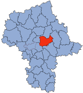
Ostrowik is a village in the administrative district of Gmina Poświętne, within Wołomin County, Masovian Voivodeship, in east-central Poland.
Ubowice is a village in the administrative district of Gmina Wielowieś, within Gliwice County, Silesian Voivodeship, in southern Poland.
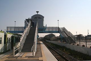
Urizura Station is a railway station on the Suigun Line in Naka, Ibaraki, Japan operated by East Japan Railway Company.

The Kanpur Memorial Church, originally called the All Souls' Cathedral is a church in Kanpur, India. It was built in 1875 in honour of the British who lost their lives during the Siege of Cawnpore in 1857.
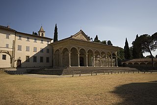
Santa Maria delle Grazie is a church in Arezzo, Tuscany, central Italy.

Homberg, Duisburg is a municipality and Stadtbezirk (district) within the city of Duisburg, Germany. The population is 39 725 and the district has an area of 37.1 km². It consists of the districts of Alt-Homberg, Hochheide, Baerl and Ruhrort.