Gmina Poświętne, Masovian Voivodeship

Last updated
Gmina Poświętne
Poświętne Commune
Gmina
POL gmina Poswietne (powiat wolominski) COA.jpg
Coat of arms
Poland adm location map.svg
Red pog.svg
Gmina Poświętne
Coordinates(Poświętne): 52°20′N21°26′E / 52.333°N 21.433°E / 52.333; 21.433
CountryFlag of Poland.svg  Poland
Voivodeship Masovian
County Wołomin
Seat Poświętne
Area
  Total 106.26 km2 (41.03 sq mi)
Population (2013 [1] )
  Total 6,081
  Density 57/km2 (150/sq mi)

Gmina Poświętne is a rural gmina (administrative district) in Wołomin County, Masovian Voivodeship, in east-central Poland. Its seat is the village of Poświętne, which lies approximately 12 kilometres (7 mi) east of Wołomin and 30 km (18 mi) north-east of Warsaw.

Gmina administrative division of Poland

The gmina is the principal unit of the administrative division of Poland, similar to a municipality. As of 2010 there were 2,478 gminy throughout the country. The word gmina derives from the German word Gemeinde, meaning "community".

Wołomin County County in Masovian, Poland

Wołomin County is a territorial and administrative division in Masovian Voivodeship, east-central Poland. It came into being on January 1, 1999, as a result of the Polish local government reforms passed in 1998. The administrative seat of the county and also its largest town is Wołomin, which lies 22 kilometres (14 mi) north-east of Warsaw. The county contains six other towns: Ząbki, 11 km (7 mi) south-west of Wołomin, Marki, 10 km (6 mi) west of Wołomin, Kobyłka, 3 km (2 mi) south-west of Wołomin, Zielonka, 8 km (5 mi) south-west of Wołomin, Radzymin, 9 km (6 mi) north-west of Wołomin, and Tłuszcz, 18 km (11 mi) north-east of Wołomin.

Masovian Voivodeship Voivodeship in Poland

Mazovian Voivodeship or Mazovia Province is the largest and most populous of the 16 Polish provinces, or voivodeships, created in 1999. It occupies 35,579 square kilometres (13,737 sq mi) of east-central Poland, and has 5,324,500 inhabitants. Its principal cities are Warsaw in the centre of the Warsaw metropolitan area, Radom (226,000) in the south, Płock (127,000) in the west, Siedlce (77,000) in the east, and Ostrołęka (55,000) in the north. The capital of the voivodeship is the national capital, Warsaw.

Contents

The gmina covers an area of 106.26 square kilometres (41.0 sq mi), and as of 2006 its total population is 5,849 (6,081 in 2013).

Villages

Gmina Poświętne contains the villages and settlements of Choiny, Cygów, Czubajowizna, Dąbrowica, Helenów, Jadwiniew, Józefin, Kielczykowizna, Kolno, Krubki-Górki, Laskowizna, Małków, Międzyleś, Międzypole, Nadbiel, Nowe Ręczaje, Nowy Cygów, Ostrowik, Poświętne, Ręczaje Polskie, Rojków, Trzcinka, Turze, Wola Cygowska, Wola Ręczajska, Wólka Dąbrowicka and Zabraniec.

Choiny, Wołomin County Village in Masovian, Poland

Choiny is a village in the administrative district of Gmina Poświętne, within Wołomin County, Masovian Voivodeship, in east-central Poland.

Cygów Village in Masovian, Poland

Cygów is a village in the administrative district of Gmina Poświętne, within Wołomin County, Masovian Voivodeship, in east-central Poland. It lies approximately 13 kilometres (8 mi) east of Wołomin and 32 km (20 mi) north-east of Warsaw.

Czubajowizna Village in Masovian, Poland

Czubajowizna is a village in the administrative district of Gmina Poświętne, within Wołomin County, Masovian Voivodeship, in east-central Poland. It lies approximately 11 kilometres (7 mi) east of Wołomin and 31 km (19 mi) north-east of Warsaw.

Neighbouring gminas

Gmina Poświętne is bordered by the town of Zielonka and by the gminas of Klembów, Stanisławów, Strachówka, Tłuszcz and Wołomin.

Zielonka Place in Masovian, Poland

Zielonka is a town in Wołomin County, Masovian Voivodeship, Poland, with 17,398 inhabitants (2013). It is located about 13 km to the north-east of the centre of Warsaw. City rights since 1960.

Gmina Klembów Gmina in Masovian, Poland

Gmina Klembów is a rural gmina in Wołomin County, Masovian Voivodeship, in east-central Poland. Its seat is the village of Klembów, which lies approximately 10 kilometres (6 mi) north-east of Wołomin and 31 km (19 mi) north-east of Warsaw.

Gmina Stanisławów is a rural gmina in Mińsk County, Masovian Voivodeship, in east-central Poland. Its seat is the village of Stanisławów, which lies approximately 12 kilometres (7 mi) north of Mińsk Mazowiecki and 39 km (24 mi) east of Warsaw.

Related Research Articles

Gmina Naruszewo is a rural gmina in Płońsk County, Masovian Voivodeship, in east-central Poland. Its seat is the village of Naruszewo, which lies approximately 11 kilometres south of Płońsk and 55 km north-west of Warsaw.

Gmina Wołomin Gmina in Masovian, Poland

Gmina Wołomin is an urban-rural gmina in Wołomin County, Masovian Voivodeship, in east-central Poland. Its seat is the town of Wołomin, which lies approximately 22 kilometres (14 mi) north-east of Warsaw.

Gmina Strachówka Gmina in Masovian, Poland

Gmina Strachówka is a rural gmina in Wołomin County, Masovian Voivodeship, in east-central Poland. Its seat is the village of Strachówka, which lies approximately 30 kilometres (19 mi) east of Wołomin and 51 km (32 mi) north-east of Warsaw.

Dąbrowica, Masovian Voivodeship Village in Masovian, Poland

Dąbrowica is a village in the administrative district of Gmina Poświętne, within Wołomin County, Masovian Voivodeship, in east-central Poland. It lies approximately 4 kilometres (2 mi) north of Poświętne, 14 km (9 mi) east of Wołomin, and 34 km (21 mi) north-east of Warsaw.

Jadwiniew Village in Masovian, Poland

Jadwiniew is a village in the administrative district of Gmina Poświętne, within Wołomin County, Masovian Voivodeship, in east-central Poland. It lies approximately 15 kilometres (9 mi) east of Wołomin and 33 km (21 mi) east of Warsaw.

Kolno, Masovian Voivodeship Village in Masovian, Poland

Kolno is a village in the administrative district of Gmina Poświętne, within Wołomin County, Masovian Voivodeship, in east-central Poland. It lies approximately 5 kilometres (3 mi) west of Poświętne, 10 km (6 mi) east of Wołomin, and 28 km (17 mi) north-east of Warsaw.

Międzyleś, Wołomin County Village in Masovian, Poland

Międzyleś is a village in the administrative district of Gmina Poświętne, within Wołomin County, Masovian Voivodeship, in east-central Poland. It lies approximately 17 kilometres (11 mi) east of Wołomin and 37 km (23 mi) north-east of Warsaw.

Nadbiel Village in Masovian, Poland

Nadbiel is a village in the administrative district of Gmina Poświętne, within Wołomin County, Masovian Voivodeship, in east-central Poland. It lies approximately 7 kilometres (4 mi) north-west of Poświętne, 9 km (6 mi) east of Wołomin, and 30 km (19 mi) north-east of Warsaw.

Nowy Cygów Village in Masovian, Poland

Nowy Cygów is a village in the administrative district of Gmina Poświętne, within Wołomin County, Masovian Voivodeship, in east-central Poland. It lies approximately 13 kilometres (8 mi) east of Wołomin and 32 km (20 mi) north-east of Warsaw.

Poświętne, Wołomin County Village in Masovian, Poland

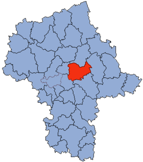
Poświętne is a village in Wołomin County, Masovian Voivodeship, in east-central Poland. It is the seat of the gmina called Gmina Poświętne. It lies approximately 14 kilometres (9 mi) east of Wołomin and 33 km (21 mi) north-east of Warsaw. It became a gmina in place of Cygów gmina and parish with its council, at the very end of the XIXth c., after the manor of Cygów was demolished and the estate auctioned off during Russian rule.

Ręczaje Polskie Village in Masovian, Poland

Ręczaje Polskie is a village in the administrative district of Gmina Poświętne, within Wołomin County, Masovian Voivodeship, in east-central Poland. It lies approximately 9 kilometres (6 mi) east of Wołomin and 28 km (17 mi) north-east of Warsaw.

Trzcinka, Masovian Voivodeship Village in Masovian, Poland

Trzcinka is a village in the administrative district of Gmina Poświętne, within Wołomin County, Masovian Voivodeship, in east-central Poland. It lies approximately 10 kilometres (6 mi) south-east of Wołomin and 26 km (16 mi) east of Warsaw.

Turze, Masovian Voivodeship Village in Masovian, Poland

Turze is a village in the administrative district of Gmina Poświętne, within Wołomin County, Masovian Voivodeship, in east-central Poland. It lies approximately 3 kilometres (2 mi) east of Poświętne, 16 km (10 mi) east of Wołomin, and 35 km (22 mi) east of Warsaw.

Wola Cygowska Village in Masovian, Poland

Wola Cygowska is a village in the administrative district of Gmina Poświętne, within Wołomin County, Masovian Voivodeship, in east-central Poland. It lies approximately 15 kilometres (9 mi) east of Wołomin and 32 km (20 mi) east of Warsaw.

Wola Ręczajska Village in Masovian, Poland

Wola Ręczajska is a village in the administrative district of Gmina Poświętne, within Wołomin County, Masovian Voivodeship, in east-central Poland. It lies approximately 12 kilometres (7 mi) east of Wołomin and 30 km (19 mi) east of Warsaw.

Wólka Dąbrowicka Village in Masovian, Poland

Wólka Dąbrowicka is a village in the administrative district of Gmina Poświętne, within Wołomin County, Masovian Voivodeship, in east-central Poland. It lies approximately 15 kilometres (9 mi) east of Wołomin and 35 km (22 mi) north-east of Warsaw.

Zabraniec Village in Masovian, Poland

Zabraniec is a village in the administrative district of Gmina Poświętne, within Wołomin County, Masovian Voivodeship, in east-central Poland. It lies approximately 9 kilometres (6 mi) south-east of Wołomin and 25 km (16 mi) east of Warsaw.

References


Coordinates: 52°19′47″N21°25′17″E / 52.32972°N 21.42139°E / 52.32972; 21.42139

Geographic coordinate system Coordinate system

A geographic coordinate system is a coordinate system that enables every location on Earth to be specified by a set of numbers, letters or symbols. The coordinates are often chosen such that one of the numbers represents a vertical position and two or three of the numbers represent a horizontal position; alternatively, a geographic position may be expressed in a combined three-dimensional Cartesian vector. A common choice of coordinates is latitude, longitude and elevation. To specify a location on a plane requires a map projection.