Gmina Klembów Klembów Commune | ||
---|---|---|
Gmina | ||
| ||
Coordinates(Klembów): 52°24′22″N21°19′52″E / 52.40611°N 21.33111°E Coordinates: 52°24′22″N21°19′52″E / 52.40611°N 21.33111°E | ||
Country | ||
Voivodeship | Masovian | |
County | Wołomin | |
Seat | Klembów | |
Area | ||
• Total | 85.79 km2 (33.12 sq mi) | |
Population (2013 [1] ) | ||
• Total | 9,493 | |
• Density | 110/km2 (290/sq mi) | |
Website | http://www.klembow.pl |
Gmina Klembów is a rural gmina (administrative district) in Wołomin County, Masovian Voivodeship, in east-central Poland. Its seat is the village of Klembów, which lies approximately 10 kilometres (6 mi) north-east of Wołomin and 31 km (19 mi) north-east of Warsaw.
The gmina is the principal unit of the administrative division of Poland, similar to a municipality. As of 2010 there were 2,478 gminy throughout the country. The word gmina derives from the German word Gemeinde, meaning "community".
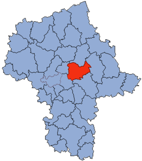
Wołomin County is a territorial and administrative division in Masovian Voivodeship, east-central Poland. It came into being on January 1, 1999, as a result of the Polish local government reforms passed in 1998. The administrative seat of the county and also its largest town is Wołomin, which lies 22 kilometres (14 mi) north-east of Warsaw. The county contains six other towns: Ząbki, 11 km (7 mi) south-west of Wołomin, Marki, 10 km (6 mi) west of Wołomin, Kobyłka, 3 km (2 mi) south-west of Wołomin, Zielonka, 8 km (5 mi) south-west of Wołomin, Radzymin, 9 km (6 mi) north-west of Wołomin, and Tłuszcz, 18 km (11 mi) north-east of Wołomin.
Mazovian Voivodeship or Mazovia Province is the largest and most populous of the 16 Polish provinces, or voivodeships, created in 1999. It occupies 35,579 square kilometres (13,737 sq mi) of east-central Poland, and has 5,324,500 inhabitants. Its principal cities are Warsaw in the centre of the Warsaw metropolitan area, Radom (226,000) in the south, Płock (127,000) in the west, Siedlce (77,000) in the east, and Ostrołęka (55,000) in the north. The capital of the voivodeship is the national capital, Warsaw.
The gmina covers an area of 85.79 square kilometres (33.1 sq mi), and as of 2006 its total population is 8,907 (9,493 in 2013).
Gmina Klembów contains the villages and settlements of Dobczyn, Karolew, Klembów, Krusze, Krzywica, Lipka, Michałów, Nowy Kraszew, Ostrówek, Pasek, Pieńki, Rasztów, Roszczep, Sitki, Stary Kraszew, Tuł and Wola Rasztowska.
Dobczyn is a village in the administrative district of Gmina Klembów, within Wołomin County, Masovian Voivodeship, in east-central Poland. It lies approximately 3 kilometres (2 mi) south-west of Klembów, 6 km (4 mi) north-east of Wołomin, and 28 km (17 mi) north-east of Warsaw.
Karolew is a village in the administrative district of Gmina Klembów, within Wołomin County, Masovian Voivodeship, in east-central Poland. It lies approximately 7 kilometres (4 mi) south-east of Klembów, 13 km (8 mi) east of Wołomin, and 33 km (21 mi) north-east of Warsaw.
Klembów is a village in Wołomin County, Masovian Voivodeship, in east-central Poland. It is the seat of the gmina called Gmina Klembów. It lies approximately 8 kilometres (5 mi) north-east of Wołomin and 30 km (19 mi) north-east of Warsaw.
Gmina Klembów is bordered by the gminas of Dąbrówka, Poświętne, Radzymin, Tłuszcz and Wołomin.
Gmina Dąbrówka is a rural gmina in Wołomin County, Masovian Voivodeship, in east-central Poland. Its seat is the village of Dąbrówka.
Gmina Poświętne is a rural gmina in Wołomin County, Masovian Voivodeship, in east-central Poland. Its seat is the village of Poświętne, which lies approximately 12 kilometres (7 mi) east of Wołomin and 30 km (18 mi) north-east of Warsaw.
Gmina Radzymin is an urban-rural gmina in Wołomin County, Masovian Voivodeship, in east-central Poland. Its seat is the town of Radzymin, which lies approximately 9 kilometres (6 mi) north-west of Wołomin and 26 km (16 mi) north-east of Warsaw.
Gmina Wołomin is an urban-rural gmina in Wołomin County, Masovian Voivodeship, in east-central Poland. Its seat is the town of Wołomin, which lies approximately 22 kilometres (14 mi) north-east of Warsaw.
Gmina Jadów is a rural gmina in Wołomin County, Masovian Voivodeship, in east-central Poland. Its seat is the village of Jadów, which lies approximately 30 kilometres (19 mi) north-east of Wołomin and 50 km (31 mi) north-east of Warsaw.
Gmina Strachówka is a rural gmina in Wołomin County, Masovian Voivodeship, in east-central Poland. Its seat is the village of Strachówka, which lies approximately 30 kilometres (19 mi) east of Wołomin and 51 km (32 mi) north-east of Warsaw.
Gmina Tłuszcz is an urban-rural gmina in Wołomin County, Masovian Voivodeship, in east-central Poland. Its seat is the town of Tłuszcz, which lies approximately 18 kilometres (11 mi) north-east of Wołomin and 39 km (24 mi) north-east of Warsaw.
Krusze is a village in the administrative district of Gmina Klembów, within Wołomin County, Masovian Voivodeship, in east-central Poland. It lies approximately 6 kilometres (4 mi) north-east of Klembów, 13 km (8 mi) north-east of Wołomin, and 35 km (22 mi) north-east of Warsaw.
Krzywica is a village in the administrative district of Gmina Klembów, within Wołomin County, Masovian Voivodeship, in east-central Poland. It lies approximately 3 kilometres (2 mi) south-east of Klembów, 9 km (6 mi) north-east of Wołomin, and 31 km (19 mi) north-east of Warsaw.
Lipka is a village in the administrative district of Gmina Klembów, within Wołomin County, Masovian Voivodeship, in east-central Poland. It lies approximately 3 kilometres (2 mi) south-east of Klembów, 9 km (6 mi) north-east of Wołomin, and 31 km (19 mi) north-east of Warsaw.
Michałów is a village in the administrative district of Gmina Klembów, within Wołomin County, Masovian Voivodeship, in east-central Poland. It lies approximately 2 kilometres (1 mi) north of Klembów, 10 km (6 mi) north-east of Wołomin, and 31 km (19 mi) north-east of Warsaw.
Nowy Kraszew is a village in the administrative district of Gmina Klembów, within Wołomin County, Masovian Voivodeship, in east-central Poland.
Ostrówek is a village in the administrative district of Gmina Klembów, within Wołomin County, Masovian Voivodeship, in east-central Poland. It lies approximately 4 kilometres (2 mi) south-east of Klembów, 10 km (6 mi) east of Wołomin, and 32 km (20 mi) north-east of Warsaw.
Rasztów is a village in the administrative district of Gmina Klembów, within Wołomin County, Masovian Voivodeship, in east-central Poland. It lies approximately 5 kilometres (3 mi) west of Klembów, 8 km (5 mi) north of Wołomin, and 29 km (18 mi) north-east of Warsaw.
Roszczep is a village in the administrative district of Gmina Klembów, within Wołomin County, Masovian Voivodeship, in east-central Poland. It lies approximately 5 kilometres (3 mi) north of Klembów, 13 km (8 mi) north-east of Wołomin, and 34 km (21 mi) north-east of Warsaw.
Tuł is a village in the administrative district of Gmina Klembów, within Wołomin County, Masovian Voivodeship, in east-central Poland. It lies approximately 6 kilometres (4 mi) south-east of Klembów, 12 km (7 mi) east of Wołomin, and 33 km (21 mi) north-east of Warsaw.
Wola Rasztowska is a village in the administrative district of Gmina Klembów, within Wołomin County, Masovian Voivodeship, in east-central Poland. It lies approximately 6 kilometres (4 mi) north-west of Klembów, 12 km (7 mi) north of Wołomin, and 33 km (21 mi) north-east of Warsaw.