Chondria tumulosa

Last updated

Chondria tumulosa
Scientific classification Red Pencil Icon.png
(unranked): Archaeplastida
Division: Rhodophyta
Class: Florideophyceae
Order: Ceramiales
Family: Rhodomelaceae
Genus: Chondria
Species:
C. tumulosa
Binomial name
Chondria tumulosa
A.R.Sherwood et J.M.Huisman

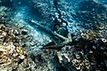
Chondria tumulosa is a species of red algae in the family Rhodomelacae. It was first discovered in 2016, growing in small patches in the Pearl and Hermes Atoll in the Northwestern Hawaiian Islands. By 2019, the species had spread to cover several thousand square meters, smothering and killing vast swathes of the atoll's coral reefs. C. tumulosa is unlike any other species in its genus, having a tumbleweed-like growth form that allows fragments to break off and spread, allowing it to colonize new areas. The true origin of C. tumulosa in the region remains unknown; it displays many characteristics of an invasive species and is not closely related to any other Hawaiian Chondria , but it would have been relatively difficult to colonize such a remote area. It has also been suggested that it is a native species that suddenly spread due to changes in the ecosystem. Control and mitigation strategies will have to be made to prevent the species' spread. [1] [2] [3]

Related Research Articles

Palmyra Atoll Uninhabited Pacific atoll and unorganized incorporated U.S. territory

Palmyra Atoll, also referred to as Palmyra Island, is one of the Northern Line Islands. It is located almost due south of the Hawaiian Islands, roughly one-third of the way between Hawaii and American Samoa. North America is almost 3,355 miles to the northeast. The atoll is 4.6 sq mi (12 km2), lying in the equatorial Northern Pacific Ocean. Its 9 miles (14 km) of coastline has one anchorage known as West Lagoon.

Coral reef Outcrop of rock in the sea formed by the growth and deposit of stony coral skeletons

A coral reef is an underwater ecosystem characterized by reef-building corals. Reefs are formed of colonies of coral polyps held together by calcium carbonate. Most coral reefs are built from stony corals, whose polyps cluster in groups.

Kure Atoll Atoll of the Hawaiian Islands

Kure Atoll or Ocean Island is an atoll in the Pacific Ocean 48 nautical miles west-northwest of Midway Atoll in the Northwestern Hawaiian Islands at 28°25′N178°20′W. A coral ring six miles across encloses a lagoon several meters deep. The only land of significant size is called Green Island and is a habitat for hundreds of thousands of seabirds. A short, unused and unmaintained runway and a portion of one building, both from a former United States Coast Guard LORAN station, are located on the island. Politically, it is part of Hawaii, although separated from the rest of the state by Midway, which is a separate unorganized territory. Green Island, in addition to being the nesting grounds for tens of thousands of seabirds, has recorded several vagrant terrestrial birds, including snow bunting, eyebrowed thrush, brambling, olive-backed pipit, black kite, Steller's sea eagle and Chinese sparrowhawk. It is currently managed as a Wildlife Bird Sanctuary by the State of Hawaii's Department of Land and Natural Resource—Division of Forestry and Wildlife as one of the co-trustees of Papahānaumokuākea Marine National Monument with support from the Kure Atoll Conservancy.

Grey reef shark Species of shark

The grey reef shark is a species of requiem shark, in the family Carcharhinidae. One of the most common reef sharks in the Indo-Pacific, it is found as far east as Easter Island and as far west as South Africa. This species is most often seen in shallow water near the drop-offs of coral reefs. It has the typical "reef shark" shape, with a broad, round snout and large eyes. It can be distinguished from similar species by the plain or white-tipped first dorsal fin, the dark tips on the other fins, the broad, black rear margin on the tail fin, and the lack of a ridge between the dorsal fins. Most individuals are less than 1.88 m (6.2 ft) long.

French Frigate Shoals Atoll in Hawaii

The French Frigate Shoals is the largest atoll in the Northwestern Hawaiian Islands. Its name commemorates French explorer Jean-François de La Pérouse, who nearly lost two frigates when attempting to navigate the shoals. It consists of a 20-mile (32 km) long crescent-shaped reef, twelve sandbars, and the 120-foot (37 m) high La Perouse Pinnacle, the only remnant of its volcanic origins. The total land area of the islets is 61.508 acres (24.891 ha). Total coral reef area of the shoals is over 232,000 acres (94,000 ha). Tern Island, with an area of 26.014 acres (10.527 ha), has a landing strip and permanent habitations for a small number of people. It is maintained as a field station in the Hawaiian Islands National Wildlife Refuge by the United States Fish and Wildlife Service. The French Frigate Shoals are about 487 nautical miles northwest of Honolulu.

Northwestern Hawaiian Islands Small islands and atolls in Hawaii

The Northwestern Hawaiian Islands or Leeward Islands are the small islands and atolls in the Hawaiian island chain located northwest of the islands of Kauai and Niihau. Politically, they are all part of Honolulu County in the U.S. state of Hawaii, except Midway Atoll, which is a territory distinct from the State of Hawaii, and grouped as one of the United States Minor Outlying Islands. The United States Census Bureau defines this area, except Midway, as Census Tract 114.98 of Honolulu County. Its total land area is 3.1075 square miles (8.048 km2). All the islands except Nihoa are north of the Tropic of Cancer, making them the only islands in Hawaii that lie outside the tropics.

Pearl and Hermes Atoll Atoll of Hawaii

The Pearl and Hermes Atoll is part of the Northwestern Hawaiian Islands, a group of small islands and atolls that form the farthest northwest portion of the Hawaiian island chain. The atoll consists of a variable number of flat and sandy islets, typically between five and seven. More were noted in historical sources but have since been lost to erosion and rising sea levels.

Bokak Atoll Atoll in the Marshall Islands

Bokak Atoll or Taongi Atoll is an uninhabited coral atoll in the Ratak Chain of the Marshall Islands, in the North Pacific Ocean. Due to its relative isolation from the main islands in the group, Bokak's flora and fauna has been able to exist in a pristine condition.

Giant clam Species of bivalve

The giant clams are the members of the clam genus Tridacna that are the largest living bivalve mollusks. There are actually several species of "giant clams" in the genus Tridacna, which are often misidentified for Tridacna gigas, the most commonly intended species referred to as “the giant clam”.

Pacific Remote Islands Marine National Monument Group of unorganized United States Pacific Island territories

The Pacific Remote Islands Marine National Monument is a group of unorganized, mostly unincorporated United States Pacific Island territories managed by the United States Fish and Wildlife Service of the United States Department of the Interior and the National Oceanic and Atmospheric Administration (NOAA) of the United States Department of Commerce. These remote refuges are "the most widespread collection of marine- and terrestrial-life protected areas on the planet under a single country's jurisdiction". They protect many endemic species including corals, fish, shellfish, marine mammals, seabirds, water birds, land birds, insects, and vegetation not found elsewhere.

Rawaki Uninhabited atoll of central Kiribati

Rawaki is one of the Phoenix Islands in the Republic of Kiribati, also known by its previous name of Phoenix Island. It is a small, uninhabited atoll, approximately 1.2 by 0.8 kilometres in size and 65 hectares in area, with a shallow, brackish lagoon that is not connected to the open sea. It is located at 3.721°S 170.712°W.

<i>Montipora dilatata</i> Species of coral

Montipora dilatata, commonly known as the Hawaiian reef coral, is a species of coral in the family Acroporidae.

Coral reef fish Fish which live amongst or in close relation to coral reefs

Coral reef fish are fish which live amongst or in close relation to coral reefs. Coral reefs form complex ecosystems with tremendous biodiversity. Among the myriad inhabitants, the fish stand out as colourful and interesting to watch. Hundreds of species can exist in a small area of a healthy reef, many of them hidden or well camouflaged. Reef fish have developed many ingenious specialisations adapted to survival on the reefs.

<i>Tubastraea</i> Genus of corals

Tubastraea, also known as sun coral or sun polyps, is a genus of coral in the phylum Cnidaria. It is a cup coral in the family Dendrophylliidae.

Phoenix Islands Protected Area Marine protected area in central Kiribati

The Phoenix Islands Protected Area (PIPA) is located in the Republic of Kiribati, an ocean nation in the central Pacific approximately midway between Australia and Hawaii. PIPA constitutes 11.34% of Kiribati's exclusive economic zone (EEZ), and with a size of 408,250 km2 (157,630 sq mi), it is one of the largest marine protected areas (MPA) and one of the largest protected areas of any type on Earth. The PIPA was also designated as the world’s largest and deepest UNESCO World Heritage Site in 2010.

Mesophotic coral reef

A Mesophotic Coral Reefs or Mesophotic Coral Ecosystem (MCE), originally from the latin word meso meaning middle and photic meaning light, is characterised by the presence of both light dependent coral and algae, and organisms that can be found in water with low light penetration. Mesophotic Coral Ecosystem (MCEs) is a new widely adopted term use to refer mesophotic coral reefs that contrasting other similar terms like "deep coral reef" and "twilight zone", since those terms sometimes are confused due to a lot of intercept between them.

Carijoa riisei, the snowflake coral or branched pipe coral, is a species of soft coral in the family Clavulariidae. It was originally thought to have been native to the tropical western Atlantic Ocean and subsequently spread to other areas of the world such as Hawaii and the greater tropical Pacific, where it is regarded as an invasive species. The notion that it is native to the tropical western Atlantic was perpetuated from the fact that the type specimen, described by Duchassaing & Michelotti in 1860, was collected from the US Virgin Islands. It has subsequently been shown through molecular evidence that it is more likely that the species is in fact native to the Indo-Pacific and subsequently spread to the western tropical Atlantic most likely as a hull fouling species prior to its original description.

Coral reefs of Tuvalu List of coral reefs in Tuvalu

The coral reefs of Tuvalu consist of three reef islands and six atolls, containing approximately 710 km2 (270 sq mi) of reef platforms. The islands of the Tuvalu archipelago are spread out between the latitude of 5° to 10° south and longitude of 176° to 180°, west of the International Date Line. The islands of Tuvalu are volcanic in origin. On the atolls, an annular reef rim surrounds the lagoon, and may include natural reef channels. The reef islands have a different structure to the atolls, and are described as reef platforms as they are smaller tabular reef platforms that do not have a salt-water lagoon, although they may have a completely closed rim of dry land, with the remnants of a lagoon that has no direct connection to the open sea or that may be drying up.

Coral reefs of Kiribati Pacific Ocean Island chain

The Coral reefs of Kiribati consists of 32 atolls and one raised coral island, Banaba, which is an isolated island between Nauru and the Gilbert Islands. The islands of Kiribati are dispersed over 3.5 million km2 (1.4 million sq mi) of the Pacific Ocean and straddle the equator and the 180th meridian, extending into the eastern and western hemispheres, as well as the northern and southern hemispheres. 21 of the 33 islands are inhabited. The groups of islands of Kiribati are:

Coral reefs of the Solomon Islands

The Coral reefs of the Solomon Islands consists of six major islands and over 986 smaller islands, in Oceania, to the east of Papua New Guinea and northwest of Vanuatu. The Solomon Islands lie between latitudes 5° and 13°S, and longitudes 155° and 169°E. The distance between the westernmost and easternmost islands is about 1,500 km (930 mi). The Santa Cruz Islands are situated north of Vanuatu and are especially isolated at more than 200 km (120 mi) from the other islands. The Solomon Islands has the 22nd largest Exclusive Economic Zone of 1,589,477 km2 (613,701 sq mi) of the Pacific Ocean.

References

  1. Sherwood, Alison R.; Huisman, John M.; Paiano, Monica O.; Williams, Taylor M.; Kosaki, Randall K.; Smith, Celia M.; Giuseffi, Louise; Spalding, Heather L. (2020-07-07). "Taxonomic determination of the cryptogenic red alga, Chondria tumulosa sp. nov., (Rhodomelaceae, Rhodophyta) from Papahānaumokuākea Marine National Monument, Hawai'i, USA: A new species displaying invasive characteristics". PLOS ONE. 15 (7): e0234358. doi: 10.1371/journal.pone.0234358 . ISSN   1932-6203. PMC   7340295 . PMID   32634147.
  2. "Algae species discovered infesting NW Hawaiian waters has been identified". ScienceDaily. Retrieved 2020-07-09.
  3. Fazio, Marie (2020-07-08). "New Red Algae Are Threatening Hawaii's Coral Reefs, Scientists Say". The New York Times. ISSN   0362-4331 . Retrieved 2020-07-09.