
Christon Bank is a small village in Northumberland, England, 9 miles north of the town of Alnwick. Prior to 1847 it was a small farming hamlet, which was transformed by the building of the East Coast Main Line railway.
Christon Bank is a small village in Northumberland, England, 9 miles north of the town of Alnwick. Prior to 1847 it was a small farming hamlet, which was transformed by the building of the East Coast Main Line railway.
The village is named after the Christon (originally Cryston) family, who were local yeoman farmers and members of the Quaker movement. In 1598 Thomas Cryston was recorded as the freeholder who held a quarter of a freehold in a local farm. The family eventually purchased the land outright from Henry Darling before it was sold in 1759 to Henry Taylor of Rock, who extended the property to the west. The farm was further expanded in the 19th century as it embraced the onset of modern farming methods such as new fertilisers, drainage and machinery. [1] Today Christon Bank Farm is a Grade II listed building [2] and is still the predominant farm in the area.
The predominance of farming in the locality led to the setting up of commercial lime production in the area in the early part of the 19th century. The lime was produced as fertiliser for the local farms. A kiln was constructed in the early 1800s followed by a second one later in the century. The OS map of 1865 also shows a lime works on the site and a small quarry. The site of the lime kilns is 500 metres (1,600 ft) south-east of the village; both kilns are grade II listed buildings and received some renovation in 2005 with funding from DEFRA and co-operation from the local landowner. [3] [4] Other industry in the immediate area at that time included small-scale coal mining; the mine to the south of the village on the road to Rennington produced coal to burn at the lime kilns and for local use. [5]

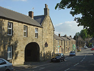
Prior to the opening of the railway in 1847, Christon Bank consisted of just fourteen dwellings including two public houses, the Blink Bonny and the Rising Sun. The arrival of the railway and the accompanying station transformed Christon Bank from a quiet farming hamlet to a busy village with the facilities of a main line station, which in 1885 dealt with over 10,000 passengers, over 6,000 livestock and 2,000 tons of raw materials. The raw materials included whinstone quarried at Embleton 1.6 kilometres (0.99 mi) to the east and brought by cart. A 2.4-kilometre (1.5 mi)-long tramway, known as Johnny’s Line, was built in 1895 to bring the stone directly from the quarry to the station. The tramway ran alongside the road from Embleton and had fallen out of use by the end of World War II. [6]
The expansion of the village continued with the construction of a Primitive Methodist chapel in 1891 on the initiative of the station master Theopilus Moor and James Young who approached the Liberal statesman Sir Edward Grey for a donation of land which was approved; the first stone was laid in a special ceremony on 3 August 1891. [7] Three more cottages were also built by the end of the century. In 1900 a laundry was set up by Lady Grey of nearby Fallodon to provide employment for local women; at that time the village had a population of 105. [8]
A major expansion of the village started in the late 1980s with the building of the Mount View residential estate on land to the west of the railway. Further housing was built on the site of the old railway sidings to the east of the line. The station itself closed in 1965 as part of the Beeching cuts, leaving the village with a feeling of a dormitory village, although the level crossing is in constant use with 100 trains a day passing through. [9] The old station buildings have been converted to residential use. The Rising Sun pub is now closed and is rented as a holiday cottage. The Blink Bonny remains as the only public house in the village; dating from the 1820s, it was named after the race horse Blink Bonny, the winner of The Derby in 1857: two of the horse‘s hooves are on display in a cabinet in the pub. [10] The village also has a convenience store, Post Office and art shop. There are two caravan sites, the large Christon Bank Caravan Park and the smaller Pippins Park. A further housing development of twelve detached houses known as Horsley Grange was completed just to the east of the village in 2013. [11]
In 2011 it was estimated that 220 people lived in Christon Bank. [5]

Embleton is a village and civil parish in the English county of Northumberland. Besides the village of Embleton itself, the civil parish includes the settlement of Christon Bank, situated about a mile to the west.
Crich is a village in the English county of Derbyshire. The population at the 2001 Census was 2,821, increasing to 2,898 at the 2011 Census. It has the National Tramway Museum inside the Crich Tramway Village and, at the summit of Crich Hill above, a memorial tower for those of the Sherwood Foresters regiment who died in battle, particularly in World War I.
Dove Holes is a village in the High Peak district of Derbyshire, England. It has a population of about 1,200 (2001), shown in the 2011 Census as being included in the population of Chapel-en-le-Frith. It straddles the A6 road approximately three miles north of Buxton and three miles south of Chapel-en-le-Frith. Trains run from Dove Holes railway station into Manchester.

Betchworth is a village and civil parish in the Mole Valley district of Surrey, England. The village centre is on the north bank of the River Mole and south of the A25 road, almost 3 miles (4.8 km) east of Dorking and 3 miles (4.8 km) west of Reigate. London is 19.5 miles (31.4 km) north of the village.

Blisworth is a village and civil parish in the West Northamptonshire, England. The West Coast Main Line, from London Euston to Manchester and Scotland, runs alongside the village partly hidden and partly on an embankment. The Grand Union Canal passes through the village and the north portal of the Blisworth tunnel is near Stoke Road.

Newbiggin is a small village in Cumbria, North West England. It is in the Dacre civil parish about 3 mi (4.8 km) west of Penrith. It lies at 750 ft (230 m) sheltered from the prevailing south-westerly wind by Flusco Pike, 150 ft (46 m) higher. It is described as a "non-nucleated village," lying for a mile along either side of the C3019 between the A66 and the B5288. There are at least six other villages in Cumbria with the same name, which is derived from the Old English ‘new biggin', or new house. Locally this village is referred to as the "Stainton Newbiggin," to distinguish it from the others.

Limehouse is a community in the Town of Halton Hills in southern Ontario, Canada. It has a population of about 800 people and its closest neighbours are Georgetown and Acton. Limehouse has many hills, trails and even a small school.

Consall is a small village situated in the Staffordshire Moorlands, Staffordshire, England. It is approximately 6 miles south of the market town of Leek and 8 miles east of Stoke-on-Trent. According to the last Census taken in 2001, Consall had a population of 118, increasing to 150 at the 2011 census.
The Hook Norton ironstone quarries (Brymbo) were ironstone quarries near Hook Norton in Oxfordshire, England. The quarries were in operation from 1899 to 1946 supplying ironstone to the Brymbo Steelworks in Wrexham and were served by the Brymbo Ironworks Railway, an extensive, 2 ft (610 mm) narrow gauge industrial railway.

Penwyllt is a hamlet located in the upper Swansea Valley in Powys, Wales, lying within the Brecon Beacons National Park.
Charlestown is a village in Fife, Scotland. It lies on the north shore of the Firth of Forth, around 1 mile (1.6 km) west of Limekilns and 3 miles (5 km) south-west of Dunfermline.

Annery kiln is a former limekiln of the estate of Annery, in the parish of Monkleigh, North Devon. It is situated on the left bank of the River Torridge near Half-Penny Bridge, built in 1835, which connects the parishes of Monkleigh and Weare Giffard. Running by it today is A386 road from Bideford to Great Torrington. Weare Giffard is the start of the tidal section of the River Torridge, and thus the kiln was sited here to import by river raw materials for the kiln, the product of which was lime fertiliser for use on inland agricultural fields. The old lime kiln is thus situated between the River Torridge and the now filled-in Rolle Canal built circa 1827 and railway that ran formerly from Bideford to Torrington, opened in 1872 and closed in 1966. The old trackbed now forms a stretch of the Tarka Trail.

Broadstone lies close to the small village of Gateside in North Ayrshire, Scotland about half a mile east of Beith in the old Barony of Giffen.

Blink Bonny (1854–1862) was a British Thoroughbred racehorse and broodmare. In a career that lasted from 1856 to 1858, she ran twenty times and won fourteen races. She was the leading British two-year-old of 1856, when she won eight races including the Gimcrack Stakes at York. In 1857 Blink Bonny won five of her seven races and became the second filly, after Eleanor, to defeat the colts in The Derby. In the same season, racing against her own sex, she won The Oaks, the Lancashire Oaks, and the Park Hill Stakes.

The Holy Island Waggonway was a network of waggonways across the island of Lindisfarne, Northumberland, England.

Cocking Lime Works and its associated chalk quarry are abandoned industrial sites in the South Downs of England. They are to the south of the village of Cocking, West Sussex, close to the South Downs Way. The works are on land owned by the Cowdray Estate and are not open to the public. Cocking was the source of lime used for the manufacture of Midhurst White bricks and for agricultural purposes.

Llanymynech Heritage Area is an historic former lime kiln, quarry and industrial site near the village of Llanymynech, Shropshire in the Welsh Marches. The site is adjacent to the A483 road and close to the Montgomery Canal. It is about 6 miles (10 km) south of Oswestry on the English side of the border, and about 9 miles (14 km) north of the Powys town of Welshpool.

Grove Lime Kiln is a disused 19th century lime kiln on the Isle of Portland, Dorset, England. It is located close to HM Prison Portland and The Grove village. Owned by the prison service, the lime kiln has been Grade II Listed since 2009.

The Ratgoed Tramway was a 2 ft 3 in gauge horse-worked tramway that connected the remote Ratgoed Quarry with the Corris Railway at Aberllefenni. It was 1.75 miles (2.82 km) long.

The Darnley Lime Works Tramway and Mineral Railway consisted of a narrow gauge field railway and probably a standard gauge works railway at today's Dams to Darnley Country Park in East Renfrewshire, 9.7 km southwest of Glasgow. They were successively operated at least from 1898 to 1959.