Church of the Ascension, Whixley

Last updated

Church of the Ascension, Whixley
Church of St James
Church of the Ascension, Whixley - geograph.org.uk - 2857237.jpg
Church of the Ascension, Whixley
North Yorkshire UK location map (2023).svg
Red pog.svg
Church of the Ascension, Whixley
Location within North Yorkshire
54°01′05″N1°19′37″W / 54.018°N 1.327°W / 54.018; -1.327
OS grid reference SE442583
Location Whixley, North Yorkshire,
CountryEngland
Denomination Anglican
Website www.achurchnearyou.com/church/3315/
History
Former namesChurch of St James
Church of St Mary
Status Parish church
Architecture
Functional statusActive
Style Decorated
Clergy
Vicar(s) Reverend Sarah Feaster
Listed Building – Grade II*
Designated15 March 1966
Reference no. 1189906

The Church of the Ascension is an Anglican church in the village of Whixley, North Yorkshire, England. Whilst the Domesday Book entry for Whixley mentions the presence of a church, the main fabric of the existing church dates to the 14th century. Up until it was renovated in the 19th century, it was dedicated to St James, but was rededicated as the Church of the Ascension, and it is now a grade II* listed building. Nikolaus Pevsner notes that it is unusual for a village church to be composed of mostly the same style of architecture (Decorated).

Contents

History

The stone fabric of the church dates back to the 12th and 14th centuries, whilst some believe that stone from the Roman town of Aldborough (Isurium) was used in building the church. [1] [2] The entry for Whixley in the Domesday Survey mentions a church, though this is not the current structure. [3] [note 1] The walls of the church were noted in the 19th century as being "marked with fire". It is thought this was the result of the church being burnt by Scottish raiders in 1319. [6]

The fabric of the church consists of ashlar walls, slate and lead roof, with a west tower that has "an embattled parapet with crocketed finials and a pyramidal roof". [7] The tower is in three stages, with a Perpendicular design. [8] The nave has been described as having very narrow aisles, [9] and it is separated from the other parts of the church by three arches on each side, supported by clustered pillars which display carved heads. [10] The pulpit is carved from Caen stone, having been installed during renovations. [11]

Up until the Reformation, the church belonged to the Priory of Knaresborough, who had the right of advowson. [12] [note 2] Christopher Tancred, who died in 1754, left specific instructions in his will that he was not to be buried underground. After being left in the family manor house in various places for 150 years, his sarcophagus was eventually moved into the church in 1905. [15]

The church was closed for 16 months between 1861 and July 1862 for renovations carried out by George Gilbert Scott which cost £2,949 (equivalent to £293,000in 2021). [12] [16] Upon re-opening, it was rededicated as the Church of the Ascension, previously having been the Church of St James, or St Mary's. [17] During the renovations, a brick wall that extended from the tower through the aisles and blocking up the west window was removed. [18]

Although the tower is part Perpendicular, the rest of the church is in the Decorated style, something which Pevsner notes as being unusual for a village church developed over some time. [19]

Parish and benefice

The parish of Whixley is within a shared benefice known as Great and Little Ouseburn, with Marton cum Grafton and Whixley with Green Hammerton. The parish of Whixley and Green Hammerton has a daughter church (chapel-of-ease) in Green Hammerton. [20] The church is part of the Deanery of Ripon, the Archdeaconry of Richmond and Craven, and the Diocese of Leeds. [21] Historically, the church was in the Deanery of Boroughbridge, which was part of the Diocese of Chester. [6]

Notes

  1. Whixley is listed as Cvcheslage or as Crucheslaga and different translations state either the one church or two churches. At that time, Whixley was in Borgescire, which later became the Wapentake of Lower Claro. [4] [5]
  2. The Priory of Knaresborough was an order of Trinitarians founded by Robert of Knaresborough. The church at Whixley was appropriated to "St Roberts Juxta Knaresborough" in 1375. Besides Whixley, the order also had churches in Pannal and Hampsthwaite. [13] [14]

Related Research Articles

<span class="mw-page-title-main">Howdenshire</span> Former administrative division of Yorkshire, England

Howdenshire was a wapentake and a liberty of England, lying around the town of Howden in the East Riding of Yorkshire.

<span class="mw-page-title-main">Aldbrough, East Riding of Yorkshire</span> Village and civil parish in the East Riding of Yorkshire, England

Aldbrough is a village and civil parish in the East Riding of Yorkshire, England, about 12 miles (19 km) north-east of Hull at the junction of the B1242 and B1238 roads. It lies near to the North Sea coast within the area of Holderness.

<span class="mw-page-title-main">Asselby</span> Village and civil parish in the East Riding of Yorkshire, England

Asselby is a village and civil parish in the East Riding of Yorkshire, England. It is located in the south-west of the county, north of the River Ouse. It is situated approximately 2 miles (3.2 km) west of the market town of Howden. The land surrounding Asselby is very flat and intersected by dykes which drain into the Rivers Derwent and Ouse.

<span class="mw-page-title-main">Barmston, East Riding of Yorkshire</span> Village in the East Riding of Yorkshire, England

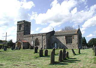
Barmston is a village and civil parish in the East Riding of Yorkshire, England. It is situated on the Holderness coast, overlooking the North Sea and to the east of the A165 road. Barmston is approximately 6 miles (10 km) south of Bridlington town centre. The parish includes the village of Fraisthorpe, the former villages of Auburn and Hartburn have been abandoned due to coastal erosion. Barmston is mentioned in the Domesday Book as having eight ploughlands and belonging to Drogo of la Beuvrière. The name of the village derives from Beorn's Tūn. According to the 2011 UK census, Barmston and Fraisthorpe parish had a population of 275, a slight decrease on the 2001 UK census figure of 277. The parish covering an area of 1,765.014 hectares.

<span class="mw-page-title-main">Brandesburton</span> Village and civil parish in the East Riding of Yorkshire, England

Brandesburton is a village and civil parish in the East Riding of Yorkshire, England. It is situated approximately 7 miles (11 km) west of Hornsea and 9 miles (14 km) north-east of the market town of Beverley.

<span class="mw-page-title-main">Claro Wapentake</span>

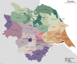
Claro was a wapentake of the West Riding of Yorkshire, England. It was split into two divisions. The Upper Division included the parishes of Farnham, Fewston, Hampsthwaite, Kirkby Malzeard and Pannal and parts of Aldborough, Knaresborough, Otley, Little Ouseburn, Ripley, Ripon, Wetherby and Whixley, many of which formed exclaves. The Lower Division included the parishes of Allerton Mauleverer, Goldsborough, Hunsingore, Kirk Deighton, Kirkby Overblow, Leathley, Spofforth with Stockeld, Weston and parts of Addingham, Aldborough, Harewood, Ilkley, Kirk Hammerton, Otley, Ripley and Whixley.

<span class="mw-page-title-main">Farnham, North Yorkshire</span> Village and civil parish in North Yorkshire, England

Farnham is a village and civil parish in the Harrogate district of North Yorkshire, England. It is situated 2 miles (3.2 km) north of Knaresborough.

<span class="mw-page-title-main">Moor Monkton</span> Village and civil parish in North Yorkshire, England

Moor Monkton is a village and civil parish in the former Harrogate District of North Yorkshire, England. It is situated on the River Nidd and 7 miles (11 km) north-west from York city centre.

<span class="mw-page-title-main">Whixley</span> Village and civil parish in North Yorkshire, England

Whixley is a village and civil parish in the Harrogate district of North Yorkshire, England. It is near the A1(M) motorway and 10 miles (16 km) west of York. The ancient village of Whixley lies on Rudgate, the old Roman road along which the Roman “Hispania” Legion would have marched to nearby Isurium (Aldborough).

<span class="mw-page-title-main">Wauldby</span> Area of the East Riding of Yorkshire, England

Wauldby is a region in the Yorkshire Wolds within the civil parish of Welton in the East Riding of Yorkshire, England. It contains the gentrified hamlet around Wauldby Manor Farm, and a few other minor dwellings including Little Wauldby Farm.

<span class="mw-page-title-main">Dickering Wapentake</span> Former administrative division of Yorkshire, England

Dickering was a wapentake of the historic East Riding of Yorkshire in England, consisting of the north-east part of that county, including the towns of Bridlington and Filey; its territory is now partly in the modern East Riding and partly in North Yorkshire. It was established in 12th or 13th century by combining the three ancient Domesday hundreds of Burton, Huntou (Hunthow) and Torbar. The Wapentake of Dickering ceased to have much significance in the 19th century when the wapentakes were superseded by other administrative divisions for most local government purposes.

<span class="mw-page-title-main">Flixton, North Yorkshire</span> Village in North Yorkshire, England

Flixton is a village in North Yorkshire, England. Until 1974 the village lay in the historic county boundaries of the East Riding of Yorkshire and from 1974 to 2023 it was part of the Borough of Scarborough. There is a public house, the Foxhound Inn.

<span class="mw-page-title-main">Church of All Saints, Skipsea</span> Anglican church in the East Riding of Yorkshire, England

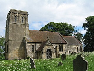
The Church of All Saints, is the church for the village and parish of Skipsea, in the East Riding of Yorkshire, England. The church dates back to the late 11th/early 12th century and was the religious house tied to Skipsea Castle, which lay just to the west in Skipsea Brough. A causeway, to the north of the church, used to link it with the castle motte across what was Skipsea Bail Mere. The village continued developing long after the castle had been demolished c. 1221, and the church became the house of worship for Skipsea.

<span class="mw-page-title-main">Church of St Lambert, Burneston</span> Anglican church in North Yorkshire, England

The Church of St Lambert, Burneston, is the Anglican parish church for the village of Burneston in North Yorkshire, England. The church was built progressively in the 14th, 15th and 16th centuries, with some later additions and is now a grade I listed structure. It is the only Anglican church in England to be dedicated to St Lambert, and one of its former vicars, Canon John Hartley, was noted for being a winner at the Men's Singles championship at Wimbledon two years running.

<span class="mw-page-title-main">Ulshaw Bridge</span> A hamlet in North Yorkshire, England

Ulshaw Bridge is a hamlet on the River Ure, near to Middleham, in North Yorkshire, England. The hamlet derives its name partly from the Medieval stone bridge which spans the River Ure to the immediate south of the hamlet. Ulshaw Bridge is 2.5 miles (4 km) west of Thornton Steward, and 1.25 miles (2 km) east of Middleham.

<span class="mw-page-title-main">Marton cum Grafton</span> Civil parish in North Yorkshire, England

Marton cum Grafton is a civil parish in the Borough of Harrogate of North Yorkshire, England. The parish has only two settlements, and has a magnesian limestone and sandstone geography, which has been used for quarrying. The landform is broadly flat, though there are some small hills with the Marton and Grafton being separated by 98 feet (30 m) despite being only 0.5 miles (0.8 km) apart.

<span class="mw-page-title-main">Whitby Strand</span> Ancient division of North Yorkshire, England

Whitby Strand was a wapentake and liberty in the North Riding of Yorkshire, England. It was one of thirteen wapentakes across the old North Riding of Yorkshire. The division of the area into the Liberty and Wapentake of Whitby Strand occurred in the 14th century, previous to this, the settlements were in the wapentakes of Langbarugh and Pickering Lythe.

<span class="mw-page-title-main">Henderskelfe</span> Civil parish in North Yorkshire, England

Henderskelfe is a civil parish in North Yorkshire, England. The parish does not contain any villages, though it is named after a previous settlement and castle which occupied the land on which Castle Howard is now built. Historically the area was a township in the ecclesiastical parish of Bulmer, however it has been its own civil parish since 1866.

Colden Parva is a former village and ecclesiastical parish of the East Riding of Yorkshire that was lost due to coastal erosion in the 17th century. The name persisted as part of the ecclesiastical parish covering nearby Aldbrough until into the 1970s.

<span class="mw-page-title-main">St John the Baptist's Church, Acklam</span>

St John the Baptist's Church is an Anglican church in Acklam, a village near Malton, North Yorkshire, in England.

References

  1. WCAA 2007, p. 3.
  2. Historic England. "Church of the Ascension (Grade II*) (1189906)". National Heritage List for England . Retrieved 29 December 2023.
  3. "Whixley The Ascension". nationalchurchestrust.org. Retrieved 5 April 2024.
  4. "Whixley | Domesday Book". opendomesday.org. Retrieved 12 April 2024.
  5. Smith, William, ed. (1882). Old Yorkshire. London: Longmans Green & Co. p. 225. OCLC   458976540.
  6. 1 2 "Genuki: Whixley, Yorkshire, England. Further historical information., Yorkshire (West Riding)". genuki.org.uk. Retrieved 12 April 2024.
  7. WCAA 2007, p. 11.
  8. Ryan, W. E. David (2018). English Medieval Church Towers: The Northern Province. Woodbridge: The Boydell Press. p. 140. ISBN   978-1-78327-353-9.
  9. Ingram, M. Edward (1980) [1958]. "Humberside". In Betjeman, John (ed.). Collins guide to parish churches of England and Wales including the Isle of Man (4 ed.). London: Collins. p. 438. ISBN   0-00-216166-4.
  10. Sheahan, James Joseph (1871). History and Topography of the Wapentake of Claro, being a supplementary volume to T. Whellan & Co's. History of York and the North Riding. Beverley: John Green. pp. 329–330. OCLC   776453733.
  11. Sheahan, James Joseph (1871). History and Topography of the Wapentake of Claro, being a supplementary volume to T. Whellan & Co's. History of York and the North Riding. Beverley: John Green. p. 330. OCLC   776453733.
  12. 1 2 Sheahan, James Joseph (1871). History and Topography of the Wapentake of Claro, being a supplementary volume to T. Whellan & Co's. History of York and the North Riding. Beverley: John Green. p. 329. OCLC   776453733.
  13. "St Robert | The Chapel of Our Lady of the Crag". ourladyofthecrag.org. Retrieved 12 April 2024.
  14. Butler, L. A. S., ed. (1990). The Archdeaconry of Richmond in the Eighteenth Century : Bishop Gastrell's 'Notitia' - The Yorkshire Parishes 1714-1725. Cambridge: Cambridge University Press. p. 24. ISBN   978-1-108-06193-3.
  15. "A rambler's scrapbook". Huddersfield Daily Examiner. No. 26, 753. 2 July 1949. p. 5. OCLC   500150503.
  16. Glynne, Stephen (2007). Butler, Laurence (ed.). The Yorkshire Church Notes of Sir Stephen Glynne 18251874. Yorkshire/Suffolk: Yorkshire Archaeological Society/Boydell Press. p. 443. ISBN   978-1-903564-80-6.
  17. Raine, James (1873). "The dedication of Yorkshire churches". Yorkshire Archaeological Journal. 2. Leeds: Yorkshire Archaeological Society: 190. ISSN   0084-4276.
  18. "The restoration of Whixley church". Building News and Architectural Review. 9. London: Building Review: 122. August 1862. OCLC   9974116.
  19. Pevsner, Nikolaus (2003) [1967]. Ratcliffe, Enid (ed.). Yorkshire the West Riding (2 ed.). London: Yale University Press. p. 552. ISBN   0-300-09662-3.
  20. "Church of the Ascension, Whixley". whixley.org. Retrieved 29 December 2023.
  21. "Whixley: The Ascension". achurchnearyou.com. Retrieved 5 April 2024.

Sources