
Lugano is a city and municipality in Switzerland, part of the Lugano District in the canton of Ticino. It is the largest city of both Ticino and the Italian-speaking southern Switzerland. Lugano has a population of 62,315, and an urban agglomeration of over 150,000. It is the ninth largest Swiss city.
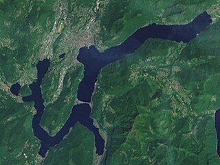
Lake Lugano is a glacial lake which is situated on the border between southern Switzerland and northern Italy. The lake, named after the city of Lugano, is situated between Lake Como and Lago Maggiore. It was cited for the first time by Gregory of Tours in 590 with the name Ceresio, a name which is said to have derived from the Latin word cerasus, meaning cherry, and refers to the abundance of cherry trees which at one time adorned the shores of the lake. The lake appears in documents in 804 under the name Laco Luanasco.

The Asiago Astrophysical Observatory is an Italian astronomical observatory owned and operated by the University of Padua. Founded in 1942, it is located on the plateau of Asiago, 90 kilometers northwest of Padua, near the town of Asiago. Its main instrument is the 1.22-meter Galilei telescope, currently used only for spectrometric observations.

Radiotelevisione svizzera di lingua italiana is a Swiss public broadcasting organisation, part of SRG SSR. RSI handles production and broadcasting of radio and television programs in Italian and Lombard for Switzerland. RSI's administrative headquarters are located in Via Canevascini in Lugano-Besso.

Camporosso is a comune (municipality) in the Province of Imperia in the Italian region Liguria, located about 160 kilometres (99 mi) southwest of Genoa and about 45 kilometres (28 mi) west of Imperia.

San Biagio della Cima is a comune (municipality) in the Province of Imperia in the Italian region Liguria, located about 120 kilometres (75 mi) southwest of Genoa and about 30 kilometres (19 mi) west of Imperia.
Vallebona is a comune (municipality) in the Province of Imperia in the Italian region Liguria, located about 120 kilometres (75 mi) southwest of Genoa and about 30 kilometres (19 mi) west of Imperia. Vallebona borders the following municipalities: Bordighera, Ospedaletti, Perinaldo, San Biagio della Cima, Seborga, Soldano, and Vallecrosia.

Vallecrosia is a comune (municipality) in the Province of Imperia in the Italian region Liguria, located about 120 kilometres (75 mi) southwest of Genoa and about 30 kilometres (19 mi) west of Imperia. It is next to the busy city of Ventimiglia.

Porlezza is a comune (municipality) on Lake Lugano in the Province of Como in the Italian region Lombardy, located about 60 kilometres (37 mi) north of Milan and about 25 kilometres (16 mi) north of Como.

Monte Generoso is a mountain of the Lugano Prealps, located on the border between Switzerland and Italy and between Lake Lugano and Lake Como. The western and southern flanks of the mountain lie in the Swiss canton of Ticino, whilst the north-eastern flanks are in the Italian region of Lombardy.
The Cima di Jazzi is a mountain of the Pennine Alps, located on the Swiss-Italian border, just north of Monte Rosa. It overlooks Macugnaga on its east (Italian) side. The west (Swiss) side is entirely covered by glaciers.

Cima di Castello is a mountain of the Bregaglia Range, located on the border between Italy and Switzerland. With a height of 3,379 metres (11,086 ft) above sea level, it is the second highest mountain in the Bregaglia Range. Its summit lies between the valleys of the Albigna and Forno Glacier and the valley of Val Mello.
The Motto della Tappa is a mountain of the Lugano Prealps, located on the Swiss-Italian border.

Monte Tamaro is a mountain of the Lugano Prealps, overlooking Lake Maggiore in the Swiss canton of Ticino. Reaching a height of 1,962 metres above sea level, it is the highest summit of the chain located between Lake Maggiore and Lake Lugano, which also includes Monte Lema. It is also the most prominent summit of the canton.
Cima di Piancabella is a mountain of the Swiss Lepontine Alps, overlooking Malvaglia in the canton of Ticino. It is located south of the Cima di Gana Bianca.

The Cima Ekar Observing Station is an astronomical observatory on the crest of Cima Ekar, a mountain ridge located approximately 4 kilometers southeast of and 350 m higher than the town of Asiago, Italy.

The Val Colla is a valley and a quarter of the city of Lugano in the Swiss canton of Ticino, to the north-east of the city of Lugano. It includes the localities of Bogno, Valcolla, Certara, Cimadera, Sonvico, which are all part of the city of Lugano, and the municipality of Capriasca.
The Swiss Customs Museum, or Museo doganale svizzero, is a museum located in the Swiss canton of Ticino. The museum is sited near Cantine di Gandria, directly across the Lake Lugano from the village of Gandria, and adjacent to the border with Italy. The museum was formerly a border post on that border, but now forms part of the Swiss National Museum.
The Corno di Gesero is a mountain of the Lepontine Alps, located on the border between the Swiss cantons of Ticino and Graubünden. It lies on the range west of the Cima di Cugn, between the Valle d'Arbedo and the Val Traversagna.

The border between the modern states of Switzerland and Italy extends for 744 kilometres (462 mi), from the French-Swiss-Italian tripoint at Mont Dolent in the west to the Austrian-Swiss-Italian tripoint near Piz Lad in the east. Much of the border runs across the High Alps, rising above 4,600 metres (15,100 ft) as it passes east of Dufourspitze, but it also descends to the lowest point in Switzerland as it passes Lago Maggiore at below 200 metres (660 ft).

