Cime de Missun

Last updated
Cime de Missun
Italian: Cima Missun
Cima Missun from NW.png
Highest point
Elevation 2,355 m (7,726 ft) [1]
Prominence 183 m (600 ft) [1] [2]
Coordinates 44°06′00″N7°41′43″E / 44.0999°N 7.6953°E / 44.0999; 7.6953 Coordinates: 44°06′00″N7°41′43″E / 44.0999°N 7.6953°E / 44.0999; 7.6953
Geography
Alps location map.png
Red triangle with thick white border.svg
Cime de Missun
Location in the Alps
Location Piemonte, Italy -
Provence-Alpes-Côte d'Azur, France
Parent range Ligurian Alps
Climbing
First ascent ancestral
Easiest route foothpath

The Cime de Mussun (French) or Cima Missun (Italian [3] ) is a mountain of the Ligurian Alps.

Contents

History

View from Monte Bertrand Cima Missun and Colla Rossa from Monte Bertrand.png
View from Monte Bertrand

The mountain up to World War II was totally belonging to Italy but, following the Paris Peace Treaties, signed in February 1947, is now shared between Italy and France. [4]

Geography

Summit cross Cima Missun summit cross background Monte Bertrand.png
Summit cross

The mountain belongs to the Ligurian Alps and is located on the main chain of the Alps and on the water divide between che drainage basins of river Po (East) and Roya. Heading South the chain goes on with Punta Farenga and Cima Ventosa, while towards N-W it continues with the large saddle of Colla Rossa , which divides Cima Missun from Monte Bertrand. [5] The summit, which is marked by a small cross, is located in France close to the French-Italian border, between Piemonte and Provence-Alpes-Côte d'Azur. Administratively the summit belongs to the French mairie of La Brigue. On the slopes facing Italy a former military mule-track runs across the mountainside, connecting Monesi with the colle di Tenda.

SOIUSA classification

According to the SOIUSA (International Standardized Mountain Subdivision of the Alps) the mountain can be classified in the following way: [6]

Hiking

Panorama from the summit View from Cima Missun.png
Panorama from the summit

The mountain is accessible from the Colla Rossa [7] by a brief diversion branching from the former military dirt road which marks the border between Italy and France, which in this stretch coincides with an hiking itinerary named Alta via delle Alpi del Mare. [8]

Maps

Related Research Articles

Monte Frontè Mountain in Italy

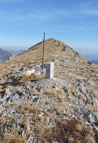
Monte Frontè is a mountain in Liguria, northern Italy, part of the Alps. It is located in the province of province of Imperia. It lies at an altitude of 2,152 metres. After Monte Saccarello it is the second highest peak in the Ligurian region.

Monte Saccarello Mountain in Italy

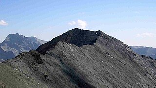
Monte Saccarello (Italian) or Mont Saccarel (French) is a mountain located on the French-Italian border between Liguria, Piedmont and Provence-Alpes-Côte d'Azur.

Monte Settepani Mountain in Italy

Monte Settepani is 1,386 metres high mountain in Liguria, northern Italy, part of the Ligurian Alps.

Pointe de Paumont Mountain in Italy

Pointe de Paumont or Cima del Vallone is a mountain of Savoie, France and of the Province of Turin, Italy. It lies in the Cottian Alps range. It has an elevation of 3,171 metres above sea level.

Cima Garlenda Mountain in Italy

Cima Garlenda is a 2,141 m (7,024 ft) mountain of the Ligurian Alps, in Italy. After Monte Saccarello and Monte Frontè it is the third Ligurian summit.

Monte Tanarello Mountain in Italy

Monte Tanarello (Italian) or Mont Tanarel (French) is a 2094 metres high mountain located on the French-Italian border.

Cima di Pertegà Mountain in Italy

Cima di Pertegà (Italian) or Cime de la Pertègue (French) is a mountain located on the French-Italian border between Piemonte and Provence-Alpes-Côte d'Azur.

Cime de Capoves Mountain in Italy

The Cime de Capoves (French) or Cima Capoves (Italian) is a mountain of the Ligurian Alps located in the French region of Provence-Alpes-Côte d'Azur, close to the French-Italian border.

Monte Monega Mountain in Italy

Monte Monega is a 1,882-metre (6,175 ft) mountain of the Ligurian Alps, in Italy.

Carmo di Brocchi Mountain in Italy

Carmo di Brocchi is a 1,610-metre (5,282 ft) mountain of the Ligurian Alps, in Italy.

Monte Bertrand Mountain in Italy

Monte Bertrand (Italian) or Mont Bertrand (French) is a mountain located on the French-Italian border between Piemonte and Provence-Alpes-Côte d'Azur.

Bric Costa Rossa Mountain in Italy

The Bric Costa Rossa is a mountain of the Ligurian Alps located in Piedmont.

Cima della Fascia Mountain in Italy

The Cima della Fascia is a mountain of the Ligurian Alps located in Piedmont.

Monte Mongioie Mountain in Italy

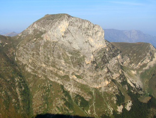
The Monte Mongioie is a mountain of the Ligurian Alps located in Piedmont.

Monte Antoroto Mountain in Italy

The Monte Antoroto is a mountain of the Ligurian Alps located in Piedmont.

Cima delle Saline Mountain in Italy

The Cima delle Saline is a mountain of the Ligurian Alps located in Piedmont.

Punta Mirauda Mountain in Italy

The Punta Mirauda is a mountain of the Ligurian Alps located in Piedmont.

Monte Cianea Mountain in Italy

Monte Cianea is a 1,226-metre (4,022 ft) mountain of the Ligurian Alps, in Italy.

Cima Cars Mountain in Italy

The Cima Cars is a mountain of the Ligurian Alps located in Piedmont.

Monte Fantino Mountain in Italy

The Monte Fantino is a mountain of the Ligurian Alps located in Piedmont.

References

  1. 1 2 carta in scala 1:25.000 n.16 "Parco del Marguareis" (Map). Ciriè: Fraternali.
  2. Key col: Colla Rossa (2172 m)
  3. "L'Universo" (in Italian). Vol. 28. Istituto Geografico Militare. 1948. p. 10. Retrieved 2019-07-15.
  4. Trattato di pace tra Italia ed Alleati, treaty text on www.instoria.it (access-date: 2019-07-14)
  5. Carta dei sentieri e stradale 1:25.00 Alta Val Tanaro, Alta Valle Arroscia, Alta Valle Argentina (Map) (in Italian). Ciriè: Fraternali.
  6. Marazzi, Sergio (2005). Atlante Orografico delle Alpi. SOIUSA (in Italian). Priuli & Verlucca. p. 62. ISBN   978-88-8068-273-8.
  7. settecapelli Andrea81 (2011-11-26). "Missun (Cima) dal Ponte del Giairetto per la Colla Rossa" (in Italian). Retrieved 2018-07-05.
  8. "AM.11 Rifugio Don Barbera - Colla Rossa - Rifugio Sanremo" (in Italian). Retrieved 2018-07-05.

See also

Commons-logo.svg Media related to Cime Missoun at Wikimedia Commons