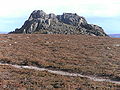
The Cuillin is a range of rocky mountains located on the Isle of Skye in Scotland. The main Cuillin ridge is also known as the Black Cuillin to distinguish it from the Red Cuillin, which lie to the east of Glen Sligachan.

Kincardineshire, also known as the Mearns, is a historic county, registration county and lieutenancy area on the coast of northeast Scotland. It is bounded by Aberdeenshire on the north and west, and by Angus on the south.

Banchory is a burgh or town in Aberdeenshire, Scotland. It is about 18 miles (29 km) west of Aberdeen, near where the Feugh River meets the River Dee.

The Mounth is the broad upland in northeast Scotland between the Highland Boundary and the River Dee, at the eastern end of the Grampians.

The Grampian Mountains are one of the three major mountain ranges in Scotland, occupying a considerable portion of the Scottish Highlands in northern Scotland. The other major mountain ranges in Scotland are the Northwest Highlands and the Southern Uplands. The Grampian range extends southwest to northeast between the Highland Boundary Fault and the Great Glen, occupying almost half of the land area of Scotland and including the Cairngorms and the Lochaber hills. The range includes many of the highest mountains in the British Isles, including Ben Nevis and Ben Macdui.

Kincardine and Mearns is one of six area committees of the Aberdeenshire council area in Scotland. It has a population of 38,506. There are significant natural features in this district including rivers, forests, mountains and bogs.

Cairn O' Mounth/Cairn O' Mount is a high mountain pass in Aberdeenshire, Scotland. The place name is a survival of the ancient name for what are now the Grampian Mountains, earlier called "the Mounth". The name change happened from circa 1520 AD. The Ordnance Survey shows the name as Cairn o' Mount.

Bynack More is a Scottish Mountain that is situated in the Cairngorms range, 16 kilometres east-south-east of the town of Aviemore in the Highland region.

The Deeside Way is a 41-mile (66 km) rail trail that follows, in part, the bed of the former Deeside Railway in Aberdeenshire. Forming part of the National Cycle Network the trail leads from Aberdeen to Ballater.
Blelack is a place in Aberdeenshire, Scotland, the location of Blelack House, a Scottish mansion house with origins in the seventeenth century.

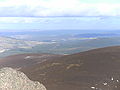
Scolty Hill is a small hill south of the Deeside town, Banchory. Its best known feature is the 20m tall tower monument, built in 1840 as a memorial to General William Burnett who fought alongside Wellington. The tower was restored in 1992 and a viewing platform added by the Rotary Club of Banchory-Ternan. It enjoys splendid views over Banchory, the Dee Valley and the Grampian Mountains, which surround the hill. This encourages thousands of visitors each year. It is popular for tourists, locals and mountain bikers.
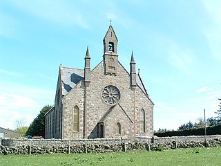
Cookney is a hamlet in Aberdeenshire, Scotland in proximity to Netherley in the Mounth of the Grampian Highlands. The community is situated on a hilltop approximately 5 miles (8 km) northwest of Stonehaven, about 3 miles (5 km) northwest of the Bridge of Muchalls, and about 2 miles (3 km) west of Muchalls Castle. From Cookney a portion of the ancient route of the Causey Mounth is visible to the east near Whinward Farm, although the track is not truly recognizable from that distance. The Cookney Church is a prominent historic landmark of Cookney.

Banchory-Devenick is a village approximately two kilometres south of the city of Aberdeen, Scotland in the Lower Deeside area of Aberdeenshire. The village should not be confused with the historic civil parish of the same name which spanned the River Dee until 1891, its northern part lying in Aberdeenshire and its southern part in Kincardineshire. In that year the northern part became part of the neighbouring parish of Peterculter, the southern part remaining as the parish of Banchory-Devenick. The village of Banchory-Devenick is on the B9077 road, and the ancient Causey Mounth passes directly through the village. An historic graveyard dating to 1157 AD is present at the village of Banchory-Devenick. Other historic features in the vicinity include Saint Ternan's Church, Muchalls Castle and the Lairhillock Inn.
Kempstone Hill is a landform in Aberdeenshire, Scotland within the Mounth Range of the Grampian Mountains. The peak elevation of this mountain is 132 metres above mean sea level. This hill has been posited by Gabriel Jacques Surenne, Archibald Watt and C.Michael Hogan as the location for the noted Battle of Mons Graupius between the Romans and the indigenous Caledonians. The major Roman Camp of Raedykes is situated about three kilometres to the west. From Kempstone Hill there are fine views to the North Sea facing east and slightly to the north of Muchalls Castle. There is a UK trigpoint installation on Kempstone Hill.
Megray Hill is a low-lying coastal mountainous landform in Aberdeenshire, Scotland within the Mounth Range of the Grampian Mountains. The peak elevation of this mountain is 120 metres above mean sea level. This hill has been posited as a likely location for the noted Battle of Mons Graupius between the Romans and the indigenous Caledonians. The major Roman Camp of Raedykes is situated about three kilometres to the west. From Megray Hill there are expansive views to the North Sea facing east. The summit affords scenic views of the historic harbour of Stonehaven.

Creise is a Scottish mountain that stands at the eastern end of Glen Coe, just to the south of the A82 road, some 26 kilometres South-southeast of Fort William in the Highland Council area. The mountain was previously known as Clach Leathad in the Munro Tables prior to 1981, its name being changed to Creise when the highest point was found to be 1200 metres further north along the summit ridge when using new mapping techniques.
Cookney Parish Church, now business premises within a converted listed building, was a Christian place of worship in the village of Cookney, Aberdeenshire, Scotland.

Balfour, Aberdeenshire is a settlement on Royal Deeside in Aberdeenshire, Scotland. Balfour lies south of the River Dee.
Lower Deeside is a region along the River Dee in Aberdeenshire, Scotland. The boundaries of this area are subject to interpretation, since the usage has altered through historic times; however, the area is generally associated with the communities of Durris, Maryculter and Banchory-Devenick in the historic district of Kincardineshire.