Schonchin Butte is a cinder cone on the northern flank of Medicine Lake Volcano in the Cascade Range in northern California. Frothy lava, cooled in the air, created the large cinder cones throughout Lava Beds National Monument. It is named for Old Schonchin, a chief of the Modoc people during the late nineteenth century. Erupting more than 30,000 years ago, the volcano spewed ash and cinders into the air much like a can of soda when shaken. A lava spatter rampart is at the very top.

Mount Adams, known by some Native American tribes as Pahto or Klickitat, is a potentially active stratovolcano in the Cascade Range. Although Adams has not erupted in more than 1,000 years, it is not considered extinct. It is the second-highest mountain in Washington, after Mount Rainier.

This is a list of properties and historic districts in Montana that are listed on the National Register of Historic Places. The state's more than 1,100 listings are distributed across all of its 56 counties.

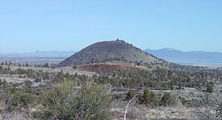
Lava Butte is a cinder cone in central Oregon, United States, just west of U.S. Route 97 between the towns of Bend, Oregon, and Sunriver, Oregon. It is part of a system of small cinder cones on the northwest flank of Newberry Volcano, a massive shield volcano which rises to the southeast. The cinder cone is capped by a crater which extends about 60 feet (20 m) deep beneath its south rim, and 160 feet (50 m) deep from the 5,020-foot (1,530 m) summit on its north side. Lava Butte is part of the Newberry National Volcanic Monument.

The historical Winchester Lookout, located in the North Cascades in the U.S. state of Washington, provides views of the Northern Picket Range, Mount Baker, Mount Shuksan, Mount Larrabee, and Canadian peaks. The steep snowfields usually require an ice-axe well into July. The Twin Lakes road may not be passable to the trailhead which will add 2 miles (3.2 km) to the hike. Volunteers from the Mount Baker Club maintain the lookout with 2 work parties per year.

Pelican Butte is a steep-sided dormant shield volcano in the Cascade Range of southern Oregon. It is located 28 miles (45 km) due south of Crater Lake and 12 miles (19 km) northeast of Mount McLoughlin, and rises over 3,800 feet (1,200 m) directly above the shore of Upper Klamath Lake. Ice Age glaciers carved a large cirque into the northeast flank of the mountain, forming a steep bowl which is popular in winter with backcountry skiers and snowmobilers. Several proposals have been made over the last few decades for ski area development on the northeast flanks, but none of the proposals has obtained the regulatory approval from the United States Forest Service necessary to proceed with construction. If the ski area is ever built, its skiable vertical of over 3,800 feet (1,200 m) would be the largest in Oregon exceeding the 3,590 feet (1,090 m) of Timberline Lodge ski area on Mount Hood.

The Watchman Lookout Station No. 168 is one of two fire lookout towers in Crater Lake National Park in southern Oregon. For many years, National Park Service personnel used the lookout to watch for wildfires during the summer months. It is also a common hiking destination because of its views of Crater Lake and the surrounding area. The building is unusual because it serves the dual purpose of fire lookout and museum. The Watchman Lookout Station is listed on the National Register of Historic Places.

The Imnaha Guard Station is a rustic cabin located in the Rogue River-Siskiyou National Forest in western Oregon, United States. It was originally built to house fire crews assigned to patrol the surrounding National Forest. In the 1990s, the United States Forest Service began renting the Imnaha Guard Station to recreational visitors. The Imnaha Guard Station is listed on the National Register of Historic Places.

This is a list of the National Register of Historic Places listings in Chelan County, Washington.

The Huckleberry Mountain Fire Overlook is a fire lookout station in northern Bridger-Teton National Forest. The rustic two-story log structure was built in 1938 by the Civilian Conservation Corps to a standard U.S. Forest Service design. The lookout was used for fire surveillance until 1957.
The Rosencrans Cabin is part of a small historic district comprising five log buildings on three acres in Bridger-Teton National Forest, just east of Grand Teton National Park. The cabin was used by Rudolph "Rosie" Rosencrans, who played a role in the development of Teton National Forest and who later became a U.S. Forest Service administrator in the early 20th century. Rosencrans was buried at this location.

The Huckleberry Fire Lookout in Glacier National Park is significant as one of a chain of manned fire lookout posts within the park. The low two-story timber-construction structure with a pyramidal roof was built in 1933, replacing a similar structure built in 1923. It is one of several similar structures built to a modified version of a plan developed by the U.S. Forest Service.

The Mount Brown Fire Lookout in Glacier National Park is significant as one of a chain of manned fire lookout posts within the park. The low two-story timber-construction structure with a pyramidal roof was built in 1928. The design was a standard U.S. Forest Service plan.
The Willow Prairie Cabin is a rustic one-room cabin located in the Rogue River-Siskiyou National Forest in western Oregon, United States. It was built by a road construction crew in 1924. When the road was finished the United States Forest Service began using it to house fire crews assigned to patrol the surrounding National Forest. The Forest Service now rents the cabin to recreational visitors. The Willow Prairie Cabin is listed on the National Register of Historic Places.

The Rawhide Buttes Stage Station, the Running Water Stage Station and the Cheyenne-Black Hills Stage Route comprise a historic district that commemorates the stage coach route between Cheyenne, Wyoming and Deadwood, South Dakota. The route operated beginning in 1876, during the height of the Black Hills Gold Rush, and was replaced in 1887 by a railroad.
The Jack Creek Guard Station is a ranger patrol cabin in Medicine Bow National Forest in Carbon County, Wyoming. The one-room log cabin was built by U.S. Forest Service district ranger Evan John Williams in 1933-34. It was built to Forest Service Plan A-4, featuring half-dovetailed corners and a deep front porch with a gabled wood shake roof. A stove is vented through a brick chimney at the back of the cabin.

The James T. Saban Lookout, also known as the High Park Lookout, is a fire lookout tower located in Bighorn National Forest near Ten Sleep, Wyoming in Washakie County, Wyoming. It was listed on the National Register of Historic Places in 2016.

The Los Burros Ranger Station is a forest ranger station situated in Apache County, Arizona. The station was manned by rangers who traveled to the nearby Lake Mountain Lookout.

The McCart Fire Lookout, near Sula, Montana, was built in 1939. It was listed on the National Register of Historic Places in 1996.


