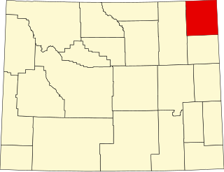
This is intended to be a complete list of the properties and districts on the National Register of Historic Places in Park County, Wyoming, United States. The locations of National Register properties and districts for which the latitude and longitude coordinates are included below, may be seen in a map.[1]
There are 43 properties and districts listed on the National Register in the county, six of which are National Historic Landmarks.
Dude ranch established in 1917, with 15 contributing properties; an operational and nearly intact example of a local business model spurred by the rise of middle-class auto tourism.[5]
One of Wyoming's oldest and most moved buildings, constructed in 1841 in LeClaire, Iowa, and brought to the first of three locations in Cody in 1933 as a tourist attraction. Now on the grounds of the Buffalo Bill Center of the West.[8]
One of the nation's first two gravity-arch dams, built 1905–1910 under challenging conditions for the Shoshone Project, a pioneering federal effort to boost the settlement capacity of the arid American West.[9]
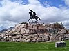
1924 equestrian statue of Buffalo Bill by Gertrude Vanderbilt Whitney, a latter-day subject in the Euro-American tradition of artworks commemorating white explorers and frontiersmen.[10]
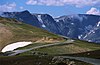
Geothermal area (now largely dormant) encountered by explorer and mountain man John Colter (c.1770–c. 1812) in 1807; the first definitive place in Wyoming described by a Euro-American.[12]
Archaeological site with multiple cultural assemblages spanning 4,500 years, with numerous stone and bone tools, a wide variety of faunal remains, and deer antlers placed in a rock cairn.[14]
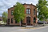
Small commercial district representing the prosperity achieved by Cody and the surrounding region at the turn of the 20th century, with 20 contributing properties built 1900–1930s.[15]
Headquarters complex and remote patrol cabins built during the initial administration of Yellowstone by the U.S. Army 1886–1918, establishing policies and procedures that influenced subsequent conservation and national park management. Extends into Teton County; Park County, Montana; and Fremont County, Idaho.[18]
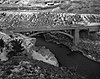
The nation's first large planned park road system, developed 1872–1905 in challenging conditions by the Army Corps of Engineers under Hiram M. Chittenden (1858–1917). Comprises 140 miles (230km) and nine 1930s bridges harmonized to the setting.[20]
Site of a federal concentration camp for the internment of Japanese Americans 1942–1945, where some internees conducted the largest single draft resistance effort in U.S. history. Contains five contributing properties and an interpretive center.[22]
Site where Paleo-Indians processed bison for at least a thousand years, showing a variety of stone tools types in contemporaneous use; type site for the Cody complex.[24]
Hotel established by Buffalo Bill Cody in 1902 as a first-class amenity and social center for his anticipated influx of wealthy vacationers, investors, and regional businessmen.[25] Also a contributing property to the Downtown Cody Historic District.[15]
Five-building complex used for bison management 1907–1952, initially under cattle ranching methods, illustrating bison conservation, the evolution of wildlife management practices, and changing park ranger duties.[26]
Yellowstone National Park's longstanding administrative and concession headquarters, with 192 contributing properties built 1891–1948. Associated with the development of the park and national park policies in general, the New Deal, and numerous architectural styles.[27]
Unusually dry and well stratified rock shelter occupied from the late Paleoindian to the Late Prehistoric period, preserving rare organic artifacts and a high-status human burial.[29]
Three trailside museums and a staff residence built 1929–1931, whose National Park Service rustic architecture was a major influence on buildings in national, state, and county parks around the U.S. during the New Deal.[31]
Pivotal Native American quarrying site for obsidian tools and ceremonial objects traded throughout the North American interior for 11,500 years. Also a key site in the development of geochemical analysis of lithic artifacts.[33]
Buffalo Bill Cody's 1901 hotel and hunting lodge, an influence on the development of Yellowstone's east entrance road and on the conservation ideas of his prestigious private guests.[37]
60-mile (97km) scenic federal highway built 1931–1936 in challenging alpine conditions. Better known as the Beartooth Highway, it extends into Carbon and Park County, Montana.[40]
Rustic lodge and cabin complex with 124 contributing properties built 1919–1938, associated with the park's early educational programs and development of accommodations for middle-class automobile tourists.[42]
Four-building residence constructed 1945–46 by Paul Stock (1894–1972), a pioneer in the Wyoming oil industry, three-time mayor of Cody, and philanthropist.[44]
1937 post office, one of five in Wyoming with Section of Painting and Sculpture artwork, symbolizing the extensive New Deal public works and federal presence benefiting small communities.[46]
Operational and highly intact dude ranch established in 1929, with 11 contributing properties; representing local entrepreneurship upon the rise of middle-class auto tourism.[48]
The Norris Geyser Basin Museum, also known as Norris Museum, is one of a series of "trailside museums" in Yellowstone National Park designed by architect Herbert Maier in a style that has become known as National Park Service Rustic. It is listed on the National Register of Historic Places, and is one of three parts of a National Historic Landmark, the Norris, Madison, and Fishing Bridge Museums, which were funded by Laura Spelman Rockefeller's grant of $118,000. Built 1929 - 1930, the Norris Museum is sited on a hill between the Porcelain Basin and the Back Basin of Norris Geyser Basin. Its central breezeway frames a view of the Porcelain Basin for arriving visitors.
The Madison Museum is one of a series of "trailside museums" in Yellowstone National Park designed by architect Herbert Maier in a style that has become known as National Park Service Rustic. It was listed on the National Register of Historic Places in 1982, and is one of three parts of a 1987-declared National Historic Landmark, the Norris, Madison, and Fishing Bridge Museums. Built in 1929, the Madison Museum is the smallest of the three. It is sited on a small rise that overlooks the meadows and canyon of the Madison River, and still fulfills its function as an informal interpretive center.
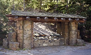
The Obsidian Cliff Kiosk is a small structure that shelters an interpretive exhibit in Yellowstone National Park at Obsidian Cliff. The kiosk was built in 1931 as part of an effort to provide interpretive exhibits along the park's Grand Loop Road. In common with the Fishing Bridge Museum, Madison Museum and Norris Museum, the kiosk exemplifies the National Park Service Rustic style. The interpretive exhibit was designed by National Park Service's Carl Russell, who provided many other innovations in visitor experiences.
The Roosevelt Lodge Historic District comprises the area around the Roosevelt Lodge in the northern part of Yellowstone National Park, near Tower Junction. The district includes 143 buildings ranging in size from cabins to the Lodge, built beginning in 1919. The Lodge was first conceived as a field laboratory for students and educators conducting research in the park. It later became a camp for tourists, specifically designed to accommodate automobile-borne tourists. The Lodge is a simplified version of the National Park Service Rustic style.
The Mammoth Hot Springs Historic District is a 158-acre (64 ha) historic district in Yellowstone National Park comprising the administrative center for the park. It is composed of two major parts: Fort Yellowstone, the military administrative center between 1886 and 1918, and now a National Historic Landmark, and a concessions district which provides food, shopping, services, and lodging for park visitors and employees. It was added to the National Register of Historic Places on March 20, 2002, for its significance in architecture, conservation, entertainment/recreation, and military. The district includes 189 contributing buildings.
The North Entrance Road Historic District comprises Yellowstone National Park's North Entrance Road from Gardiner, Montana to the park headquarters at Mammoth Hot Springs, Wyoming, a distance of a little over five miles (8 km). The North Entrance Road was the first major road in the park, necessary to join the U.S. Army station at Fort Yellowstone to the Northern Pacific Railroad station at Gardiner. The road includes the Roosevelt Arch at the northern boundary of the park and winds through rolling terrain before crossing the Gardner River and joining the Grand Loop Road.
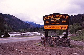
The Absaroka Mountain Lodge is a historic dude ranch located between Cody, Wyoming, and Yellowstone National Park in the Absaroka Mountains. The property in Shoshone National Forest was known as the Gunbarrel Lodge when it was established about 1917 by Earl F. Crouch. It received its enduring name in 1925, and was progressively expanded until the 1970s.
This is a list of the National Register of Historic Places listings in Crow Wing County, Minnesota. It is intended to be a complete list of the properties and districts on the National Register of Historic Places in Crow Wing County, Minnesota, United States. The locations of National Register properties and districts for which the latitude and longitude coordinates are included below, may be seen in an online map.
This is a list of the National Register of Historic Places listings in Olmsted County, Minnesota. It is intended to be a complete list of the properties and districts on the National Register of Historic Places in Olmsted County, Minnesota, United States. The locations of National Register properties and districts for which the latitude and longitude coordinates are included below, may be seen in an online map.
The UXU Ranch is a historic dude ranch in Shoshone National Forest near Wapiti, Wyoming. The ranch began as a sawmill, as early as 1898. In 1929 Bronson Case "Bob" Rumsey obtained a permit from the U.S. Forest Service to operate a dude ranch on the property, using the sawmill headquarters building, a lodge, and tent cabins. Most of the current structures were built in the 1920s and 1930s from lumber milled on the site.
The Red Star Lodge and Sawmill, also known as the Shoshone Lodge, is a dude ranch in Shoshone National Forest near the east entrance to Yellowstone National Park. Built between 1924 and 1950, the ranch includes a rustic log lodge surrounded by cabins and support buildings. What is now called the Shoshone Lodge is the most intact example of a dude ranch operation in the area.
This is a list of the National Register of Historic Places listings in Cass County, Minnesota. It is intended to be a complete list of the properties and districts on the National Register of Historic Places in Cass County, Minnesota, United States. The locations of National Register properties and districts for which the latitude and longitude coordinates are included below, may be seen in an online map.
This is a list of the properties and districts on the National Register of Historic Places in Cook County, Minnesota, United States. The locations of National Register properties and districts for which the latitude and longitude coordinates are included below, may be seen in an online map.
This is a list of the National Register of Historic Places listings in Big Horn County, Wyoming.
This is a list of the National Register of Historic Places listings in Crook County, Wyoming.
This is a list of the National Register of Historic Places listings in Johnson County, Wyoming. It is intended to be a complete list of the properties and districts on the National Register of Historic Places in Johnson County, Wyoming, United States. The locations of National Register properties and districts for which the latitude and longitude coordinates are included below, may be seen in an online map.
This is a list of the National Register of Historic Places listings in Washakie County, Wyoming. It is intended to be a complete list of the properties and districts on the National Register of Historic Places in Washakie County, Wyoming, United States. The locations of National Register properties and districts for which the latitude and longitude coordinates are included below, may be seen in a map.
This is a list of the National Register of Historic Places listings in Weston County, Wyoming. It is intended to be a complete list of the properties and districts on the National Register of Historic Places in Weston County, Wyoming, United States. The locations of National Register properties and districts for which the latitude and longitude coordinates are included below, may be seen in a map.
This is a list of the National Register of Historic Places listings in Yellowstone National Park.
References
↑ The latitude and longitude information provided in this table was derived originally from the National Register Information System, which has been found to be fairly accurate for about 99% of listings. Some locations in this table may have been corrected to current GPS standards.
1 2 Numbers represent an alphabetical ordering by significant words. Various colorings, defined here, differentiate National Historic Landmarks and historic districts from other NRHP buildings, structures, sites or objects.
↑ The eight-digit number below each date is the number assigned to each location in the National Register Information System database, which can be viewed by clicking the number.
This page is based on this Wikipedia article Text is available under the CC BY-SA 4.0 license; additional terms may apply. Images, videos and audio are available under their respective licenses.