Related Research Articles

The Lamoka site, or simply Lamoka, is an archaeological site near Tyrone, in Schuyler County, New York that was named a National Historic Landmark in 1961. According to the National Park Service, "This site provided the first clear evidence of an Archaic hunting and gathering culture in the Northeastern United States ".

The Hagen Site, also designated by the Smithsonian trinomial 24DW1, is an archaeological site near Glendive in Dawson County, Montana. The site, excavated in the 1930s, is theorized to represent a rare instance of a settlement from early in the period in which the Crow and Hidatsa Native American tribes separated from one another. It was declared a National Historic Landmark in 1964.

The Gallagher Flint Station Archeological Site is an archaeological site and National Historic Landmark in northern Alaska. Discovered in 1970 during the construction of the Trans-Alaska Pipeline, it yielded a radiocarbon date of 10,540 B.P., making it the oldest site of human activity then known in the state.

This is a list of the National Register of Historic Places listings in Albany County, Wyoming. It is intended to be a complete list of the properties and districts on the National Register of Historic Places in Albany County, Wyoming, United States. The locations of National Register properties and districts for which the latitude and longitude coordinates are included below, may be seen in a map.

This is a list of the National Register of Historic Places listings in Big Horn County, Wyoming.
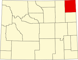
This is a list of the National Register of Historic Places listings in Crook County, Wyoming.

This is a list of the National Register of Historic Places listings in Carbon County, Wyoming.

This is a list of the National Register of Historic Places listings in Lincoln County, Wyoming.

This is a list of the National Register of Historic Places listings in Park County, Wyoming.

This is a list of the National Register of Historic Places listings in Converse County, Wyoming.

This is a list of the National Register of Historic Places listings in Uinta County, Wyoming.

This is a list of the National Register of Historic Places listings in Campbell County, Wyoming. It is intended to be a complete list of the properties and districts on the National Register of Historic Places in Campbell County, Wyoming, United States. The locations of National Register properties and districts for which the latitude and longitude coordinates are included below, may be seen in a map.
The Dead Indian Campsite is an archeological site in the Sunlight Basin of the Absaroka Mountains in Park County, Wyoming, United States. The site was found during the construction of the Sunlight Basin Road in 1967. The location was used as a butchering site, and excavations by the University of Wyoming in 1969 uncovered numerous stone tools, as well as the bones of elk, deer, mountain sheep, porcupine and wolf. A stone cairn was found to contain antler sets. The site was used in different eras for 4500 years.

Mummy Cave is a rock shelter and archeological site in Park County, Wyoming, United States, near the eastern entrance to Yellowstone National Park. The site is adjacent to the concurrent U.S. Routes 14/16/20, on the left bank of the North Fork of the Shoshone River at an altitude of 6,310 feet (1,920 m) in Shoshone National Forest.

The Vore Buffalo Jump is an archeological site in Crook County, Wyoming. A sinkhole formed where gypsum soil was eroded, leaving a steep-sided pit about 40 feet (12 m) deep and 200 feet (61 m) in diameter. Native American hunters could stampede bison in the direction of the pit, which was deep enough to kill or disable the animals that were driven into it. The location is one of a number of buffalo jump sites in the north central United States and southern Canada. The Vore site was used as a kill site and butchering site from about 1500 AD to about 1800 AD. Archeological investigations in the 1970s uncovered bones and projectile points to a depth of 15 feet (4.6 m). About ten tons of bones were removed from the site. About five percent of the site has been excavated, and the pit is estimated to contain the remains of 20,000 buffalo.
The Cronin Point Site is an archeological site located in Nehalem Bay State Park near Manzanita, Oregon, United States, that was occupied probably between 1600 and 1800 CE. The site is characterized by a significant quantity of burned, fire-cracked rock, indicating the presence of hearths and other cultural activities associated with occupation and a possible village site. Artifacts in the site include stone flaking debris, and a smaller number of projectile points, glass pieces, bone pieces, and shell fragments. Notably, the site also includes shards of Chinese and Japanese ceramicware, datable by their design to ca. 1550–1680 CE, which link the Cronin Point Site to the Nehalem Beeswax Shipwreck. The site spans both submerged and exposed areas; auger-based studies suggest that occupation of the site ended abruptly, likely when the land it rests on subsided due to a large earthquake.
The St. Croix River Access Site is a prehistoric Native American archaeological site on the St. Croix River in Stillwater Township, Minnesota, United States. It consists of a habitation site with a large quantity of stone tool artifacts, occupied from roughly 800 to 1700 CE. It was listed on the National Register of Historic Places in 1984 for having local significance in the theme of archaeology. It was nominated for its scientific potential to illuminate Late Woodland period cultural relationships, lithic technology, and resource use.
Kimball Village is an archaeological site located in the vicinity of Westfield, Iowa, United States. It is one of six known Big Sioux phase villages from the Middle Missouri tradition that existed between 1100-1250 C.E. The site, located on a terrace overlooking the Big Sioux River, has well-preserved features, including earth lodge and storage pits, and evidence of fortifaction. The site was listed on the National Register of Historic Places in 2010, and as a National Historic Landmark in 2016.
Fort Juelson, designated 21OT198 in the state archaeological inventory, is a historic site located east of Underwood, Minnesota, United States. An earthen fort was built at this hilltop in July 1876 after rumors of Indian attacks in Foxhome, French, and Fergus Falls following the Battle of Little Bighorn in Montana. Many settlers left the area. Charles A. Dollner, a local merchant, suggested the rest of the people band together and build the fortification under leadership of two American Civil War veterans, Hans Juelson and Berge O. Lee. The scare proved to be a hoax, and the fort was never used for defensive purposes. Remnants of the sod barricade are still on the site.
Game Creek is a stream in Teton County, Wyoming. It is also the name of a 2019 listing on the National Register of Historic Places.
References
- ↑ Federal and state laws and practices restrict general public access to information regarding the specific location of this resource. In some cases, this is to protect archeological sites from vandalism, while in other cases it is restricted at the request of the owner. See: Knoerl, John; Miller, Diane; Shrimpton, Rebecca H. (1990), Guidelines for Restricting Information about Historic and Prehistoric Resources, National Register Bulletin, National Park Service, U.S. Department of the Interior, OCLC 20706997 .
- 1 2 "Weekly listings, December 29, 2017". National Park Service.
- 1 2 "Wyoming State Historic Preservation Office". January 30, 2018. Retrieved February 27, 2019.
| Topics | |
|---|---|
| Lists by state |
|
| Lists by insular areas | |
| Lists by associated state | |
| Other areas | |
| Related | |
| | This article about a property in Wyoming on the National Register of Historic Places is a stub. You can help Wikipedia by expanding it. |