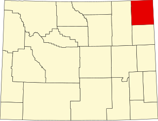
This is intended to be a complete list of the properties and districts on the National Register of Historic Places in Big Horn County, Wyoming, United States. The locations of National Register properties and districts for which the latitude and longitude coordinates are included below, may be seen in a map.[1]
There are 23 properties and districts listed on the National Register in the county, 1 of which is a National Historic Landmark.
Meeting hall significant as a key gathering place in Greybull 1935–1959 for a panoply of social clubs and organizations, as well as civic use as a polling place and overflow classroom for the public schools.[5]
Remnants of a cairn-marked trail between the Bighorn Basin and the northern plains, established by Native Americans in antiquity and used by their descendents and mountain men into the mid-1830s. Extends into Carbon County, Montana.[6]
Newspaper office with vintage equipment, active 1924–1974 printing the continuation of the Bighorn Basin's first newspaper, established in 1889 by Joseph Newton DeBarthe—a key record of local history.[7]
The Bighorn Basin's first high school and a long-serving community venue, with a 1916 classroom building initially constructed as a Mormon parochial boarding school, and a 1936 gymnasium funded by the Works Progress Administration.[9]
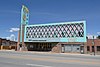
Prominent and architecturally sophisticated 1916 commercial building with a 1933 car dealership and repair shop addition, encapsulating Greybull's oil boom prosperity and later diversification through auto tourism.[13]
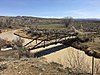
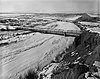
1917 camelback pony truss bridge, Wyoming's longest, and its only road bridge jointly funded by two counties, on the mistaken belief that it crossed a county boundary.[14]
Paleo-Indian camping ground on either side of an arroyo, with extensive evidence of stone tool manufacturing, fires, animal bone fragments, and Folsom tradition lodges.[15]
1903 one-room school, one of Wyoming's few intact examples of the once-essential facilities built to provide education and community meeting space in frontier communities.[17]
Four surviving buildings of an 1883 ranch, associated with Henry Clay Lovell (1838–1903) and the development of open range cattle ranching in the Bighorn Basin in 1880s and 1890s. Now an interpretive site.[18]
Sheltered wintering site with rock art and 12 habitation layers spanning from 8300 years ago to the early contact period.[19] Preserved and interpreted as Medicine Lodge State Archeological Site.
Significant and well-preserved Native American sacred complex in use for at least 7000 years, comprising a 75-foot-diameter (23m) medicine wheel, archaeological sites, and traditional use areas.[21]
The longest single-span truss bridge ever built by a Wyoming county, and one of the state's only two remaining pin-connected Pennsylvania trusses. Erected in 1916 and abandoned in place in 1979.[14]
Municipal event venue built 1933–34 with Civil Works Administration funding, exemplifying the enduring benefit of New Deal programs for small Wyoming communities.[23]
Rock shelter with five well-stratified occupation layers spanning the early Paleo-Indian to late Prehistoric periods, illuminating the area's chronology of projectile points and early subsistence strategies.[24]
1939 post office, one of five in Wyoming with Section of Painting and Sculpture artwork, symbolizing the extensive New Deal public works and federal presence benefiting small communities.[26]
This is a list of the National Register of Historic Places listings in Dakota County, Minnesota. It is intended to be a complete list of the properties and districts on the National Register of Historic Places in Dakota County, Minnesota, United States. Dakota County is located in the southeastern part of the U.S. state of Minnesota, bounded on the northeast side by the Upper Mississippi River and on the northwest by the Minnesota River. The locations of National Register properties and districts for which the latitude and longitude coordinates are included below, may be seen in an online map.
This is a list of the National Register of Historic Places listings in Scott County, Minnesota. It is intended to be a complete list of the properties and districts on the National Register of Historic Places in Scott County, Minnesota, United States. The locations of National Register properties and districts for which the latitude and longitude coordinates are included below, may be seen in an online map.
This is a list of the National Register of Historic Places listings in Morrison County, Minnesota. It is intended to be a complete list of the properties and districts on the National Register of Historic Places in Morrison County, Minnesota, United States. The locations of National Register properties and districts for which the latitude and longitude coordinates are included below, may be seen in an online map.
This is a list of the National Register of Historic Places listings in Otter Tail County, Minnesota. It is intended to be a complete list of the properties and districts on the National Register of Historic Places in Otter Tail County, Minnesota, United States. The locations of National Register properties and districts for which the latitude and longitude coordinates are included below, may be seen in an online map.
This is a list of the National Register of Historic Places listings in Winona County, Minnesota. It is intended to be a complete list of the properties and districts on the National Register of Historic Places in Winona County, Minnesota, United States. The locations of National Register properties and districts for which the latitude and longitude coordinates are included below, may be seen in an online map.
This is a list of the National Register of Historic Places listings in Le Sueur County, Minnesota. It is intended to be a complete list of the properties and districts on the National Register of Historic Places in Le Sueur County, Minnesota, United States. The locations of National Register properties and districts for which the latitude and longitude coordinates are included below, may be seen in an online map.
This is a list of the National Register of Historic Places listings in Lake County, Minnesota. It is intended to be a complete list of the properties and districts on the National Register of Historic Places in Lake County, Minnesota, United States. The locations of National Register properties and districts for which the latitude and longitude coordinates are included below, may be seen in an online map.
This is a list of the National Register of Historic Places listings in Cook County, Minnesota. It is intended to be a complete list of the properties and districts on the National Register of Historic Places in Cook County, Minnesota, United States. The locations of National Register properties and districts for which the latitude and longitude coordinates are included below, may be seen in an online map.
This is a list of the National Register of Historic Places listings in Douglas County, Minnesota. It is intended to be a complete list of the properties and districts on the National Register of Historic Places in Douglas County, Minnesota, United States. The locations of National Register properties and districts for which the latitude and longitude coordinates are included below, may be seen in an online map.
This is a list of the National Register of Historic Places listings in Houston County, Minnesota. It is intended to be a complete list of the properties and districts on the National Register of Historic Places in Houston County, Minnesota, United States. The locations of National Register properties and districts for which the latitude and longitude coordinates are included below, may be seen in an online map.
This is a list of the National Register of Historic Places listings in Crook County, Wyoming.
This is a list of the National Register of Historic Places listings in Johnson County, Wyoming. It is intended to be a complete list of the properties and districts on the National Register of Historic Places in Johnson County, Wyoming, United States. The locations of National Register properties and districts for which the latitude and longitude coordinates are included below, may be seen in an online map.
This is a list of the National Register of Historic Places listings in Park County, Wyoming.
This is a list of the National Register of Historic Places listings in Uinta County, Wyoming.
This is a list of the National Register of Historic Places listings in Washakie County, Wyoming. It is intended to be a complete list of the properties and districts on the National Register of Historic Places in Washakie County, Wyoming, United States. The locations of National Register properties and districts for which the latitude and longitude coordinates are included below, may be seen in a map.
This is a list of the National Register of Historic Places listings in Weston County, Wyoming. It is intended to be a complete list of the properties and districts on the National Register of Historic Places in Weston County, Wyoming, United States. The locations of National Register properties and districts for which the latitude and longitude coordinates are included below, may be seen in a map.
This is a list of the National Register of Historic Places listings in Lyon County, Minnesota. It is intended to be a complete list of the properties and districts on the National Register of Historic Places in Lyon County, Minnesota, United States. The locations of National Register properties and districts for which the latitude and longitude coordinates are included below, may be seen in an online map.
This is a list of the National Register of Historic Places listings in Yellowstone National Park.
This is a list of the National Register of Historic Places listings in Martin County, Minnesota. It is intended to be a complete list of the properties and districts on the National Register of Historic Places in Martin County, Minnesota, United States. The locations of National Register properties and districts for which the latitude and longitude coordinates are included below, may be seen in an online map.
References
↑ The latitude and longitude information provided in this table was derived originally from the National Register Information System, which has been found to be fairly accurate for about 99% of listings. Some locations in this table may have been corrected to current GPS standards.
↑ Numbers represent an alphabetical ordering by significant words. Various colorings, defined here, differentiate National Historic Landmarks and historic districts from other NRHP buildings, structures, sites or objects.
↑ The eight-digit number below each date is the number assigned to each location in the National Register Information System database, which can be viewed by clicking the number.
This page is based on this Wikipedia article Text is available under the CC BY-SA 4.0 license; additional terms may apply. Images, videos and audio are available under their respective licenses.