National Register of Historic Places listings in Johnson County, Wyoming
Last updated
National Register of Historic Places listings in Johnson
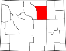
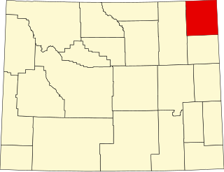
Location of Johnson County in Wyoming
This is a list of the National Register of Historic Places listings in Johnson County, Wyoming. It is intended to be a complete list of the properties and districts on the National Register of Historic Places in Johnson County, Wyoming, United States. The locations of National Register properties and districts for which the latitude and longitude coordinates are included below, may be seen in an online map.[1]
A rare and well-preserved example of a 20th-century sheep ranch employing Spanish and French Basque practices, with nine contributing properties built 1916–1950s.[6]
Western-themed motor court with free-standing log cabins, whose modernizations 1941–1967 reflect the heyday of post-World War II automobile tourism in Wyoming.[7]
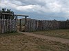
Site of an Army supply post 1876–1878 during U.S. military campaigns against the High Plains Indians, a vestige of the bitter intercultural conflict over the resources and lifestyle of the region.[8]
1909 Carnegie library, exemplifying Neoclassical architecture and the local zeal to provide library services while still less than a decade into Wyoming's statehood.[9] Became the Jim Gatchell Memorial Museum in 1987.[10]
Site of the Dull Knife Fight on November 25, 1876—an Army attack on a winter village of Northern Cheyenne, a consequential point in the U.S. campaign to force the Plains Indians onto reservations.[11]
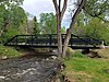
At 200 feet (61m) Wyoming's longest single span of a county bridge still in use, and one of only two pin-connected Pennsylvania trusses. Built in 1913 and moved to current location in 1963.[5]
Frontier U.S. Army fort with some preserved buildings, active 1878–1894; the key military presence in the Powder River Basin from the American Indian Wars to the Johnson County War, and attractor of agricultural settlement as both a protector and customer. Since 1903 the Veterans' Home of Wyoming.[12]
Sites of a partially reconstructed U.S. Army fort, the Fetterman Fight, and the Wagon Box Fight—storied locations in Red Cloud's War 1866–1868, which resulted in renewed Native control of the region for several years.[13]
Site of a U.S. Army fort manned 1865–1868 to protect emigrants on the Bozeman Trail from vigorous Oglala defense of their sacred hunting grounds. Marked with a monument and interpretive signs.[14]
1890s cattle ranch diversified into a dude ranch in 1911, a continuously operating example of an important regional enterprise that enriched the American West economically and culturally, and highlighted the need to preserve the west's recreational resources and traditions.[15]
One of Buffalo's first brick houses, built in 1883 for rancher and county official William H. Holland (1840–1906) and later the home of his grandson William C. Holland (d. 1993), attorney and politician.[16]
Site in a natural passage between the Bighorn Mountains and Powder River basin yielding artifacts from the middle Plains Archaic to the Protohistoric period, including a hearth, bundle of gambling sticks, and rock art.[18]
One of Wyoming's most distinctive and intact commercial centers representing the prosperity achieved through ranching, agriculture, tourism, and mineral extraction; with 12 contributing properties built 1900–1932.[21]
One of Wyoming's leading examples of Gothic Revival architecture, an 1889 church whose original members were key figures in Buffalo's and Johnson County's early history.[24]
One of the longest operating dude ranches in the Bighorn Mountains, established in 1923. Also noted for its rustic architecture, with a unique lodge shaped like the ranch's brand and eight other contributing properties.[25]
Long-serving social and civic center of a dispersed ranching community, built in 1914 as a post office, grocery store, and dance hall, and entirely an event venue and polling place since the 1920s.[26]
One of Johnson County's first cattle ranches, established in 1882, and the best preserved site from the 1889–1893 Johnson County War, with extant breastworks and battle damage from a three-day siege in April 1892.[27]
Ford and campsite on the Bozeman Trail, site of one of the trail's most dramatic battles between the U.S. military and Native Americans, on July 20, 1866, and a U.S. staging point during the Great Sioux War of 1876.[28] Marked with interpretive signs.
1886 church altered and enlarged 1911–12, with a 1910 parsonage. One of the first two churches established in northern Wyoming Territory; significant as the only venue for refined or family-friendly activities in a rough pioneer community.[29]
Well-preserved example of a Neoclassical combined post office and federal building, completed in 1928; a long-sought amenity and validation of Buffalo's importance.[30]
This list is intended to be a complete compilation of properties and districts listed on the National Register of Historic Places in Rensselaer County, New York, United States. Seven of the properties are further designated National Historic Landmarks.
This is a list of the National Register of Historic Places listings in Dakota County, Minnesota. It is intended to be a complete list of the properties and districts on the National Register of Historic Places in Dakota County, Minnesota, United States. Dakota County is located in the southeastern part of the U.S. state of Minnesota, bounded on the northeast side by the Upper Mississippi River and on the northwest by the Minnesota River. The locations of National Register properties and districts for which the latitude and longitude coordinates are included below, may be seen in an online map.
This list is of the properties and historic districts which are designated on the National Register of Historic Places or that were formerly so designated, in Hennepin County, Minnesota; there are 190 entries as of April 2023. A significant number of these properties are a result of the establishment of Fort Snelling, the development of water power at Saint Anthony Falls, and the thriving city of Minneapolis that developed around the falls. Many historic sites outside the Minneapolis city limits are associated with pioneers who established missions, farms, and schools in areas that are now suburbs in that metropolitan area.
The Jim Gatchell Memorial Museum is an American West museum in Buffalo, Wyoming, housed in a 1909 Carnegie Library building.
This is a list of the National Register of Historic Places listings in Saint Louis County, Minnesota. It is intended to be a complete list of the properties and districts on the National Register of Historic Places in Saint Louis County, Minnesota, United States. The locations of National Register properties and districts for which the latitude and longitude coordinates are included below, may be seen in an online map.
This is a list of the National Register of Historic Places listings in Nicollet County, Minnesota. It is intended to be a complete list of the properties and districts on the National Register of Historic Places in Nicollet County, Minnesota, United States. The locations of National Register properties and districts for which the latitude and longitude coordinates are included below, may be seen in an online map.
This is a list of the National Register of Historic Places listings in Otter Tail County, Minnesota. It is intended to be a complete list of the properties and districts on the National Register of Historic Places in Otter Tail County, Minnesota, United States. The locations of National Register properties and districts for which the latitude and longitude coordinates are included below, may be seen in an online map.
The Grace and Robert Miller Ranch represents an expansion of the previously existing Miller Cabin listing on the National Register of Historic Places. The ranch was the home of Robert E. Miller, first superintendent of Jackson Hole National Monument. The property was transferred to the U.S. Fish and Wildlife Service as part of the National Elk Refuge.
This is a list of the National Register of Historic Places listings in Winona County, Minnesota. It is intended to be a complete list of the properties and districts on the National Register of Historic Places in Winona County, Minnesota, United States. The locations of National Register properties and districts for which the latitude and longitude coordinates are included below, may be seen in an online map.
This is a list of the National Register of Historic Places listings in Le Sueur County, Minnesota. It is intended to be a complete list of the properties and districts on the National Register of Historic Places in Le Sueur County, Minnesota, United States. The locations of National Register properties and districts for which the latitude and longitude coordinates are included below, may be seen in an online map.
This is a list of the National Register of Historic Places listings in Lake County, Minnesota. It is intended to be a complete list of the properties and districts on the National Register of Historic Places in Lake County, Minnesota, United States. The locations of National Register properties and districts for which the latitude and longitude coordinates are included below, may be seen in an online map.
This is a list of the National Register of Historic Places listings in Cass County, Minnesota. It is intended to be a complete list of the properties and districts on the National Register of Historic Places in Cass County, Minnesota, United States. The locations of National Register properties and districts for which the latitude and longitude coordinates are included below, may be seen in an online map.
This is a list of the National Register of Historic Places listings in Big Horn County, Wyoming.
This is a list of the National Register of Historic Places listings in Crook County, Wyoming.
This is a list of the National Register of Historic Places listings in Park County, Wyoming.
This is a list of the National Register of Historic Places listings in Washakie County, Wyoming. It is intended to be a complete list of the properties and districts on the National Register of Historic Places in Washakie County, Wyoming, United States. The locations of National Register properties and districts for which the latitude and longitude coordinates are included below, may be seen in a map.
This is a list of the National Register of Historic Places listings in Campbell County, Wyoming. It is intended to be a complete list of the properties and districts on the National Register of Historic Places in Campbell County, Wyoming, United States. The locations of National Register properties and districts for which the latitude and longitude coordinates are included below, may be seen in a map.
This is a list of the National Register of Historic Places listings in Yellowstone National Park.
The historical buildings and structures of Grand Teton National Park include a variety of buildings and built remains that pre-date the establishment of Grand Teton National Park, together with facilities built by the National Park Service to serve park visitors. Many of these places and structures have been placed on the National Register of Historic Places. The pre-Park Service structures include homestead cabins from the earliest settlement of Jackson Hole, working ranches that once covered the valley floor, and dude ranches or guest ranches that catered to the tourist trade that grew up in the 1920s and 1930s, before the park was expanded to encompass nearly all of Jackson Hole. Many of these were incorporated into the park to serve as Park Service personnel housing, or were razed to restore the landscape to a natural appearance. Others continued to function as inholdings under a life estate in which their former owners could continue to use and occupy the property until their death. Other buildings, built in the mountains after the initial establishment of the park in 1929, or in the valley after the park was expanded in 1950, were built by the Park Service to serve park visitors, frequently employing the National Park Service Rustic style of design.
This is a list of the National Register of Historic Places listings in Martin County, Minnesota. It is intended to be a complete list of the properties and districts on the National Register of Historic Places in Martin County, Minnesota, United States. The locations of National Register properties and districts for which the latitude and longitude coordinates are included below, may be seen in an online map.
References
↑ The latitude and longitude information provided in this table was derived originally from the National Register Information System, which has been found to be fairly accurate for about 99% of listings. Some locations in this table may have been corrected to current GPS standards.
↑ Numbers represent an alphabetical ordering by significant words. Various colorings, defined here, differentiate National Historic Landmarks and historic districts from other NRHP buildings, structures, sites or objects.
↑ The eight-digit number below each date is the number assigned to each location in the National Register Information System database, which can be viewed by clicking the number.
This page is based on this Wikipedia article Text is available under the CC BY-SA 4.0 license; additional terms may apply. Images, videos and audio are available under their respective licenses.