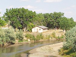
Kaycee is a town in Johnson County, Wyoming, United States. The population was 247 at the 2020 census. It is home to a museum that preserves the cattle ranching heritage of the area, especially the history of the Johnson County War.

Big Horn is an unincorporated community and census-designated place (CDP) in Sheridan County, Wyoming, United States. The population was 457 at the 2020 census.

Fort Laramie was a significant 19th-century trading post, diplomatic site, and military installation located at the confluence of the Laramie and the North Platte Rivers. They joined in the upper Platte River Valley in the eastern part of the present-day U.S. state of Wyoming. The fort was founded as a private trading-post in the 1830s to service the overland fur trade; in 1849, it was purchased by the United States Army. The site was located east of the long climb leading to the best and lowest crossing-point over the Rocky Mountains at South Pass and became a popular stopping-point for migrants on the Oregon Trail. Along with Bent's Fort on the Arkansas River, the trading post and its supporting industries and businesses were the most significant economic hub of commerce in the region.

The Bozeman Trail was an overland route in the Western United States, connecting the gold rush territory of southern Montana to the Oregon Trail in eastern Wyoming. Its most important period was from 1863 to 1868. Despite the fact that the major part of the route in Wyoming used by all Bozeman Trail travelers in 1864 was pioneered by Allen Hurlbut, it was named after John Bozeman. Many miles of the Bozeman Trail in present Montana followed the tracks of Bridger Trail, opened by Jim Bridger in 1864.
The Dull Knife Fight, or the Battle on the Red Fork, part of the Great Sioux War of 1876, was fought on November 25, 1876, in present-day Johnson County, Wyoming between soldiers and scouts of the United States Army and warriors of the Northern Cheyenne. The battle essentially ended the Northern Cheyennes' ability to continue the fight for their freedom on the Great Plains.

Fort Phil Kearny was an outpost of the United States Army that existed in the late 1860s in present-day northeastern Wyoming along the Bozeman Trail. Construction began in 1866 on Friday, July 13, by Companies A, C, E, and H of the 2nd Battalion, 18th Infantry, under the direction of the regimental commander and Mountain District commander Colonel Henry B. Carrington.

Fort Fetterman was constructed in 1867 by the United States Army on the Great Plains frontier in Dakota Territory, approximately 11 miles northwest of present-day Douglas, Wyoming. Located high on the bluffs south of the North Platte River, it served as a major base for the start of several United States military expeditions against warring Native American tribes. The fort is listed on the National Register of Historic Places.

Fort Reno also known as Fort Connor or Old Fort Reno, was a wooden fort established on August 15, 1865 by the United States Army in Dakota Territory in present-day Johnson County, Wyoming. The fort was built to protect travelers on the Bozeman Trail from Native American tribes.

Fort C. F. Smith was a military post established in the Powder River country by the United States Army in Montana Territory on August 12, 1866, during Red Cloud's War. Established by order of Col. Henry B. Carrington, it was one of five forts proposed to protect the Bozeman Trail against the Oglala Lakota (Sioux), who saw the trail as a violation of the 1851 Treaty of Fort Laramie. The fort was abandoned in 1868 and burned by the Sioux under Red Cloud.

Interstate 25 (I-25) is a part of the Interstate Highway System that runs from Las Cruces, New Mexico, to Buffalo, Wyoming. In Wyoming, the Interstate Highway runs 300.530 miles (483.656 km) from the Colorado state line near Cheyenne north to its national terminus at I-90 near Buffalo. I-25 connects Wyoming's largest city and capital, Cheyenne, with its second largest city, Casper, and the smaller communities of Wheatland, Douglas, and Buffalo. The highway also connects those cities with Denver and Billings via I-90. I-25 runs concurrently with U.S. Route 87 (US 87) for almost its entire course in Wyoming. The highway also has extensive concurrencies with US 20 and US 26 along its east–west segment through the North Platte River valley. The Interstate has business loops through Cheyenne, Chugwater, Wheatland, Douglas, Glenrock, Casper, and Buffalo.

The Bridger Trail, also known as the Bridger Road and Bridger Immigrant Road, was an overland route connecting the Oregon Trail to the gold fields of Montana. Gold was discovered in Virginia City, Montana in 1863, prompting settlers and prospectors to find a trail to travel from central Wyoming to Montana. In 1863, John Bozeman and John Jacobs scouted the Bozeman Trail, which was a direct route to the Montana gold fields through the Powder River Country. At the time the region was controlled by the Sioux, Cheyenne and Arapaho, who stepped up their raids in response to the stream of settlers along the trail.

There is evidence of prehistoric human habitation in the region known today as the U.S. state of Wyoming stretching back roughly 13,000 years. Stone projectile points associated with the Clovis, Folsom and Plano cultures have been discovered throughout Wyoming. Evidence from what is now Yellowstone National Park indicates the presence of vast continental trading networks since around 1,000 years ago.

The Emigrant Trail in Wyoming, which is the path followed by Western pioneers using the Oregon, California, and Mormon Trails, spans 400 miles (640 km) through the U.S. state of Wyoming. The trail entered from Nebraska on the eastern border of the state near the present day town of Torrington and exited on the western border near the towns of Cokeville and Afton. An estimated 350,000 to 400,000 settlers traveled on the trail through Wyoming between 1841 and 1868. All three trails follow the same path through most of the state. The Mormon Trail splits at Fort Bridger and enters Utah, while the Oregon and California Trails continue to Idaho.

This is a list of the National Register of Historic Places listings in Johnson County, Wyoming. It is intended to be a complete list of the properties and districts on the National Register of Historic Places in Johnson County, Wyoming, United States. The locations of National Register properties and districts for which the latitude and longitude coordinates are included below, may be seen in an online map.

Fort McKinney (1877–1894) was a military post located in North Eastern Wyoming, near the Powder River.

Cantonment Reno also known as Fort McKinney 1 was a US Army post or cantonment located on the Powder River near the old Bozeman Trail crossing. A previous fort near the site had been abandoned and burned after the Fort Laramie Treaty of 1868. Cantonment Reno was re-established in late 1876, just upstream of the site of old Fort Reno. Cantonment Reno started as a temporary base of operations for General George Crooks' 1876 Big Horn Expedition,. Crook's Expedition was part of the intensive campaign against the Sioux and Cheyenne in late 1876, following Custer's defeat at the Battle of the Little Bighorn.

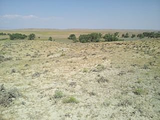
The Powder River Crossing, officially known as Powder River Station-Powder River Crossing , is an abandoned settlement located on the east bank of the Powder River in southeast Johnson County about twenty-four miles east of Kaycee, Wyoming. It developed after a wooden toll bridge was built across the Powder River in 1877, at a site that was originally used as a ford. With crossing secured, a settlement developed here in the late 19th century, incorporating a stage stop on the Bozeman Trail. The site is notable for having well-preserved wagon ruts from the pioneer era.
Crazy Woman Crossing is a historic place on the Bozeman Trail, in Johnson County, Wyoming, United States, about twenty miles southeast of Buffalo. Crazy Woman Crossing was one of three major fords used by travelers across creeks and rivers in this area. It is significant as the site of the Battle of Crazy Woman, a skirmish during Red Cloud's War in 1866. The United States pulled out of this territory after negotiation with the Lakota and allies of the Treaty of Fort Laramie of 1868.
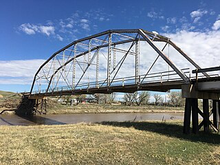
The EDZ Irigary Bridge is a historic Pennsylvania truss bridge in southeastern Johnson County, Wyoming. The bridge was built in 1913 at Sussex, Wyoming, and moved in 1963 to Irigary Road. The bridge was listed on the National Register of Historic Places in 1985 as part of a Multiple Property Submission devoted to historic bridges in Wyoming.
The Townsend Wagon Train Fight occurred on the Bozeman Trail near the Powder River and present day Kaycee, Wyoming on July 7, 1864. This wagon train consisted mainly of emigrants from Wisconsin, Illinois and Iowa who were heading to the gold rush area of Virginia City, Montana. The emigrants were attacked by Native Americans who were upset that they were entering their hunting lands. Led by Captain Absalom Austin Townsend the wagon train was one of the largest ever assembled with over 400 people and 150+ wagons. The Bozeman Trail was started by John Bozeman in 1863 as a short cut from the Oregon Trail to the gold fields of SW Montana. Bozeman led the first wagon train of the year in 1864 and the Townsend Wagon Train was the third such train down the trail.