The Cheyenne are an Indigenous people of the Great Plains. Their Cheyenne language belongs to the Algonquian language family. Today, the Cheyenne people are split into two federally recognized nations: the Southern Cheyenne, who are enrolled in the Cheyenne and Arapaho Tribes in Oklahoma, and the Northern Cheyenne, who are enrolled in the Northern Cheyenne Tribe of the Northern Cheyenne Indian Reservation in Montana. The Cheyenne comprise two Native American tribes, the Só'taeo'o or Só'taétaneo'o and the Tsétsêhéstâhese. The tribes merged in the early 19th century.

Little Bighorn Battlefield National Monument preserves the site of the June 25 and 26, 1876, Battle of the Little Bighorn, near Crow Agency, Montana, in the United States. It also serves as a memorial to those who fought in the battle: George Armstrong Custer's 7th Cavalry and a combined Lakota-Northern Cheyenne and Arapaho force. Custer National Cemetery, on the battlefield, is part of the national monument. The site of a related military action led by Marcus Reno and Frederick Benteen is also part of the national monument, but is about 3 miles (4.83 km) southeast of the Little Bighorn battlefield.

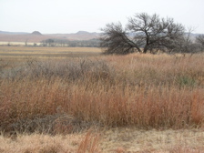
The Battle of the Rosebud took place on June 17, 1876, in the Montana Territory between the United States Army and its Crow and Shoshoni allies against a force consisting mostly of Lakota Sioux and Northern Cheyenne Indians during the Great Sioux War of 1876. The Cheyenne called it the Battle Where the Girl Saved Her Brother because of an incident during the fight involving Buffalo Calf Road Woman. General George Crook's offensive was stymied by the Indians, led by Crazy Horse, and he awaited reinforcements before resuming the campaign in August.
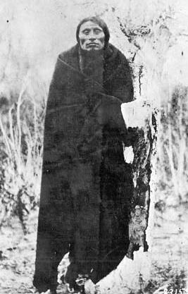
Little Wolf was a Northern Só'taeo'o Chief and Sweet Medicine Chief of the Northern Cheyenne. He was known as a great military tactician and led a dramatic escape from confinement in Oklahoma back to the Northern Cheyenne homeland in 1878, known as the Northern Cheyenne Exodus.
The Battle of the Tongue River, sometimes referred to as the Connor Battle, was an engagement of the Powder River Expedition that occurred on August 29, 1865. In the battle, U.S. soldiers and Indian scouts attacked and destroyed an Arapaho village.
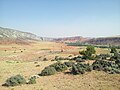
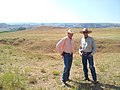
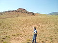
The Dull Knife Fight, or the Battle on the Red Fork, part of the Great Sioux War of 1876, was a battle that was fought on November 25, 1876, in present-day Johnson County, Wyoming between soldiers and scouts of the United States Army and warriors of the Northern Cheyenne. The battle essentially ended the Northern Cheyennes' ability to continue the fight for their freedom on the Great Plains.
Washita Battlefield National Historic Site protects and interprets the site of the Southern Cheyenne village of Chief Black Kettle where the Battle of Washita occurred. The site is located about 150 miles (241 km) west of Oklahoma City, Oklahoma, near Cheyenne, Oklahoma. Just before dawn on November 27, 1868, the village was attacked by the 7th U.S. Cavalry under Lt. Col. George Custer. In the Battle of Washita, the Cheyenne suffered large numbers of casualties. The strike was hailed at the time by the military and many civilians as a significant victory aimed at reducing Indian raids on frontier settlements as it forced the Cheyenne back to the reservation set aside for them. The site is a small portion of a large area that was declared a National Historic Landmark in 1965, and was listed on the National Register of Historic Places in 1966. The landmarked area encompasses the entire battlefield, which extends for some 6 miles (9.7 km) through the city of Cheyenne.

The Battle of Wolf Mountain was a battle fought on January 8, 1877, by soldiers of the United States Army against Lakota Sioux and Northern Cheyenne warriors during the Great Sioux War of 1876. The battle was fought in southern Montana Territory, about four miles southwest of modern-day Birney, Montana, along the Tongue River.

The Battle of Powder River, also known as the Reynolds Battle, occurred on March 17, 1876, in Montana Territory, United States. The attack on a Cheyenne Indian encampment by Colonel Joseph J. Reynolds initiated the Great Sioux War of 1876. Although destroying a large amount of Indian property, the attack was poorly carried out and probably solidified Lakota Sioux and northern Cheyenne resistance to the U.S. attempt to force them to sell the Black Hills and live on a reservation.

Fort Fetterman was constructed in 1867 by the United States Army on the Great Plains frontier in Dakota Territory, approximately 11 miles northwest of present-day Douglas, Wyoming. Located high on the bluffs south of the North Platte River, it served as a major base for the start of several United States military expeditions against warring Native American tribes. The fort is listed on the National Register of Historic Places.
Wolf Mountains Battlefield/Where Big Crow Walked Back and Forth was the site of the Battle of Wolf Mountain, the last major combat of the Great Sioux War of 1876–77. It was added to the National Register of Historic Places in 2001, and was designated a National Historic Landmark in 2008.

The Great Sioux War of 1876, also known as the Black Hills War, was a series of battles and negotiations that occurred in 1876 and 1877 in an alliance of Lakota Sioux and Northern Cheyenne against the United States. The cause of the war was the desire of the US government to obtain ownership of the Black Hills. Gold had been discovered in the Black Hills, settlers began to encroach onto Native American lands, and the Sioux and the Cheyenne refused to cede ownership. Traditionally, American military and historians place the Lakota at the center of the story, especially because of their numbers, but some Native Americans believe the Cheyenne were the primary target of the American campaign.

This is a list of the National Register of Historic Places listings in Johnson County, Wyoming. It is intended to be a complete list of the properties and districts on the National Register of Historic Places in Johnson County, Wyoming, United States. The locations of National Register properties and districts for which the latitude and longitude coordinates are included below, may be seen in an online map.
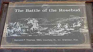
Rosebud Battlefield State Park in Big Horn County, Montana preserves a large portion of the battlefield of the Battle of the Rosebud, fought on June 17, 1876. The battle is known by various other names such as The Battle Where the Girl Saved Her Brother by the Northern Cheyenne, and Crook's Fight on the Rosebud. A National Historic Landmark, the park is a day use facility offering hiking, hunting, picnicking and wildlife viewing. It is located 11 miles (18 km) south of Kirby, Montana on Montana Highway 314.
The Bates Battlefield was the scene of an 1874 action in which an Arapaho encampment was attacked by U.S. Army forces under Captain Alfred E. Bates. The battlefield is a narrow valley in Hot Springs County, Wyoming near the junction of the Big Horn Mountains and the Owl Creek Mountains. Variously called the Bates Battle, the Battle of Young's Point, the Battle of Snake Mountain and the Nowood Battle, the action was part of a campaign by forces under the command of Lieutenant General Philip Sheridan to protect the comparatively sedentary Shoshone under Chief Washakie from raids by their traditional enemies, the Northern Cheyenne, the Sioux and the Northern Arapaho.

The Northern Cheyenne Exodus, also known as Dull Knife's Raid, the Cheyenne War, or the Cheyenne Campaign, was the attempt of the Northern Cheyenne to return to the north, after being placed on the Southern Cheyenne reservation in the Indian Territory, and the United States Army operations to stop them. The period lasted from 1878 to 1879.
First Sergeant Thomas Hall Forsyth was an American soldier in the U.S. Army who served with the 4th U.S. Cavalry during the Indian Wars. He received the Medal of Honor for gallantry against the Cheyenne Indians, rescuing his commanding officer and another wounded soldier, at the Powder River in Wyoming Territory on November 25, 1876. Although two fellow soldiers assisted in helping him protect their fallen commander, he is the only member of the Powder River Expedition to receive an award.

Fort McKinney (1877–1894) was a military post located in North Eastern Wyoming, near the Powder River.

Cantonment Reno also known as Fort McKinney 1 was a US Army post or cantonment located on the Powder River near the old Bozeman Trail crossing. A previous fort near the site had been abandoned and burned after the Fort Laramie Treaty of 1868. Cantonment Reno was re-established in late 1876, just upstream of the site of old Fort Reno. Cantonment Reno started as a temporary base of operations for General George Crooks' 1876 Big Horn Expedition,. Crook's Expedition was part of the intensive campaign against the Sioux and Cheyenne in late 1876, following Custer's defeat at the Battle of the Little Bighorn.
Fort Mackenzie is a former U.S. Army post in Sheridan, Wyoming, now used by the U.S. Veterans Administration as the Sheridan Veterans Administration Medical Center.