National Register of Historic Places listings in Teton County, Wyoming

Last updated

Location of Teton County in Wyoming Map of Wyoming highlighting Teton County.svg
Location of Teton County in Wyoming

This is a list of the National Register of Historic Places listings in Teton County, Wyoming.

Contents

This is intended to be a complete list of the properties and districts on the National Register of Historic Places in Teton County, Wyoming, United States.

There are 62 properties and districts listed on the National Register in the county, 5 of which are National Historic Landmarks. Another property was once listed on the Register but has been removed.


    This National Park Service list is complete through NPS recent listings posted July 7, 2023. [1]

Map all coordinates using: OpenStreetMap  
Contents: Counties in Wyoming
Albany - Big Horn - Campbell - Carbon - Converse - Crook - Fremont - Goshen - Hot Springs - Johnson - Laramie - Lincoln - Natrona - Niobrara - Park - Platte - Sheridan - Sublette - Sweetwater - Teton - Uinta - Washakie - Weston

Current listings

[2] Name on the RegisterImageDate listed [3] Location City or townDescription
1 4 Lazy F Dude Ranch
4 Lazy F Dude Ranch 4 Lazy F Dude Ranch Lodge.jpg
4 Lazy F Dude Ranch
April 23, 1990
(#90000611)
Off Teton Park Rd.
43°40′03″N110°42′27″W / 43.6675°N 110.7075°W / 43.6675; -110.7075 (4 Lazy F Dude Ranch)
Moose
2 AMK Ranch
AMK Ranch AMK Berol Lodge.jpg
AMK Ranch
April 23, 1990
(#90000615)
Off U.S. Routes 27/89
43°56′20″N110°38′30″W / 43.9389°N 110.6417°W / 43.9389; -110.6417 (AMK Ranch)
Moran
3 Alpenhof Lodge
Alpenhof Lodge TetonVillageWY TheAlpenhof.jpg
Alpenhof Lodge
August 9, 2016
(#16000520)
3255 W. Village Dr.
43°35′16″N110°49′34″W / 43.5879°N 110.8261°W / 43.5879; -110.8261 (Alpenhof Lodge)
Teton Village
4 Bar B C Dude Ranch
Bar B C Dude Ranch Bar B C Ranch Main Cabin.jpg
Bar B C Dude Ranch
April 23, 1990
(#90000624)
Off Teton Park Rd.
43°41′42″N110°41′42″W / 43.695°N 110.695°W / 43.695; -110.695 (Bar B C Dude Ranch)
Moose
5 Bridge over Snake River-Structure DEY
Bridge over Snake River-Structure DEY Bridge Over Snake River2 NRHP 100007949 Teton County, WY.jpg
Bridge over Snake River-Structure DEY
August 1, 2022
(#100007949)
County Road 11, 7.5 mi. south of Jackson
43°22′18″N110°44′21″W / 43.371797°N 110.739138°W / 43.371797; -110.739138 (Bridge over Snake River-Structure DEY)
Jackson
6 The Brinkerhoff
The Brinkerhoff The Brinkerhoff.jpg
The Brinkerhoff
April 23, 1990
(#90000622)
Teton Park Rd.
43°51′03″N110°35′35″W / 43.8508°N 110.5931°W / 43.8508; -110.5931 (The Brinkerhoff)
Moose
7 Cascade Canyon Barn
Cascade Canyon Barn Cascade Canyon Barn.jpg
Cascade Canyon Barn
August 18, 1998
(#98001023)
Cascade Canyon 5 miles upstream from Jenny Lake
43°46′05″N110°49′22″W / 43.7681°N 110.8228°W / 43.7681; -110.8228 (Cascade Canyon Barn)
Moose
8 Andy Chambers Ranch Historic District
Andy Chambers Ranch Historic District Andy Chambers Ranch Barn.jpg
Andy Chambers Ranch Historic District
April 23, 1990
(#90000623)
Mormon Row east of Moose
43°39′29″N110°39′41″W / 43.6581°N 110.6614°W / 43.6581; -110.6614 (Andy Chambers Ranch Historic District)
Moose
9 Chapel of the Transfiguration
Chapel of the Transfiguration Chapel of the Transfiguration Grand Teton NP1.jpg
Chapel of the Transfiguration
April 10, 1980
(#80004055)
Grand Teton National Park
43°39′37″N110°42′52″W / 43.6603°N 110.7144°W / 43.6603; -110.7144 (Chapel of the Transfiguration)
Moose
10 Cunningham Cabin
Cunningham Cabin Cunningham Cabin in Jackson Hole.JPG
Cunningham Cabin
October 2, 1973
(#73000225)
Northeast of Moose off U.S. Routes 26/89/187 in Grand Teton National Park
43°46′44″N110°33′28″W / 43.7789°N 110.5578°W / 43.7789; -110.5578 (Cunningham Cabin)
Moose
11 Darwin Ranch April 27, 2021
(#100005445)
1 Kinky Creek Rd.
43°24′44″N110°09′41″W / 43.4123°N 110.1613°W / 43.4123; -110.1613 (Darwin Ranch)
Cora vicinity
12 Death Canyon Barn
Death Canyon Barn Death Canyon Barn.jpg
Death Canyon Barn
August 25, 1998
(#98001024)
5 miles northwest of Phelps Lake near Alaska Basin
43°39′53″N110°49′45″W / 43.6647°N 110.8292°W / 43.6647; -110.8292 (Death Canyon Barn)
Moose
13 Double Diamond Dude Ranch Dining Hall
Double Diamond Dude Ranch Dining Hall Double Diamond Ranch dining hall.jpg
Double Diamond Dude Ranch Dining Hall
August 18, 1998
(#98001028)
5 miles north of Moose, western side of Teton Park Rd. and Cottonwood Creek
43°42′07″N110°44′05″W / 43.7019°N 110.7347°W / 43.7019; -110.7347 (Double Diamond Dude Ranch Dining Hall)
Moose
14 Flat Creek Ranch December 31, 2001
(#01001428)
Approximately 12 miles east and north
43°31′40″N110°32′33″W / 43.5278°N 110.5425°W / 43.5278; -110.5425 (Flat Creek Ranch)
Jackson
15 Game Creek December 2, 2019
(#100004708)
Address Restricted
Jackson vicinity
16 Gap Puche Cabin June 18, 1990
(#90000889)
Gros Ventre R. Rd. east of Grizzly Lake
43°36′32″N110°27′15″W / 43.6089°N 110.4542°W / 43.6089; -110.4542 (Gap Puche Cabin)
Jackson
17 George Washington Memorial Park
George Washington Memorial Park Jackson wy.jpg
George Washington Memorial Park
December 5, 2003
(#03001250)
Between Cache, Center, Broadway, and Deloney
43°28′48″N110°45′42″W / 43.480°N 110.7617°W / 43.480; -110.7617 (George Washington Memorial Park)
Jackson
18 Hardeman Barns
Hardeman Barns WilsonWY HardemanBarns.jpg
Hardeman Barns
April 28, 2015
(#15000190)
5450 W. WY 22
43°29′52″N110°52′12″W / 43.4978°N 110.8699°W / 43.4978; -110.8699 (Hardeman Barns)
Wilson
19 Highlands Historic District
Highlands Historic District Highlands Dining Room and Lodge.jpg
Highlands Historic District
August 19, 1998
(#98001029)
5 miles north of park headquarters, ¼ mile west of Teton Park Rd.
43°42′32″N110°43′45″W / 43.7089°N 110.7292°W / 43.7089; -110.7292 (Highlands Historic District)
Moose
20 Huckleberry Mountain Fire Lookout July 8, 1983
(#83003365)
Off U.S. Routes 89/287
44°04′57″N110°35′50″W / 44.0825°N 110.5972°W / 44.0825; -110.5972 (Huckleberry Mountain Fire Lookout)
Teton National Forest
21 Huff Memorial Library
Huff Memorial Library Huff Memorial Library WY1.jpg
Huff Memorial Library
December 5, 2003
(#03001253)
320 S. King St.
43°28′41″N110°45′37″W / 43.4781°N 110.7603°W / 43.4781; -110.7603 (Huff Memorial Library)
Jackson
22 Hunter Hereford Ranch Historic District
Hunter Hereford Ranch Historic District Hunter Hereford Barn.jpg
Hunter Hereford Ranch Historic District
August 24, 1998
(#98001031)
Southeastern corner of park, south of Shadow Mountain along Aspen Ridge
43°40′33″N110°36′36″W / 43.6759°N 110.6099°W / 43.6759; -110.6099 (Hunter Hereford Ranch Historic District)
Moose
23 Jackson Hole American Legion Post No. 43
Jackson Hole American Legion Post No. 43 Jackson Legion Hall WY1.jpg
Jackson Hole American Legion Post No. 43
September 12, 2003
(#03000939)
182 N. Cache
43°28′55″N110°45′40″W / 43.4819°N 110.7611°W / 43.4819; -110.7611 (Jackson Hole American Legion Post No. 43)
Jackson
24 Jackson Lake Lodge
Jackson Lake Lodge Main Lodge and Terrace, Jackson Lake Lodge, WY.jpg
Jackson Lake Lodge
July 31, 2003
(#03001039)
Teton Park Road
43°52′50″N110°34′32″W / 43.880556°N 110.575556°W / 43.880556; -110.575556 (Jackson Lake Lodge)
Moran
25 Jackson Lake Ranger Station
Jackson Lake Ranger Station Jackson Lake Ranger Station.jpg
Jackson Lake Ranger Station
April 23, 1990
(#90000620)
Off Teton Park Rd.
43°52′18″N110°34′14″W / 43.871667°N 110.570556°W / 43.871667; -110.570556 (Jackson Lake Ranger Station)
Moose
26 Jenny Lake Boat Concession Facilities
Jenny Lake Boat Concession Facilities Jenny Lake Boathouse.jpg
Jenny Lake Boat Concession Facilities
August 24, 1998
(#98001032)
Southern end of Jenny Lake
43°45′04″N110°43′31″W / 43.751111°N 110.725278°W / 43.751111; -110.725278 (Jenny Lake Boat Concession Facilities)
Moose
27 Jenny Lake CCC Camp NP-4
Jenny Lake CCC Camp NP-4 Jenny Lake CCC messhall.jpg
Jenny Lake CCC Camp NP-4
July 7, 2006
(#98001033)
¼ mile south of Jenny Lake on the western side of Cottonwood Creek
43°44′58″N110°43′28″W / 43.749444°N 110.724444°W / 43.749444; -110.724444 (Jenny Lake CCC Camp NP-4)
Moose
28 Jenny Lake Ranger Station Historic District
Jenny Lake Ranger Station Historic District Jenny Lake Ranger Station.jpg
Jenny Lake Ranger Station Historic District
April 23, 1990
(#90000610)
Jenny Lake Rd.
43°45′13″N110°43′19″W / 43.753611°N 110.721944°W / 43.753611; -110.721944 (Jenny Lake Ranger Station Historic District)
Moose
29 Kimmel Kabins
Kimmel Kabins Cabin at Kimmels Kabins.jpg
Kimmel Kabins
April 23, 1990
(#90000612)
Off Teton Park Rd.
43°44′38″N110°43′38″W / 43.743889°N 110.727222°W / 43.743889; -110.727222 (Kimmel Kabins)
Moose
30 Lake Fish Hatchery Historic District
Lake Fish Hatchery Historic District Lake Fish Hatchery, Yellowstone.jpg
Lake Fish Hatchery Historic District
December 7, 1982
(#85001416)
Yellowstone National Park
44°32′58″N110°24′13″W / 44.549444°N 110.403611°W / 44.549444; -110.403611 (Lake Fish Hatchery Historic District)
Canyon Village
31 Lake Hotel
Lake Hotel Lake Yellowstone Hotel portico.JPG
Lake Hotel
May 16, 1991
(#91000637)
Northwestern shore of Lake Yellowstone
44°32′59″N110°24′00″W / 44.549722°N 110.4°W / 44.549722; -110.4 (Lake Hotel)
Yellowstone National Park
32 Leigh Lake Ranger Patrol Cabin
Leigh Lake Ranger Patrol Cabin Leigh Lake Patrol Cabin.jpg
Leigh Lake Ranger Patrol Cabin
April 23, 1990
(#90000618)
Off Teton Park Teton Rd. at Lehigh Lake
43°49′36″N110°44′16″W / 43.826667°N 110.737778°W / 43.826667; -110.737778 (Leigh Lake Ranger Patrol Cabin)
Moose
33 Geraldine Lucas Homestead-Fabian Place Historic District
Geraldine Lucas Homestead-Fabian Place Historic District Geraldine Lucas cabin.jpg
Geraldine Lucas Homestead-Fabian Place Historic District
August 24, 1998
(#98001034)
4.5 miles north of Moose
43°43′16″N110°44′03″W / 43.721111°N 110.734167°W / 43.721111; -110.734167 (Geraldine Lucas Homestead-Fabian Place Historic District)
Moose
34 Madison Museum
Madison Museum Madison Museum.jpg
Madison Museum
July 9, 1982
(#82001720)
Yellowstone National Park
44°38′32″N110°51′41″W / 44.642222°N 110.861389°W / 44.642222; -110.861389 (Madison Museum)
Madison Junction
35 Manges Cabin
Manges Cabin Manges Cabin.jpg
Manges Cabin
August 19, 1998
(#98001035)
Southern end of park southeast of Taggart Lake
43°41′54″N110°43′59″W / 43.698333°N 110.733056°W / 43.698333; -110.733056 (Manges Cabin)
Moose
36 Menor's Ferry
Menor's Ferry GrandTetonNP MenorsFerry ReplicaFerryBoat.jpg
Menor's Ferry
April 16, 1969
(#69000016)
Across the Snake River just above park headquarters, Grand Teton National Park
43°39′30″N110°42′29″W / 43.658333°N 110.708056°W / 43.658333; -110.708056 (Menor's Ferry)
Moose
37 Miller Cabin
Miller Cabin Miller Ranch Jackson WY1.jpg
Miller Cabin
April 16, 1969
(#69000195)
1 mile northeast of Jackson
43°29′20″N110°44′16″W / 43.488889°N 110.737778°W / 43.488889; -110.737778 (Miller Cabin)
Jackson
38 Grace and Robert Miller Ranch
Grace and Robert Miller Ranch Miller Ranch Jackson WY1.jpg
Grace and Robert Miller Ranch
November 11, 2002
(#01001454)
1 mile northeast of Jackson
43°29′22″N110°44′12″W / 43.489444°N 110.736667°W / 43.489444; -110.736667 (Grace and Robert Miller Ranch)
Jackson
39 Moose Entrance Kiosk
Moose Entrance Kiosk Moose Entrance Kiosk.jpg
Moose Entrance Kiosk
April 23, 1990
(#90000619)
Teton Park Rd.
43°39′30″N110°43′09″W / 43.658333°N 110.719167°W / 43.658333; -110.719167 (Moose Entrance Kiosk)
Moose
40 Moran Bay Patrol Cabin August 25, 1998
(#98001037)
Northern bank of Moran Bay on Jackson Lake
43°39′53″N110°49′45″W / 43.664722°N 110.829167°W / 43.664722; -110.829167 (Moran Bay Patrol Cabin)
Moose Destroyed by forest fire in 2000 [4]
41 Mormon Row Historic District
Mormon Row Historic District Barns grand tetons.jpg
Mormon Row Historic District
June 5, 1997
(#97000495)
Roughly east of U.S. Routes 26/89/187 from Antelope Flats to Grand Teton National Park-Teton National Forest border
43°39′24″N110°37′06″W / 43.656667°N 110.618333°W / 43.656667; -110.618333 (Mormon Row Historic District)
Moose
42 Murie Ranch Historic District
Murie Ranch Historic District Murie Ranch, Estes Cabin.jpg
Murie Ranch Historic District
August 24, 1998
(#98001039)
½ mile southwest of park headquarters
43°39′02″N110°43′37″W / 43.650556°N 110.726944°W / 43.650556; -110.726944 (Murie Ranch Historic District)
Moose
43 Murie Residence
Murie Residence Murie Residence.jpg
Murie Residence
April 23, 1990
(#90000616)
Off Moose Wilson Rd.
43°39′00″N110°43′37″W / 43.65°N 110.726944°W / 43.65; -110.726944 (Murie Residence)
Moose
44 Norris, Madison, and Fishing Bridge Museums
Norris, Madison, and Fishing Bridge Museums Fishing Bridge Museum Interior.JPG
Norris, Madison, and Fishing Bridge Museums
May 28, 1987
(#87001445)
Norris Geyser Basin, Madison Junction, and Fishing Bridge
44°38′38″N110°38′49″W / 44.643889°N 110.646944°W / 44.643889; -110.646944 (Norris, Madison, and Fishing Bridge Museums)
Yellowstone National Park
45 Old Administrative Area Historic District
Old Administrative Area Historic District Beaver Creek Superintendent's Residence.jpg
Old Administrative Area Historic District
April 23, 1990
(#90000621)
Off Teton Park Rd.
43°41′10″N110°44′08″W / 43.686111°N 110.735556°W / 43.686111; -110.735556 (Old Administrative Area Historic District)
Moose
46 Old Faithful Historic District
Old Faithful Historic District Old Faithful Lodge geyser side.jpg
Old Faithful Historic District
December 7, 1982
(#82001839)
Both sides of Grand Loop Rd. at Old Faithful Geyser
44°27′13″N110°50′09″W / 44.453611°N 110.835833°W / 44.453611; -110.835833 (Old Faithful Historic District)
Yellowstone National Park
47 Old Faithful Inn
Old Faithful Inn Old Faithful Inn main facade.jpg
Old Faithful Inn
July 23, 1973
(#73000226)
West of West Thumb at Old Faithful Geyser on Grand Loop Rd.
44°27′35″N110°49′49″W / 44.459722°N 110.830278°W / 44.459722; -110.830278 (Old Faithful Inn)
West Thumb
48 Queen's Laundry Bath House
Queen's Laundry Bath House Queen's Laundry 1964.jpg
Queen's Laundry Bath House
July 25, 2001
(#01000790)
Sentinel Meadows, Lower Geyser Basin
44°33′50″N110°52′11″W / 44.563889°N 110.869722°W / 44.563889; -110.869722 (Queen's Laundry Bath House)
Yellowstone National Park
49 Ramshorn Dude Ranch Lodge
Ramshorn Dude Ranch Lodge GrandTetonNP RamshornLodge.jpg
Ramshorn Dude Ranch Lodge
August 19, 1998
(#98001041)
Southeastern corner of park, 2.5 miles northwest of Kelly
43°40′11″N110°35′46″W / 43.669722°N 110.596111°W / 43.669722; -110.596111 (Ramshorn Dude Ranch Lodge)
Moose
50 Rosencrans Cabin Historic District August 6, 1980
(#80004056)
9 miles east of Moran
43°50′00″N110°20′44″W / 43.833333°N 110.345556°W / 43.833333; -110.345556 (Rosencrans Cabin Historic District)
Moran
51 Snake River Land Company Residence and Office
Snake River Land Company Residence and Office Snake River Land Company Office.jpg
Snake River Land Company Residence and Office
July 7, 2006
(#98001036)
Western bank of the Snake River, ¼ north of Moran Junction
43°50′33″N110°30′44″W / 43.8425°N 110.512222°W / 43.8425; -110.512222 (Snake River Land Company Residence and Office)
Moose
52 Snake River Ranch November 26, 2004
(#04001089)
5700 Snake River Ranch Rd.
43°33′42″N110°47′59″W / 43.561667°N 110.799722°W / 43.561667; -110.799722 (Snake River Ranch)
Wilson
53 Squirrel Meadows Guard Station October 4, 1990
(#90000149)
Forest Rd. 20031
44°03′48″N111°01′14″W / 44.063333°N 111.020556°W / 44.063333; -111.020556 (Squirrel Meadows Guard Station)
City unavailable
54 St. John's Episcopal Church and Rectory
St. John's Episcopal Church and Rectory JacksonWY StJohnsEpiscopalChurch1.jpg
St. John's Episcopal Church and Rectory
December 1, 1978
(#78002834)
132 N. Glenwood
43°28′54″N110°45′50″W / 43.481667°N 110.763889°W / 43.481667; -110.763889 (St. John's Episcopal Church and Rectory)
Jackson
55 String Lake Comfort Station
String Lake Comfort Station HS0043 ComfortStation SE.jpg
String Lake Comfort Station
April 23, 1990
(#90000617)
Off Teton Park Rd. at String Lake
43°47′19″N110°43′47″W / 43.788611°N 110.729722°W / 43.788611; -110.729722 (String Lake Comfort Station)
Moose
56 Triangle X Barn
Triangle X Barn Triangel X Barn.jpg
Triangle X Barn
August 19, 1998
(#98001042)
Eastern side of park, north of Shadow Mountain
43°45′53″N110°34′01″W / 43.764722°N 110.566944°W / 43.764722; -110.566944 (Triangle X Barn)
Moose
57 Upper Granite Canyon Patrol Cabin
Upper Granite Canyon Patrol Cabin Upper Granite Canyon Patrol Cabin.jpg
Upper Granite Canyon Patrol Cabin
August 19, 1998
(#98001043)
Southwestern corner of park at Granite Canyon, Rendezvous Pass
43°36′49″N110°53′50″W / 43.613611°N 110.897222°W / 43.613611; -110.897222 (Upper Granite Canyon Patrol Cabin)
Moose
58 Van Vleck House and Barn
Van Vleck House and Barn Vanvleckhouse-jackson-wyoming-usa.jpg
Van Vleck House and Barn
September 7, 1995
(#95001075)
135 E. Broadway
43°28′50″N110°45′34″W / 43.480556°N 110.759444°W / 43.480556; -110.759444 (Van Vleck House and Barn)
Jackson
59 Henry and Estella Weston House
Henry and Estella Weston House Henry And Estella Weston House NRHP 100008513 Teton County, WY.jpg
Henry and Estella Weston House
January 3, 2023
(#100008513)
165 East Broadway
43°28′47″N110°45′34″W / 43.4796°N 110.7595°W / 43.4796; -110.7595 (Henry and Estella Weston House)
Jackson
60 White Grass Dude Ranch
White Grass Dude Ranch White Grass Main Cabin.jpg
White Grass Dude Ranch
April 23, 1990
(#90000613)
Off Moose Wilson Rd.
43°39′28″N110°46′23″W / 43.657778°N 110.773056°W / 43.657778; -110.773056 (White Grass Dude Ranch)
Moose
61 White Grass Ranger Station Historic District
White Grass Ranger Station Historic District White Grass Ranger Station.jpg
White Grass Ranger Station Historic District
April 23, 1990
(#90000614)
Off Moose Wilson Rd.
43°39′20″N110°46′48″W / 43.655556°N 110.78°W / 43.655556; -110.78 (White Grass Ranger Station Historic District)
Moose
62 Wort Hotel
Wort Hotel Wort Hotel Jackson WY1.jpg
Wort Hotel
December 9, 1999
(#99001507)
50 N. Glenwood St.
43°28′48″N110°45′45″W / 43.48°N 110.7625°W / 43.48; -110.7625 (Wort Hotel)
Jackson

Former listings

[2] Name on the RegisterImageDate listedDate removedLocationCity or townDescription
1 Leek's Lodge
Leek's Lodge Leeks Lodge chimney.jpg
Leek's Lodge
September 5, 1975
(#75000216)
April 15, 201410 miles northwest of Moran in Grand Teton National Park off U.S. Routes 89/287
43°55′50″N110°38′20″W / 43.930556°N 110.638889°W / 43.930556; -110.638889 (Leek's Lodge)
Moran Destroyed by fire in 1998. [5]

See also

Related Research Articles

<span class="mw-page-title-main">National Register of Historic Places listings in Wyoming</span>

This is a directory of properties and districts listed on the National Register of Historic Places in Wyoming. There are more than 500 listed sites in Wyoming. Each of the 23 counties in Wyoming has at least four listings on the National Register.

<span class="mw-page-title-main">National Register of Historic Places listings in Albany County, Wyoming</span>

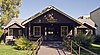
This is a list of the National Register of Historic Places listings in Albany County, Wyoming. It is intended to be a complete list of the properties and districts on the National Register of Historic Places in Albany County, Wyoming, United States. The locations of National Register properties and districts for which the latitude and longitude coordinates are included below, may be seen in a map.

<span class="mw-page-title-main">National Register of Historic Places listings in Crook County, Wyoming</span>

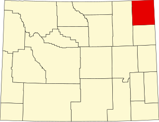
This is a list of the National Register of Historic Places listings in Crook County, Wyoming.

<span class="mw-page-title-main">National Register of Historic Places listings in Carbon County, Wyoming</span>

This is a list of the National Register of Historic Places listings in Carbon County, Wyoming.

<span class="mw-page-title-main">National Register of Historic Places listings in Fremont County, Wyoming</span>

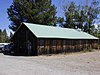
This is a list of the National Register of Historic Places listings in Fremont County, Wyoming.

<span class="mw-page-title-main">National Register of Historic Places listings in Hot Springs County, Wyoming</span>

This is a list of the National Register of Historic Places listings in Hot Springs County, Wyoming. It is intended to be a complete list of the properties and districts on the National Register of Historic Places in Hot Springs County, Wyoming, United States. The locations of National Register properties and districts for which the latitude and longitude coordinates are included below, may be seen in a map.

<span class="mw-page-title-main">National Register of Historic Places listings in Lincoln County, Wyoming</span>

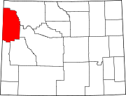
This is a list of the National Register of Historic Places listings in Lincoln County, Wyoming.

<span class="mw-page-title-main">National Register of Historic Places listings in Laramie County, Wyoming</span>

This is a list of the National Register of Historic Places listings in Laramie County, Wyoming. It is intended to be a complete list of the properties and districts on the National Register of Historic Places in Laramie County, Wyoming, United States. The locations of National Register properties and districts for which the latitude and longitude coordinates are included below, may be seen in a map.

<span class="mw-page-title-main">National Register of Historic Places listings in Niobrara County, Wyoming</span>

This is a list of the National Register of Historic Places listings in Niobrara County, Wyoming. It is intended to be a complete list of the properties and districts on the National Register of Historic Places in Niobrara County, Wyoming, United States. The locations of National Register properties and districts for which the latitude and longitude coordinates are included below, may be seen in a map.

<span class="mw-page-title-main">National Register of Historic Places listings in Natrona County, Wyoming</span>

This is a list of the National Register of Historic Places listings in Natrona County, Wyoming.

<span class="mw-page-title-main">National Register of Historic Places listings in Platte County, Wyoming</span>

This is a list of the National Register of Historic Places listings in Platte County, Wyoming.

<span class="mw-page-title-main">National Register of Historic Places listings in Sublette County, Wyoming</span>

This is a list of the National Register of Historic Places listings in Sublette County, Wyoming. It is intended to be a complete list of the properties and districts on the National Register of Historic Places in Sublette County, Wyoming, United States. The locations of National Register properties and districts for which the latitude and longitude coordinates are included below, may be seen in a map.

<span class="mw-page-title-main">National Register of Historic Places listings in Sweetwater County, Wyoming</span>

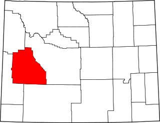
This is a list of the National Register of Historic Places listings in Sweetwater County, Wyoming.

<span class="mw-page-title-main">National Register of Historic Places listings in Uinta County, Wyoming</span>

This is a list of the National Register of Historic Places listings in Uinta County, Wyoming.

<span class="mw-page-title-main">National Register of Historic Places listings in Weston County, Wyoming</span>

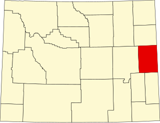
This is a list of the National Register of Historic Places listings in Weston County, Wyoming. It is intended to be a complete list of the properties and districts on the National Register of Historic Places in Weston County, Wyoming, United States. The locations of National Register properties and districts for which the latitude and longitude coordinates are included below, may be seen in a map.

<span class="mw-page-title-main">National Register of Historic Places listings in Sheridan County, Wyoming</span>

This is a list of the National Register of Historic Places listings in Sheridan County, Wyoming. It is intended to be a complete list of the properties and districts on the National Register of Historic Places in Sheridan County, Wyoming, United States. The locations of National Register properties and districts for which the latitude and longitude coordinates are included below, may be seen in a map.

<span class="mw-page-title-main">National Register of Historic Places listings in Teton County, Idaho</span>

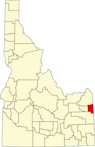
This is a list of the National Register of Historic Places listings in Teton County, Idaho.

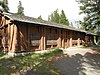
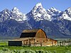
This is a list of the National Register of Historic Places listings in Grand Teton National Park.

This is a list of the National Register of Historic Places listings in Yellowstone National Park.

<span class="mw-page-title-main">National Register of Historic Places listings in Wyoming County, West Virginia</span>

This is a list of the National Register of Historic Places listings in Wyoming County, West Virginia.

References

  1. National Park Service, United States Department of the Interior, "National Register of Historic Places: Weekly List Actions", retrieved July 7, 2023.
  2. 1 2 Numbers represent an alphabetical ordering by significant words. Various colorings, defined here, differentiate National Historic Landmarks and historic districts from other NRHP buildings, structures, sites or objects.
  3. The eight-digit number below each date is the number assigned to each location in the National Register Information System database, which can be viewed by clicking the number.
  4. https://jpritch.public.iastate.edu/homepage_files/GTNP%20Cabin%20Report%20AMK%20Ann.htm [ dead link ]
  5. "Leek's Lodge Chimney". List of Classified Structures. National Park Service. Archived from the original on 1 June 2012. Retrieved 19 November 2009.