National Register of Historic Places listings in Laramie County, Wyoming
Last updated
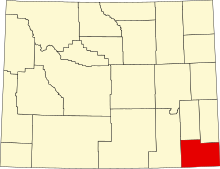
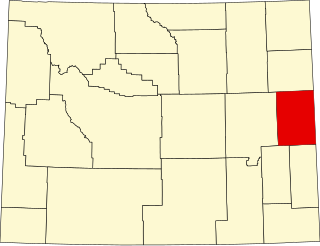
Location of Laramie County in Wyoming
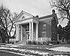
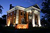
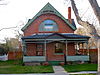
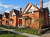
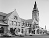
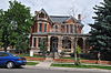
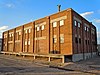
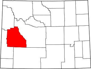
This is a list of the National Register of Historic Places listings in Laramie County, Wyoming. It is intended to be a complete list of the properties and districts on the National Register of Historic Places in Laramie County, Wyoming, United States. The locations of National Register properties and districts for which the latitude and longitude coordinates are included below, may be seen in a map.[1]
There are 56 properties and districts listed on the National Register in the county, 4 of which are National Historic Landmarks. One property was listed but has since been removed.
List of the National Register of Historic Places listings in Wyoming County, New York
This is a list of the National Register of Historic Places listings in Wyoming County, Pennsylvania.
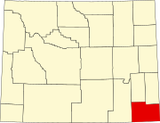
This is a list of the National Register of Historic Places listings in Albany County, Wyoming. It is intended to be a complete list of the properties and districts on the National Register of Historic Places in Albany County, Wyoming, United States. The locations of National Register properties and districts for which the latitude and longitude coordinates are included below, may be seen in a map.
This is a list of the National Register of Historic Places listings in Carbon County, Wyoming.
This is a list of the National Register of Historic Places listings in Fremont County, Wyoming.
This is a list of the National Register of Historic Places listings in Goshen County, Wyoming. It is intended to be a complete list of the properties and districts on the National Register of Historic Places in Goshen County, Wyoming, United States. The locations of National Register properties and districts for which the latitude and longitude coordinates are included below, may be seen in a map.
This is a list of the National Register of Historic Places listings in Hot Springs County, Wyoming. It is intended to be a complete list of the properties and districts on the National Register of Historic Places in Hot Springs County, Wyoming, United States. The locations of National Register properties and districts for which the latitude and longitude coordinates are included below, may be seen in a map.
This is a list of the National Register of Historic Places listings in Lincoln County, Wyoming.
This is a list of the National Register of Historic Places listings in Niobrara County, Wyoming. It is intended to be a complete list of the properties and districts on the National Register of Historic Places in Niobrara County, Wyoming, United States. The locations of National Register properties and districts for which the latitude and longitude coordinates are included below, may be seen in a map.
This is a list of the National Register of Historic Places listings in Natrona County, Wyoming.
This is a list of the National Register of Historic Places listings in Platte County, Wyoming.
This is a list of the National Register of Historic Places listings in Sublette County, Wyoming. It is intended to be a complete list of the properties and districts on the National Register of Historic Places in Sublette County, Wyoming, United States. The locations of National Register properties and districts for which the latitude and longitude coordinates are included below, may be seen in a map.
This is a list of the National Register of Historic Places listings in Sweetwater County, Wyoming.
This is a list of the National Register of Historic Places listings in Uinta County, Wyoming.
This is a list of the National Register of Historic Places listings in Weston County, Wyoming. It is intended to be a complete list of the properties and districts on the National Register of Historic Places in Weston County, Wyoming, United States. The locations of National Register properties and districts for which the latitude and longitude coordinates are included below, may be seen in a map.
This is a list of the National Register of Historic Places listings in Campbell County, Wyoming. It is intended to be a complete list of the properties and districts on the National Register of Historic Places in Campbell County, Wyoming, United States. The locations of National Register properties and districts for which the latitude and longitude coordinates are included below, may be seen in a map.
This is a list of the National Register of Historic Places listings in Sheridan County, Wyoming. It is intended to be a complete list of the properties and districts on the National Register of Historic Places in Sheridan County, Wyoming, United States. The locations of National Register properties and districts for which the latitude and longitude coordinates are included below, may be seen in a map.
This is a list of the National Register of Historic Places listings in Grand Teton National Park.
This is a list of the National Register of Historic Places listings in Wyoming County, West Virginia.
This is a list of the National Register of Historic Places listings in Morrill County, Nebraska.
References
↑ The latitude and longitude information provided in this table was derived originally from the National Register Information System, which has been found to be fairly accurate for about 99% of listings. Some locations in this table may have been corrected to current GPS standards.
1 2 Numbers represent an alphabetical ordering by significant words. Various colorings, defined here, differentiate National Historic Landmarks and historic districts from other NRHP buildings, structures, sites or objects.
↑ The eight-digit number below each date is the number assigned to each location in the National Register Information System database, which can be viewed by clicking the number.
This page is based on this Wikipedia article Text is available under the CC BY-SA 4.0 license; additional terms may apply. Images, videos and audio are available under their respective licenses.