Deforestation or forest clearance is the removal of a forest or stand of trees from land that is then converted to non-forest use. Deforestation can involve conversion of forest land to farms, ranches, or urban use. The most concentrated deforestation occurs in tropical rainforests. About 31% of Earth's land surface is covered by forests at present. This is one-third less than the forest cover before the expansion of agriculture, a half of that loss occurring in the last century. Between 15 million to 18 million hectares of forest, an area the size of Bangladesh, are destroyed every year. On average 2,400 trees are cut down each minute.

Reforestation is the natural or intentional restocking of existing forests and woodlands (forestation) that have been depleted, usually through deforestation, but also after clearcutting.

Illegal logging is the harvest, transportation, purchase or sale of timber in violation of laws. The harvesting procedure itself may be illegal, including using corrupt means to gain access to forests; extraction without permission, or from a protected area; the cutting down of protected species; or the extraction of timber in excess of agreed limits. Illegal logging is a driving force for a number of environmental issues such as deforestation, soil erosion and biodiversity loss which can drive larger scale environmental crisis such as climate change and other forms of environmental degradation.

Although tropical Africa is mostly familiar to the West for its rainforests, this biogeographic realm of Africa is far more diverse. While the tropics are thought of as regions with hot moist climates, which are caused by latitude and the tropical rain belt, the geology of areas, particularly mountain chains, and geographical relation to continental and regional scale winds impact the overall areas, also, making the tropics run from arid to humid in West Africa. The area is currently experiencing the negative effects of rapid human population growth.

Land clearing in Australia describes the removal of native vegetation and deforestation in Australia. Land clearing involves the removal of native vegetation and habitats, including the bulldozing of native bushlands, forests, savannah, woodlands and native grasslands and the draining of natural wetlands for replacement with agriculture, urban and other land uses.

Brazil once had the highest deforestation rate in the world and in 2005 still had the largest area of forest removed annually. Since 1970, over 700,000 square kilometres (270,000 sq mi) of the Amazon rainforest have been destroyed. In 2001, the Amazon was approximately 5,400,000 square kilometres (2,100,000 sq mi), which is only 87% of the Amazon's original size. According to official data, about 729,000 km² have already been deforested in the Amazon biome, which corresponds to 17% of the total. 300,000 km2 have been deforested in the last 20 years.
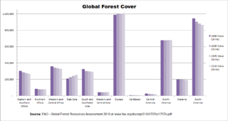
Rates and causes of deforestation vary from region to region around the world. In 2009, 2/3rds of the world's forests were located in just 10 countries: 1) Russia, 2) Brazil, 3) Canada, 4) The United States, 5) China, 6) Australia, 7) The Democratic Republic of the Congo, 8) Indonesia, 9) India, and 10) Peru.
Deforestation in New Zealand has been a contentious environmental issue in the past, but native forests now have legal protection, and are not allowed to be tampered with by humans.

Deforestation in Indonesia involves the long-term loss of forests and foliage across much of the country; it has had massive environmental and social impacts. Indonesia is home to some of the most biologically diverse forests in the world and ranks third in number of species behind Brazil and the Democratic Republic of Congo.

Deforestation in Borneo has taken place on an industrial scale since the 1960s. Borneo, the third largest island in the world, divided between Indonesia, Malaysia and Brunei, was once covered by dense tropical and subtropical rainforests.

Central American countries have experienced cycles of deforestation and reforestation since the decline of Maya civilization, influenced by many factors such as population growth, agriculture, narcotic distribution and illegal practices. From 2001 to 2010, 5,376 square kilometres (2,076 sq mi) of forest were lost in the region. In 2010 Belize had 63% of remaining forest cover, Costa Rica 46%, Panama 45%, Honduras 41%, Guatemala 37%, Nicaragua 29%, and El Salvador 21%. Most of the loss occurred in the moist forest biome, with 12,201 square kilometers. Woody vegetation loss was partially set off by a plus in the coniferous forest biome with 4,730 km2, and at 2,054 km2. Mangroves and deserts contributed only 1% to the loss in forest vegetation. The bulk of the deforestation was located at the Caribbean slopes of Nicaragua with a minus of 8,574 square kilometers of forest lost in the period from 2001 to 2010. The most significant regrowth of 3,050 km2 of forest was seen in the coniferous woody vegetation of Honduras.
Kenya's forests are fragmented across the country, combined, forests cover over 37 million hectares. Out of those 37 million hectares, 2.1 million are woodlands, 24.8 million are bush lands and 10.7 are wooded grasslands. Kenya's forests are important at a global level as they host 1847 species of amphibians, birds, mammals, and reptiles of which 4% are only found in Kenya. Beyond its fauna, Kenya's forest also hosts 6505 types of vascular plants, with 4.1% only being found in Kenya. Today Kenya faces high rates of deforestation which endanger both its fauna and flora. It has been estimated that since Kenya's independence in 1963 the forest cover has dropped from 10% of the nation to 6%, losing approximately 12,000 hectares annually. These levels of deforestation have impacted Kenya as they rely on the forest for the storage of rainwater, the prevention of flooding, the fertility of the soil, and the regulation of climate conditions. The World War II period and its aftermath made it clear to British colonial administration that reform was needed to sustain Kenyan forests. One of the first steps for conservation took place with the 1941 revision of the Forest Ordinance that passed legislation to create forest reserves and create a committee with professionals on matters of conservation. By 1950 the forest department had gained control of 100,000 acres, but it had a difficult time sustaining the conservation of these areas; it required meaningful policy to meet the constant attention these areas needed.

Deforestation in the Democratic Republic of the Congo (DRC) is an environmental conflict of international importance. Most of the deforestation takes place in the Congo Basin, which holds the second largest rainforest of the world after the Amazon. Roughly fifty percent of the remaining rainforest in the Congo Basin lies within the boundaries of the DRC.
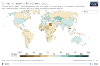
Deforestation is a primary contributor to climate change. Land use changes, especially in the form of deforestation, are the second largest anthropogenic source of atmospheric carbon dioxide emissions, after fossil fuel combustion. Greenhouse gases are emitted during combustion of forest biomass and decomposition of remaining plant material and soil carbon. Global models and national greenhouse gas inventories give similar results for deforestation emissions. As of 2019, deforestation is responsible for about 11% of global greenhouse gas emissions. Carbon emissions from tropical deforestation are accelerating. Peatland degradation also emits GHG. Growing forests are a carbon sink with additional potential to mitigate the effects of climate change. Some of the effects of climate change, such as more wildfires, may increase deforestation. Deforestation comes in many forms: wildfire, agricultural clearcutting, livestock ranching, and logging for timber, among others. The vast majority of agricultural activity resulting in deforestation is subsidized by government tax revenue. Forests cover 31% of the land area on Earth and annually 75,700 square kilometers of the forest is lost. According to the World Resources Institute, there was a 12% increase in the loss of primary tropical forests from 2019 to 2020. Mass deforestation continues to threaten tropical forests, their biodiversity, and the ecosystem services they provide. The main area of concern of deforestation is in tropical rain forests since they are home to the majority of the planet's biodiversity.
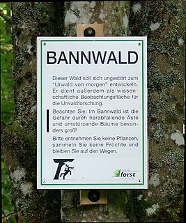
Bannwald is a German word used in parts of Germany and Austria to designate an area of protected forest. Its precise meaning has varied by location and over time.

The history of the forest in Central Europe is characterised by thousands of years of exploitation by people. Thus a distinction needs to be made between the botanical natural history of the forest in pre- and proto-historical times—which falls mainly into the fields of natural history and Paleobotany—and the onset of the period of sedentary settlement which began at the latest in the Neolithic era in Central Europe - and thus the use of the forest by people, which is covered by the disciplines of history, archaeology, cultural studies and ecology.
A Wildbann in the Holy Roman Empire was a specific form of royal hunting privilege.

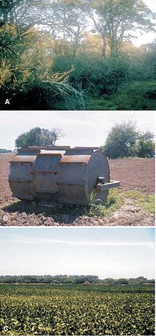
Hauberg is a type of communal forest management that is typical of the Siegerland and adjacent parts of the Lahn-Dill Uplands and the Westerwald in central Germany. Its aim is to manage the forest in order to produce tanbark and charcoal for the regionally important iron ore industry as well as firewood. In addition to forestry uses, the area also has agricultural uses, such as the growing of rye and buckwheat, typical of shifting cultivation, in the year after the timber harvest, as well as subsequent communal grazing (commons).

Hambach Forest is an ancient forest located near Buir in North Rhine-Westphalia, western Germany, between Cologne and Aachen. It was planned to be cleared as part of the Hambach surface mine by owner RWE AG. There were protests and occupations from 2012 against this, and in 2020 a law was passed to preserve it.

The forest in Germany covers 11.4 million hectares, 32 percent of the total area of the country. In the German forests grow about 90 billion young and old trees with a total wood stock of 3.7 billion cubic meters. The definition of the Federal Forest Act (BWaldG) for forest is: "any area planted with forest plants. Forest also includes clear-cut or shaded ground areas, forest roads, forest clearance and securing strips, forest meadows and clearings, forest meadows, grass clearing areas, wood storage areas and other areas associated with and serving the forest."