Clemenceau, Cottonwood

Last updated

Clemenceau, Arizona
ClemenceauBank.jpg
The Bank of Clemenceau, founded 1918. The bank building is preserved on the grounds of the Clemenceau Heritage Museum.
USA Arizona location map.svg
Red pog.svg
Clemenceau, Arizona
Location in the state of Arizona
Coordinates: 34°43′55″N112°01′36″W / 34.73194°N 112.02667°W / 34.73194; -112.02667
Country United States
State Arizona
County Yavapai
Elevation
[1]
3,471 ft (1,058 m)
Time zone UTC-7 (MST (no DST))
Bank of Clemenceau 2018 Cottonwood-Bank of Clemenceau-1918.jpg
Bank of Clemenceau 2018

Clemenceau is a neighborhood of the city of Cottonwood in Yavapai County, Arizona, United States. It was built as a company town in 1917 to serve the new smelter for James Douglas, Jr.'s United Verde Extension Mine (UVX) in Jerome. [2] The town was originally named Verde after the mine, but it was changed to Clemenceau in 1920 in honor of the French premier in World War I, Georges Clemenceau, a personal friend of Douglas. Clemenceau would later leave a vase designed by the French potter Ernest Chaplet to the town in return. [1]

Contents

History

Originally named Verde, the town was renamed Clemenceau in 1920, both to honor Georges Clemenceau and to avoid possible confusion with nearby Camp Verde. Though now a part of the city of Cottonwood, Verde as it was known had its own post office and station on the Clarkdale branch of the Atchison, Topeka & Santa Fe Railroad. [3] "Actual construction of Verde, the United Verde Extension's smelter town in the valley, will probably be under way by January 1," the Jerome News reported on November 9, 1917. "The company will not begin work on its proposed Hogback town, at the east edge of Jerome, before summer at the earliest, and probably not then. So stated General Manager George Kingdon today in a general discussion of the U. V. Extension building plans." [4]

The smelter town had homes for workers, a school, bank, and a clubhouse, and its population varied between 1,000 and 5,000. To deliver ore to the smelter from Jerome, Douglas built the Arizona-Extension Railway, a two-branch shortline railroad. The western branch ran between Clemenceau and the eastern portal of the 2.5-mile (4.0 km) Josephine Tunnel, which connected to the UVX Mine. The eastern branch ran between Clemenceau and Clarkdale. [2]

On July 16, 1918, Verde was the scene of a violent confrontation when a handful of Mexican laborers collided with area lawmen attempting to enforce the War Department's so called "work or fight order" during World War I. Former Yavapai County Sheriff James R. Lowry, then serving as a deputy sheriff at the smelter, was shot and killed during the incident. His assailant was later killed during an exchange of gunfire with an off-duty peace officer near Camp Verde. [5]

The Clemenceau smelter closed in 1937. Most residents then left the area. When Cottonwood was incorporated in 1960, Clemenceau and the Clemenceau Airport were included in its boundaries. [6]

With the exception of the school, the bank/post office and the smelter slag pile, little remains of the original town of Clemenceau. A largely invisible remnant is the Clemenceau Water Company, which still serves the area of the old town of Clemenceau. The town of Cottonwood bought the company in 2004, but it still operates as a separate entity, as of 2006.

Clemenceau Heritage Museum

The Clemenceau Heritage Museum occupies most of the old Clemenceau School, which operated from 1924 through 1986. [7] The 1918 Clemenceau Bank and Post Office building is also part of the museum. [6] The museum has displays on mining, ranching, and farming in the Verde Valley, and preserves archives and artifacts from the area. [8] An elaborate working model-railroad display depicts the nine railroads that once operated in the region. [9]

Douglas and Clemenceau

James Douglas, Jr., bought an apartment in Paris for his friend, Georges Clemenceau, in 1926, for his retirement home. This building later became the Musée Clemenceau. [10]

Notable residents and visitors

Jack Frye's personal airplane, a TWA Lockheed Model 10 Electra with tail number NC18137, was frequently based at the Clemenceau Airport. [11] Frye had a vacation ranch near Sedona, now Red Rock State Park.

Related Research Articles

<span class="mw-page-title-main">Clarkdale, Arizona</span> Town in Yavapai County, Arizona

Clarkdale is a town in Yavapai County, Arizona, United States. The Verde River flows through the town as does Bitter Creek, an intermittent tributary of the river. According to the 2021 census, the population of the town was 4,419.

<span class="mw-page-title-main">Cornville, Arizona</span> CDP in Yavapai County, Arizona

Cornville is a census-designated place (CDP) in Yavapai County, Arizona, United States. The population as of the 2010 United States Census was 3,280, down from 3,335 at the 2000 census. For statistical purposes, the United States Census Bureau has defined Cornville as a CDP that includes the unincorporated communities of Cornville and Page Springs.

<span class="mw-page-title-main">Jerome, Arizona</span> Town in Yavapai County, Arizona, US

Jerome is a town in the Black Hills of Yavapai County in the U.S. state of Arizona. Founded in the late 19th century on Cleopatra Hill overlooking the Verde Valley, Jerome is located more than 5,000 feet (1,500 m) above sea level. It is about 100 miles (160 km) north of Phoenix along State Route 89A between Sedona and Prescott. Supported in its heyday by rich copper mines, it was home to more than 10,000 people in the 1920s. As of the 2010 census, its population was 444. It is now known for its tourist attractions, such as its "ghost town" status and local wineries.

<span class="mw-page-title-main">Mingus Mountain</span> Mountain in Arizona, United States

Mingus Mountain is a mountain located in the U.S. state of Arizona in the Black Hills mountain range. It is located within the Prescott National Forest traversed by State Route 89A approximately midway between Cottonwood and Prescott. The summit can be reached via Forest Service roads that branch off from State Route 89A. From the mountain, there are views of the Verde Valley, Sycamore Canyon Wilderness and the towns of Cottonwood, Jerome, and Clarkdale. The Woodchute Wilderness, north of the summit of 89A, also offers views and hiking trails. There are several National Forest campgrounds in the area and it is the transmitter location for Prescott full-service television station KAZT-TV and several low-power television stations serving Cottonwood, Clarkdale, Camp Verde and Prescott Valley. Mingus Mountain is also the premier flying site of the Arizona Hang Gliding and Paragliding Association.

<span class="mw-page-title-main">Verde Valley</span> Valley in central Arizona, US

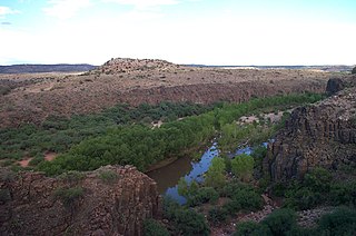
The Verde Valley is a valley in central Arizona in the United States. The Verde River runs through it. The Verde River is one of Arizona's last free-flowing river systems. It provides crucial habitat for fish and wildlife, fresh water for local agricultural production, recreational opportunities for locals and tourists alike, and brings clean drinking water to over 2 million people in the greater Phoenix area. The valley is overlooked by Mingus Mountain and the Mogollon Rim. The valley is one of three regions of viticulture in Arizona and contains the Verde Valley AVA.

<span class="mw-page-title-main">Arizona State Route 89A</span> State highway in Arizona, United States

State Route 89A is an 83.85-mile (134.94 km) state highway that runs from Prescott north to Flagstaff in the U.S. state of Arizona. The highway begins at SR 89 in Yavapai County and heads northward from Prescott Valley, entering Jerome. From Jerome, the route then heads to Cottonwood and Clarkdale. The road then continues out to Sedona. The highway is notable for its scenic value as it winds over and through Mingus Mountain as well as passing through Sedona and the Oak Creek Canyon. The route then enters Coconino County soon after leaving Sedona. The highway proceeds to Flagstaff, where it crosses Interstate 17 (I-17) and I-40. The highway ends at I-40 Business in Flagstaff. What is now SR 89A became a state highway in the late 1920s as SR 79. The highway was extended and improved several times through 1938. SR 79 was renumbered to U.S. Route 89A in 1941 and then to SR 89A in the early 1990s.

<span class="mw-page-title-main">Verde Canyon Railroad</span> Heritage railroad in Arizona

The Verde Canyon Railroad is a heritage railroad running between Clarkdale and Perkinsville in the U.S. state of Arizona. The passenger excursion line operates on 20 miles (32 km) of tracks of the Clarkdale Arizona Central Railroad (AZCR), a shortline. The Verde Canyon Railroad has its depot, headquarters, and a railway museum in Clarkdale, about 25 miles (40 km) southwest of Sedona.

<span class="mw-page-title-main">James Douglas (businessman)</span> Mining engineer and businessman (1837–1918)

James Walter Douglas was a Canadian born mining engineer and businessman who introduced a number of metallurgical innovations in copper mining and amassed a fortune through the copper mining industry of Bisbee, Arizona Territory and Sonora before and after the turn of the 20th century.

<span class="mw-page-title-main">Jerome State Historic Park</span> Protected area in Yavapai County, Arizona

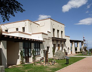
Jerome State Historic Park is a state park of Arizona, US, featuring the Douglas Mansion, built in 1916 by a family of influential mining entrepreneurs in Jerome, Arizona, a mining region in the northeast of the Black Hills, east Yavapai County. A museum is located in the old Douglas Mansion.

<span class="mw-page-title-main">Jerome Historic District</span> Historic district in Arizona, United States

The Jerome Historic District is a National Historic Landmark District encompassing the former mining community of Jerome, Arizona. The town was founded as a mining camp associated with copper deposits that were mined from the late 19th century until 1953. The district was declared a National Historic Landmark in 1966 and was included into the then-new National Register of Historic Places.

Jerome Junction is a ghost town in Yavapai County, Arizona, United States. Established in 1894, the community served as a railroad transfer stop between the town of Prescott and the town of Jerome. It served as a transfer point between the Santa Fe, Prescott and Phoenix Railway (SFP&P) and the narrow-gauge United Verde & Pacific Railway for 25 years. The narrow-gauge line was built precariously on the side of Woodchute Mountain by William A. Clark after he bought the United Verde Copper Company. In 1917 it had a population of 150. When it was replaced by standard-gauge line on the east side of the mountain from Jerome to Clarkdale in 1920, Jerome Junction became a ghost town, and in 1923, the activities of the former town were absorbed by Chino Valley.

<span class="mw-page-title-main">Perkinsville, Arizona</span> Ghost town in Yavapai County, Arizona

Perkinsville, Arizona, is a populated place in Yavapai County, in the U.S. state of Arizona. It is a hamlet about 0.5 miles (0.8 km) from the Perkinsville Bridge over the Verde River.

<span class="mw-page-title-main">Tuzigoot National Monument</span> Historic site in Yavapai County, Arizona, US

Tuzigoot National Monument preserves a 2- to 3-story pueblo ruin on the summit of a limestone and sandstone ridge just east of Clarkdale, Arizona, 120 feet (37 m) above the Verde River floodplain. The Tuzigoot Site is an elongated complex of stone masonry rooms that were built along the spine of a natural outcrop in the Verde Valley. The central rooms stand higher than the others and they appear to have served public functions. The pueblo has 110 rooms. The National Park Service currently administers 58 acres, within an authorized boundary of 834 acres.

<span class="mw-page-title-main">Cottonwood-Oak Creek School District</span> School district in Yavapai County, Arizona

The Cottonwood-Oak Creek School District No. 6 (COCSD) is a school district in Arizona, United States, headquartered in Cottonwood. The district serves areas in Yavapai County, including Cottonwood and Cornville.

<span class="mw-page-title-main">UVX Mining Co.</span> Historic mining operation in Arizona

The UVX Mining Co., owned by James S. Douglas, Jr., operated the United Verde Extension (UVX) Mine at Jerome and built a copper smelter complex at Clemenceau (Cottonwood) in the U.S. state of Arizona. The complex, operational from 1917 through 1937, is listed on the National Register of Historic Places.

<span class="mw-page-title-main">United Verde & Pacific Railway</span> Former railroad in Yavapai County, Arizona

The United Verde and Pacific Railway was a 3 ft narrow gauge railroad that operated from 1895 to 1920 in what became Yavapai County in the U.S. state of Arizona. William A. Clark built the 26-mile (42 km) line to link his copper mine and smelter in Jerome to an existing branch of the Santa Fe Railway system. Clark eventually replaced the line with three 4 ft 8+12 instandard gauge rail lines after building a new smelter and company town in Clarkdale.

Vera Brown Starr was the first woman elected as chair of the Yavapai-Apache Nation and served two years in the office, as well as serving over fifteen years on the council. She was one of the delegates to the 1977 National Women's Conference, a major U.S. women's conference held in conjunction with the International Women's Year celebrations of the United Nations. In 2012, her name was inscribed on an arch recognizing women who were Native American leaders at the University of Arizona.

References

  1. 1 2 "Clemenceau". Geographic Names Information System. United States Geological Survey. June 27, 1984. Retrieved December 5, 2012.
  2. 1 2 Wahmann, Russell (1999). Verde Valley Railroads: Trestles, Tunnels & Tracks. Jerome, Arizona: Jerome Historical Society. pp. 61–62. ISBN   0-9621000-4-8.
  3. Barnes, Will C. Arizona Place Names (University of Arizona Press, 1988)
  4. The Jerome News; Friday, November 9, 1917
  5. Dolan, Samuel K. Cowboys and Gangsters: Stories of an Untamed Southwest (TwoDot Books, 2016) ISBN   978-1-4422-4669-0
  6. 1 2 "History". Verde Historical Society. Retrieved December 6, 2012.
  7. "Clemenceau Heritage Museum". Verde Historical Society. Retrieved December 5, 2012.
  8. "Exhibits". Verde Historical Society. Retrieved December 6, 2012.
  9. "All Aboard". Verde Historical Society. Retrieved December 6, 2012.
  10. "Museum History". Musée Clemenceau. Archived from the original on October 14, 2012. Retrieved December 6, 2012.
  11. "TWA's Flight Research Laboratory at Clemenceau". Arizona State Library. Archived from the original on July 18, 2011. Retrieved May 12, 2009.