Cloneen | |
|---|---|
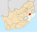
| Coordinates: 27°54′07″S30°09′25″E / 27.902°S 30.157°E Coordinates: 27°54′07″S30°09′25″E / 27.902°S 30.157°E | |
| Country | South Africa |
| Province | KwaZulu-Natal |
| District | Amajuba |
| Municipality | Dannhauser |
| Area | |
| • Total | 8.99 km2 (3.47 sq mi) |
| Population (2011) [1] | |
| • Total | 4,360 |
| • Density | 480/km2 (1,300/sq mi) |
| Racial makeup (2011) | |
| • Black African | 99.3% |
| • Coloured | 0.2% |
| • Indian/Asian | 0.4% |
| • White | 0.1% |
| First languages (2011) | |
| • Zulu | 95.5% |
| • English | 1.1% |
| • S. Ndebele | 1.0% |
| • Other | 2.5% |
| Time zone | UTC+2 (SAST) |
| PO box | 3080 |
Cloneen is a town in Dannhauser Local Municipality in the KwaZulu-Natal province of South Africa.

Dannhauser Local Municipality is an administrative area in the Amajuba District of KwaZulu-Natal in South Africa. The municipality is named after Renier Dannhauser, a German settler who in 1872 purchased four farms in the area from the then owner, the Natal government.

KwaZulu-Natal is a province of South Africa that was created in 1994 when the Zulu bantustan of KwaZulu and Natal Province were merged. It is located in the southeast of the country, enjoying a long shoreline beside the Indian Ocean and sharing borders with three other provinces and the countries of Mozambique, Eswatini and Lesotho. Its capital is Pietermaritzburg and its largest city is Durban. It is the 2nd most populous province in South Africa, with slightly fewer residents than Gauteng.

South Africa, officially the Republic of South Africa (RSA), is the southernmost country in Africa. It is bounded to the south by 2,798 kilometres (1,739 mi) of coastline of Southern Africa stretching along the South Atlantic and Indian Oceans; to the north by the neighbouring countries of Namibia, Botswana, and Zimbabwe; and to the east and northeast by Mozambique and Eswatini (Swaziland); and it surrounds the enclaved country of Lesotho. South Africa is the largest country in Southern Africa and the 25th-largest country in the world by land area and, with over 57 million people, is the world's 24th-most populous nation. It is the southernmost country on the mainland of the Old World or the Eastern Hemisphere. About 80 percent of South Africans are of Sub-Saharan African ancestry, divided among a variety of ethnic groups speaking different African languages, nine of which have official status. The remaining population consists of Africa's largest communities of European (White), Asian (Indian), and multiracial (Coloured) ancestry.


