Colenso is a town in KwaZulu-Natal, South Africa. It is located on the southern bank of the Tugela River on the R103 road. The original settlement was contained within a loop on the river, but it subsequently expanded southwards and eastwards. It lies on the main Durban - Johannesburg railway line some 190 km (118 mi) north-west of Durban.

Radisson is a small unconstituted locality situated near the Robert-Bourassa hydroelectric power station on the La Grande River in the James Bay region of Quebec, Canada. Geographically, Radisson is located halfway between the southern and northernmost points in Quebec and is, besides Schefferville, the only non-native town north of the 53rd parallel in this province.
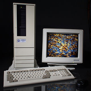
The Amiga 4000T, also known as A4000T, is a tower version of Commodore's A4000 personal computer. Using the AGA chipset, it was originally released in small quantities in 1994 with a 25 MHz Motorola 68040 CPU, and re-released in greater numbers by Escom in 1995, after Commodore's demise, along with a new variant which featured a 50 MHz Motorola 68060 CPU. Despite the subsequent demise of Escom, production was continued by QuikPak in North America into at least 1998.

Mangalore Electricity Supply Company Limited is an Indian electricity supplier to the districts of Karnataka namely Dakshina Kannada, Udupi district, Chickmagalur and Shimoga. It has its headquarters at Mangaluru. The company was formed on June 2002.
École Supérieure de Chimie Organique et Minérale (ESCOM) is a French grande école located in Compiègne, France. It is a private school founded in 1957.
Escom or ESCOM may refer to:
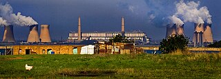
Hendrina Power Station in Mpumalanga, South Africa, is one of South Africa's oldest operating power stations.

The Amiga 1200, or A1200, is a personal computer in the Amiga computer family released by Commodore International, aimed at the home computer market. It was launched on October 21, 1992, at a base price of £399 in the United Kingdom and $599 in the United States.
The Nkhula B Hydroelectric Power Station, also Nkula B Hydroelectric Power Station is a hydroelectric power plant on the Shire River in Malawi. It has a power generating capacity of 100 megawatts (130,000 hp).

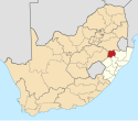
Colenso Power Station was a South African coal-fired power station, located in Colenso, KwaZulu-Natal on the banks of the Tugela River. It was built in the 1920s by the South African Railways to supply electricity for the railways, and was subsequently sold to the Electricity Supply Commission (Eskom).
Bharathnagar is a well planned residential layout in the city of Bangalore, India. Located off the arterial Magadi Road and approximately 13 km (8.1 mi) from the Bangalore Central Railway station, this layout was primarily created for the employees of the public sector giant Bharat Electronics Limited. Bharathnagar is divided into Phase 1 & 2. Phase 2 is the larger of the two and has the capacity to accommodate 4000 independent homes, whereas Phase 1 can accommodate 2,000 homes. Bharathnagar was carved out of the larger village of Byadarahalli.
Electricity Supply Corporation of Malawi Limited (ESCOM) is the state-owned power transmission and distribution company in Malawi. It is entirely in control of transmission and distribution of electric power in the country. ESCOM represents Malawi in the Southern African Power Pool. It should not be confused with its South African equivalent Eskom.
The Nkhula A Hydroelectric Power Station, also Nhula A Hydroelectric Power Station, is a hydroelectric power plant on the Shire River in Malawi. It has an installed capacity of 36 megawatts (48,000 hp), with three 12 megawatts (16,000 hp) generating sets. The power was developed in stages, with the first phase involving the installation of three 8 megawatts-generating turbines. Phase I of the power station was officially opened in 1966.
The Wovwe Hydroelectric Power Station, also Wovwe Power Station, is a hydroelectric power plant on the Wovwe River in Malawi. It has installed capacity of 4.35 megawatts (5,830 hp), with three generation units of 1.45 megawatts each.
Burning of charcoal and wood fuel provides approximately 94 percent of the energy in Malawi. Much of the renewable hydroelectric potential of the country is untapped. As per 2018 Population and Housing Census, the national electrification rate in Malawi was 10%, with 37% of the urban population and only 2% of the rural population having access to electricity.
The Electricity Generation Company Malawi Limited (Egenco) is a parastatal company whose primary purpose is to generate electric power for use in Malawi and for possible sale to neighboring countries. As of April 2018, Egenco's generation capacity was 351 megawatts (471,000 hp). In May 2021, Egenco's generation portfolio increased to 441.55 megawatts (592,130 hp), when the 19 MW Tedzani IV Hydroelectric Power Station, was brought online.
The Mpatamanga Hydro Power Project, is a 361MW hydroelectric generating project under developpement at Mpatamanga on the Shire River, in Malawi
Kanzimbe Solar Power Station, is a 60 megawatts (80,000 hp) solar power plant, in Malawi, in Southern Africa. The power station was constructed between December 2018 and November 2021.
The Bwengu Solar Power Station is a 50 megawatts solar power plant, under construction in Malawi. The power station is under development by a consortium led by Quantel Renewable Energy, an independent power producer (IPP), based in the United States. Construction began in February 2022, with commercial commissioning expected in the first quarter of 2023. The energy generated at this solar farm is expected to be sold to the Electricity Supply Corporation of Malawi (ESCOM), under a long-term power purchase agreement (PPA).