Clonmines

Last updated

Clonmines is a civil parish and townland in the Bannow Bay area of County Wexford, [1] Ireland, the site of "the finest example in Ireland of a deserted medieval borough". [2] It is situated in the barony of Shelburne, southwest of Wellingtonbridge on the northwest shore of Bannow Bay. [3] The parish of Clonmines contains the townland of the same name and the smaller townland of Arklow, [4] with respective areas of 1,258 acres (509 ha) and 127 acres (51 ha). [5] [6]

Contents

History

There is evidence of a Norse-Gaelic settlement in Bannow in general and Clonmines in particular. [7] In the early thirteenth century, after the Norman conquest of Ireland, a borough and port was established at Clonmines by William Marshal. [7] [8] Colfer suggests that Marshal chose the site in spite of its shallow harbour and poor hinterland, to offer a sheltered winter port alternative to New Ross. [9] After the partition of Marshal's Lordship of Leinster around 1249, Clonmines was a detached manor of the liberty of Kildare. [10]

It was a notable town with a provost and bailiff in the fourteenth century, and still considered a town in the sixteenth. [11] In 1552, king Edward VI funded a scheme to mine silver in nearby Barrystown, which was abandoned after five months. [12] The name "Clonmines" predates these mines; [13] its origin is uncertain. [1] Herbert F. Hore in 1859 suggested the Irish Cluainmain "Ecclesiastical retreat on the plains". [13]

Patrick Weston Joyce in 1913 suggested Cluain-mín, meaning "smooth meadow". [14] T. C. Butler in 1986 suggested Cloch-Maighean, "a stone enclosure around the dwelling of a chief". [15]

Colfer suggests that Clonmines's isolation from the rest of Kildare, and competition from New Ross, contributed to its decline. [10] Sandbars had rendered the port unnavigable by the 17th century. [13] The site was subsequently deserted, and no record exists of any charter. [16] Although Clonmines remains a civil parish, in 1785 the Church of Ireland parish was united by Walter Cope, Bishop of Ferns and Leighlin, with those of Tintern and Owenduff to form the Union of Owen Duff. [17]

Borough

Clonmines Borough was a rotten borough represented in the Irish House of Commons, which shared the same burgesses as nearby Bannow and Fethard. It was disfranchised in 1801 when under the Act of Union 1800 with £15,000 compensation paid to the Marquess of Ely in compensation in respect of each of these. [18] A report into boroughs in Ireland in 1833 found "there is no house at or near the place, except Mr Sutton's ... the population of what was once the borough [consisted] of merely the family of this gentleman". [16]

Ruins

A 1684 account describes the ruins of a church, an abbey, and "4 or 5 ruined Castles"; in the nineteenth century, "the seven castles of Clonmines" were still proverbial, although only some still had visible remains. [3] [13] Colfer in 2004 characterised the remains as two tower houses, one incorporated into a more modern dwelling; a fortified seventeenth-century house; the parish church of Saint Nicholas; another fortified church; and the Augustinian priory. [8] [10] The poorer people's buildings of wood and clay have disappeared. Excavations have revealed traces of the medieval defensive ramparts. The site is private property and not open to the public. [2]

52°15′40″N6°45′57″W / 52.261013°N 6.765701°W / 52.261013; -6.765701 (Clonmines Castle ruins) [19]

Sources

Related Research Articles

<span class="mw-page-title-main">County Carlow</span> County in Ireland

County Carlow is a county located in the Southern Region of Ireland, within the province of Leinster. Carlow is the second smallest and the third least populous of Ireland's 32 traditional counties. Carlow County Council is the governing local authority.

<span class="mw-page-title-main">County Wexford</span> County in Ireland

County Wexford is a county in Ireland. It is in the province of Leinster and is part of the Southern Region. Named after the town of Wexford, it was based on the historic Gaelic territory of Hy Kinsella, whose capital was Ferns. Wexford County Council is the local authority for the county. The population of the county was 163,527 at the 2022 census.

<span class="mw-page-title-main">Ardglass</span> Fishing village in County Down, Northern Ireland

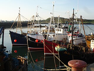
Ardglass is a coastal fishing village, townland and civil parish in County Down, Northern Ireland, in the historic barony of Lecale Lower. It is still a relatively important fishing harbour. It is situated on the B1 Ardglass to Downpatrick road, about 6 miles to the south east of Downpatrick, in the Lecale peninsula on the Irish Sea. It had a population of 1,668 in the 2001 Census, and is located within the Newry, Mourne and Down area.
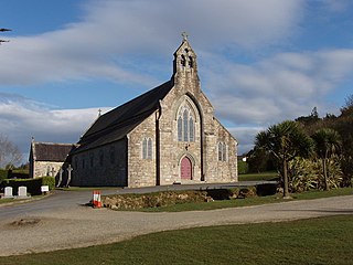
A townland is a small geographical division of land, historically and currently used in Ireland and in the Western Isles in Scotland, typically covering 100–500 acres (40–202 ha). The townland system is of Gaelic origin, antedating the Norman invasion, and most have names of Irish origin. However, some townland names and boundaries come from Norman manors, plantation divisions, or later creations of the Ordnance Survey. The total number of inhabited townlands in Ireland was 60,679 in 1911. The total number recognised by the Irish Place Names database as of 2014 was 61,098, including uninhabited townlands, mainly small islands.

<span class="mw-page-title-main">Synod of Ráth Breasail</span> Irish Catholic synod in 1111

The Synod of Ráth Breasail was a synod of the Catholic Church in Ireland that took place in Ireland in 1111. It marked the transition of the Irish church from a monastic to a diocesan and parish-based church. Many present-day Irish dioceses trace their boundaries to decisions made at the synod.

<span class="mw-page-title-main">Doora, County Clare</span> Village in County Clare, Ireland

Doora is a village and civil parish in County Clare, Ireland, just to the east of the town of Ennis.

<span class="mw-page-title-main">Barntown</span> Village in County Wexford, Ireland

Barntown is a townland and village in County Wexford, Ireland. Located just outside the town of Wexford, as of the 2016 census, Barntown had a population of 459 people.

<span class="mw-page-title-main">Old Leighlin</span>

Old Leighlin, also Oldleighlin, is a village, civil parish and townland in County Carlow, Ireland. The village is 3.5 km (2 mi) west of Leighlinbridge. The site was at one time one of the foremost monastic houses in Leinster, with 1500 monks in residence. It was the location for a church synod in AD 630, which decided that the Irish church should follow Roman as opposed to Celtic dating conventions for determining the date of Easter.

<span class="mw-page-title-main">Roman Catholic Diocese of Kildare and Leighlin</span> Diocese of the Catholic Church

The Diocese of Kildare and Leighlin is a Latin Church diocese of the Catholic Church in eastern Ireland. It is one of three suffragan dioceses in the ecclesiastical province of Dublin and is subject to the Archdiocese of Dublin. On 7 May 2013, Denis Nulty was appointed bishop of the diocese.

<span class="mw-page-title-main">Kilteel</span> Village in County Kildare, Ireland

Kilteel is the name of a village, townland and civil parish located in the barony of South Salt, County Kildare, Ireland. The townland of Kilteel Upper contains the remains of a church with a decorated Romanesque chancel arch, the ruins of a 13th-century preceptory of the Knights Hospitaller and a well-preserved 15th-century tower house. The historic settlement is located on the southwest corner of the English Pale and served an important function as a border fortress during the medieval period.

<span class="mw-page-title-main">Murrintown</span> Village in County Wexford, Ireland

Murrintown, also spelled Murntown, is a small village located in the southeast of County Wexford, in Ireland, close to Wexford town. It is part of the parish of Piercestown.

<span class="mw-page-title-main">Bannow</span> Village in County Wexford, Ireland

Bannow is a village and civil parish lying east of Bannow Bay on the south-west coast of County Wexford, Ireland. In modern times the main settlement is the village of Carrig-on-Bannow. In Norman times there was a borough called Bannow on Bannow Island at the mouth of the Bay. This town has since disappeared, probably due to the silting up of the natural harbour channels in the 14th century, and the former island is now attached to the rest of the parish.

<span class="mw-page-title-main">Drumcliff, County Clare</span> Civil parish in Munster, Ireland

Drumcliff, or Drumcliffe, Dromcliffe is a civil parish in County Clare, Ireland. It includes the village of Inch and part of the town of Ennis.

Harristown is a townland in County Kildare on the River Liffey 2.5 miles (4.0 km) downstream from Kilcullen, just north of Brannockstown in the civil parish of Carnalway in the barony of Naas South. It is the site of a former borough and manor, and Harristown Borough was a borough constituency sending two MPs to the Irish House of Commons before the Acts of Union 1800. Harristown Common is a townland and former commonage north of Harristown proper and separated from it by the townlands of Dunnstown and Johnstown or Dunshane.

<span class="mw-page-title-main">Killone</span> Civil parish in Munster, Ireland

Killone is a civil parish of County Clare, Ireland, to the southwest of Ennis. It is known for the ruins of Killone Abbey.

Donadea is a civil parish in the barony of Ikeathy and Oughterany in the north of County Kildare, Ireland. There are seven townlands in the parish. There are no large centres of population in the parish. Donadea is noted for its public forest park which is one of the most popular outdoor venues in county Kildare. The nearest villages are Staplestown and Prosperous. The parish name is derived from a church, traditionally said to have been founded by Saint Patrick. A small 17th-century church of the Church of Ireland, St Peter's, still exists within the Donadea demesne.

Rathmore, a village, civil parish and District electoral division in County Kildare, Ireland, is located at the western edge of the Wicklow Mountains in the barony of Naas North. The original settlement was at the southwest corner of the English Pale, serving an important function as a border fortress during the medieval period.

<span class="mw-page-title-main">Ardattin</span>

Ardattin is a village and townland in County Carlow, Ireland. It lies in the civil parish of Ardoyne in the historical barony of Forth. As of the 2011 census, the townland had a population of 34 people.

St. Doologe's, also St. Doologue's, and formerly St. Tullogue's, or St. Euleck's, is a civil parish in the centre of Wexford town in Ireland.

<span class="mw-page-title-main">Slade Castle</span> Tower house in County Wexford, Ireland

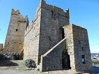
Slade Castle is a tower house and National Monument in County Wexford, Ireland. It is located in the village of Slade on the Hook Peninsula and primarily dates to the late 15th or early 16th century.

References

  1. 1 2 "Clonmines (civil parish)". Placenames Database of Ireland . Retrieved 21 July 2013.
  2. 1 2 Colfer 2004, p. 77.
  3. 1 2 "Map centred on Clonmines Castle". Mapviewer. Ordnance Survey Ireland. Archived from the original on 29 August 2012. Retrieved 21 July 2013.
  4. "Townlands in Clonmines". Placenames Database of Ireland . Archived from the original on 13 October 2013. Retrieved 21 July 2013.
  5. "Wexford". Categories of Disadvantaged Areas. Department of Agriculture, Food and the Marine. Archived from the original (Microsoft Excel) on 19 July 2013. Retrieved 21 July 2013.
  6. "Map of Clonmines parish and townlands". First-edition 6-inch Map. Ordnance Survey Ireland. 1830s. Archived from the original on 29 August 2012. Retrieved 21 July 2013.
  7. 1 2 Colfer 2004, p. 30.
  8. 1 2 Colfer 2004, p. 74.
  9. Colfer 2004, p. 35–37.
  10. 1 2 3 Colfer 2004, p. 39.
  11. Colfer 2004, p. 38.
  12. Williams, Jack (2011). "The Affair at Clonmines". History of Computing: 35–52. doi:10.1007/978-0-85729-862-1_4. ISBN   978-0-85729-861-4. ISSN   2190-6831.
  13. 1 2 3 4 Hore, Herbert F. (1859). "A Chorographic Account of the Southern Part of the County of Wexford, Written Anno 1684: By Robert Leigh, Esq., of Rosegarland, in That County. (Concluded)". The Journal of the Kilkenny and South-East of Ireland Archaeological Society. Royal Society of Antiquaries of Ireland. NS Vol. 2 (2): 455. JSTOR   25502576.
  14. Joyce, Patrick Weston (1913). "Clonmines". Irish names of places. Vol. 3. Dublin: Phoenix. p. 217.
  15. Butler, T.C. (Summer 1986). "Bannow in Pre–Norman Times" (PDF). Decies. Old Waterford Society (32): 10.
  16. 1 2 Commissioners appointed to inquire into the municipal corporations in Ireland (1835). "Clonmines". Appendix to the First Report, Part I: Southern, midland, western and south-eastern circuits, and part of the north-eastern circuit. Command papers. Vol. 27. HMSO. p. 492. Retrieved 21 July 2013.
  17. "(B) Ecclesiastical Reports for 1807, Province of Leinster; (3) Diocese of Leighlin and Ferns". Papers relating to Established Church in Ireland. Command papers. 29 July 1807. p. 178.
  18. "Clonmines". Ulster Historical Foundation. Retrieved 12 April 2023.
  19. "Map centred on Clonmines Castle". Google Maps . Retrieved 21 July 2013.
  20. "Map centred on Clonmines Castle". Google Maps . Retrieved 21 July 2013.