
Washita County is a county located in the U.S. state of Oklahoma. As of the 2020 census, the population was 10,924. Its county seat is New Cordell. The county seat was formerly located in Cloud Chief. The county was created in 1891.

Kiowa County is a county located in the southwestern part of the U.S. state of Oklahoma. As of the 2020 census, the population was 8,509. Its county seat is Hobart. The county was created in 1901 as part of Oklahoma Territory. It was named for the Kiowa people.

Custer County is a county located in the U.S. state of Oklahoma. As of the 2020 census, the population was 28,513. Its county seat is Arapaho. The county was named in honor of General George Armstrong Custer.

Caddo County is a county located in the U.S. state of Oklahoma. As of the 2020 census, the population was 26,945. Its county seat is Anadarko. Created in 1901 as part of Oklahoma Territory, the county is named for the Caddo tribe who were settled here on a reservation in the 1870s. Caddo County is immediately west of the seven-county Greater Oklahoma City metro area, and although is not officially in the metro area, it has many economic ties in this region.

Cheyenne is a town in Roger Mills County, Oklahoma, United States. As of the 2020 census, the town's population was 771. It is the county seat of Roger Mills County.
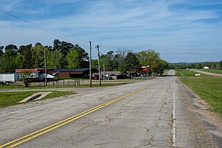
Colony is a town in northeastern Washita County, Oklahoma, United States. The population was 136 at the 2010 U.S. census, a decrease of 7.5 percent from 147 in 2000. It was named for the Seger Colony, founded in 1886, which taught modern agricultural techniques to the Arapaho and Cheyenne tribes that would be resettled in the vicinity. Colony is 16 miles (26 km) east and 4 miles (6.4 km) north of Cordell.

Corn is a town in Washita County, Oklahoma, United States. The population was 503 at the 2010 census.

New Cordell is a city in, and county seat of, Washita County, Oklahoma, United States. It lies along U.S. Route 183. The population was 2,775 at the time of the 2020 Census. The community was previously established a few miles from the current site, but was moved about 1900. It was named for a U.S. Postal Service employee in Washington D. C., Wayne W. Cordell. The official name is New Cordell, though it is now commonly called Cordell.

Sentinel is a town in Washita County, in the U.S. state of Oklahoma. The population was 901 in the 2010 census, an increase of 4.9 percent from the figure of 859 residents in 2000. Towns near Sentinel are Rocky, Cordell, Canute, and Burnsflat.
Eagletown is an unincorporated community and census-designated place in McCurtain County, Oklahoma, United States. The population was 528 at the 2010 census. Located on Mountain Fork River, approximately 6 miles (9.7 km) from the Oklahoma-Arkansas border, it was the first permanent Choctaw settlement in the Indian Territory, who called it o̱ssi tamaha ("Eagle"). Eagletown was an important town from 1834 to 1906, and after 1850, served as county seat for the Choctaw Nation's Eagle County. The town name was officially changed to "Eagle Town" in 1850, then changed to the present Eagletown in 1892. When Indian Territory was preparing to unite with Oklahoma Territory to form the new state of Oklahoma in 1906, Eagletown lost its county seat status and became just another unincorporated community in the new McCurtain County.
Boggy Depot is a ghost town and Oklahoma State Park that was formerly a significant city in the Indian Territory. It grew as a vibrant and thriving town in present-day Atoka County, Oklahoma, United States, and became a major trading center on the Texas Road and the Butterfield Overland Mail route between Missouri and San Francisco. After the Civil War, when the MKT Railroad came through the area, it bypassed Boggy Depot and the town began a steady decline. It was soon replaced by Atoka as the chief city in the area. By the early 20th century, all that remained of the community was a sort of ghost town.

Edwin Durwood Merrill was an American umpire in Major League Baseball (MLB) who worked in the American League for 23 seasons (1977–1999).
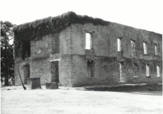
Fort Washita is the former United States military post and National Historic Landmark located in Durant, Oklahoma on SH 199. Established in 1842 by General Zachary Taylor to protect citizens of the Choctaw and Chickasaw Nations from the Plains Indians, it was later abandoned by Federal forces at the beginning of the American Civil War. Confederate troops held the post until the end of the war when they burned the remaining structures. It was never reoccupied by the United States military. After years in private hands the Oklahoma Historical Society bought the fort grounds in 1962 and restored the site. In 2017, the Chickasaw Nation purchased Fort Washita from the Oklahoma Historical Society and assumed responsibility for the site and its management. Today, Fort Washita is a tourist attraction and hosts several events throughout the year. In August 2023, the Fort Washita Historic Site was placed into federal trust with the U.S. government.

Day County was one of the original counties of Oklahoma Territory. Day County was in the western part of the territory, along the Texas border. When it was originally established in 1890, it was known as E County. It was later named for Charles Day, the contractor who built the first courthouse in the county seat, the now-defunct town of Ioland, Oklahoma.
Preston, also known as Preston Bend, is an unincorporated community and census-designated place located on the Red River in Grayson County, Texas, United States. It grew in the 19th century at the intersection of several military and trade roads and was an important crossing on the Shawnee cattle trail. Preston lost prominence after the MK&T railroad bypassed the town to the east, leading to a decline in traveler and cattle drive traffic. Much of its former town site is submerged beneath the waters of Lake Texoma. Its population was 2,096 as of the 2010 census.

The Land Run of 1892 was the opening of the Cheyenne-Arapaho Reservation to settlement in the U.S. state of Oklahoma. One of seven in Oklahoma, it occurred on April 19, 1892, and opened up land that would become Blaine, Custer, Dewey, Washita, and Roger Mills counties. The land run also opened up what would become part of Ellis County, but was designated County "E" and then Day County prior to statehood.
The Washita County Courthouse, located in Courthouse Square in New Cordell, is the county courthouse serving Washita County, Oklahoma. The Classical Revival courthouse was built in 1910. It was added to the National Register of Historic Places on August 24, 1984.
The New Cordell Courthouse Square Historic District is a district comprising the historic commercial center of New Cordell, Washita County, Oklahoma. The district grew around the Washita County Courthouse site, which was planned in 1897 when the townsite was laid out. The commercial buildings surrounding the courthouse were mainly built from 1900 to 1925; some newer buildings, including several on First Street, are also part of the district. 80 buildings are included in the district, of which 52 are considered contributing buildings to the district's historic character. The district was added to the National Register of Historic Places on January 7, 1999.
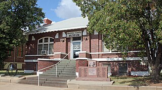
The Cordell Carnegie Public Library is a historic Carnegie library located at 105 E. First St. in New Cordell, Oklahoma. The library was built in 1911 through a $10,000 grant from the Carnegie foundation; New Cordell's Commercial Club, which had opened a reading room the previous year, solicited the grant. Architect A. A. Crowell designed the library in the Mission Revival style; several of its elements reflect the emerging Spanish Colonial Revival style. The building's curved parapet walls, exposed rafters, and original red tile roof are all characteristic Mission Revival elements; its segmental arches, sunburst moldings, and ornamental ironwork resemble Spanish Colonial Revival work. The library was the only one in Washita County until the 1960s; it also served as a community center and was regularly used by local schools. In 1982, a new library opened in New Cordell, and the Carnegie Library building became the Washita County Historical Museum.
Braithwaite is a ghost town in Washita County, Oklahoma, United States. Nothing currently remains there, besides a rail depot.


