Clinton, Oklahoma

Last updated

Clinton, Oklahoma
Motto: 
"Hub City of Western Oklahoma"
OKMap-doton-Clinton.PNG
Location of Clinton, Oklahoma
Coordinates: 35°30′24″N98°58′14″W / 35.50667°N 98.97056°W / 35.50667; -98.97056
Country United States
State Oklahoma
Counties Custer, Washita
Government
  TypeCouncil / Manager
Area
[1]
  Total9.97 sq mi (25.81 km2)
  Land9.95 sq mi (25.76 km2)
  Water0.02 sq mi (0.05 km2)
Elevation
[2]
1,568 ft (478 m)
Population
 (2020)
  Total8,521
  Density856.64/sq mi (330.75/km2)
Time zone UTC-6 (Central (CST))
  Summer (DST) UTC-5 (CDT)
ZIP code
73601
Area code 580
FIPS code 40-15400 [3]
GNIS feature ID2409485 [2]
Website clintonok.gov

Clinton is a city in Custer and Washita counties in the U.S. state of Oklahoma. The population was 8,521 at the time of the 2020 census. [4]

Contents

History

The community began in 1899 when two men, J.L. Avant and E.E. Blake, decided to locate a town in the Washita River Valley.

Because of governmental stipulations that an Indian could sell no more than one half of a 160-acre (0.6 km2) allotment, the men made plans to purchase 320 acres (1.3 km2) from four different Indians (Hays, Shoe-Boy, Nowahy, and Night Killer) and paid them each $2,000 for 80 acres (320,000 m2) to begin the small settlement of Washita Junction.

Congressional approval for the sale was granted in 1902 and Washita Junction quickly developed. [5] The first businesses were the office of the Custer County Chronicle newspaper and the First National Bank building. When a post office was started, the postal department would not accept the name of Washita Junction; so the town was named for Judge Clinton F. Irwin.

Clinton particularly benefited from the presence of U.S. Highway 66. Like most other cities and towns on Route 66, Clinton was home of tourist businesses including several restaurants, cafés, motels and filling stations. The Pop Hicks Restaurant was once the longest running restaurant on Route 66. It opened in 1936 and closed after a fire in 1999. The U.S. Highway 66 Association, founded 1927 in Tulsa, Oklahoma, curtailed its activity when World War II rationing of rubber and fuel disrupted leisure travel. After the war, Jack and Gladys Cutberth revived the organization in Clinton, where it promoted the "Main Street of America" from 1947 until it disbanded in the 1980s. [6] Dr. Walter S. Mason Jr. operated a Best Western motel (1964–2003) which welcomed Elvis Presley as an occasional guest in the 1960s. [7]

Today, cross-country traffic passes Clinton to the south on Interstate 40, which bypassed the city in 1970. [6] Clinton remains a popular tourist stop as one of the largest Route 66 cities between Oklahoma City and Amarillo, Texas. Much of the old U.S. 66 route that passed through the city is now designated as an I-40 business loop; the town became home to the first state sponsored Route 66 Museum in the nation. [8]

In 1942, the federal government built a naval airfield at nearby Burns Flat and named it Naval Air Station Clinton. During the World War II period, the population of Clinton grew to nearly 7,000 residents. In 1949, Naval Air Station Clinton was deactivated and the airfield was deeded to the City of Clinton, specifying that the land could be recaptured in case of national emergencies. Later, the government leased the site back and used it as Clinton-Sherman Air Force Base a bomber base supporting 4123rd Strategic Wing, then the 70th Bombardment Wing, Heavy of the Strategic Air Command (SAC), operating B-52 Stratofortress and KC-135 Stratotanker aircraft. Purchasing more land, the site soon expanded to more than 3,500 acres (14 km2), where both the U.S. Air Force and the U.S. Navy utilized the airfield for both operational and training purposes. When military operations were de-emphasized, the Clinton-Sherman base was designated for closure in 1969. The entire complex was deeded to the City of Clinton in 1971 and three years later became the Clinton-Sherman Industrial Airpark.

Clinton is also home to the Clinton Daily News, a six-day daily newspaper edited by Rod Serfoss which has a circulation of 4,500. [9] The newspaper has been published continuously from its inception in 1927 to the current day. [10]

Geography

Clinton is located on historic U.S. Route 66, which is now Interstate 40.

According to the United States Census Bureau, the city has a total area of 8.9 square miles (23.2 km2), of which 8.9 square miles (23.1 km2) is land and 0.04 square mile (0.1 km2) (0.22%) is water.

Climate

According to the Köppen Climate Classification system, Clinton has a humid subtropical climate, abbreviated "Cfa" on climate maps. The hottest temperature recorded in Clinton was 112 °F (44.4 °C) on July 19, 2022, while the coldest temperature recorded was −6 °F (−21.1 °C) on February 15, 2021. [11]

Climate data for Clinton, Oklahoma, 1991–2020 normals, extremes 1945–present
MonthJanFebMarAprMayJunJulAugSepOctNovDecYear
Record high °F (°C)83
(28)
91
(33)
94
(34)
99
(37)
106
(41)
110
(43)
112
(44)
111
(44)
108
(42)
100
(38)
92
(33)
79
(26)
112
(44)
Mean maximum °F (°C)72.9
(22.7)
76.4
(24.7)
83.4
(28.6)
89.0
(31.7)
96.4
(35.8)
101.4
(38.6)
105.1
(40.6)
104.3
(40.2)
98.5
(36.9)
90.6
(32.6)
79.5
(26.4)
71.3
(21.8)
105.2
(40.7)
Mean daily maximum °F (°C)51.1
(10.6)
55.2
(12.9)
64.7
(18.2)
73.8
(23.2)
81.8
(27.7)
90.6
(32.6)
95.2
(35.1)
94.3
(34.6)
86.4
(30.2)
74.8
(23.8)
61.4
(16.3)
51.2
(10.7)
73.4
(23.0)
Daily mean °F (°C)38.1
(3.4)
41.9
(5.5)
51.3
(10.7)
59.6
(15.3)
69.1
(20.6)
78.3
(25.7)
82.8
(28.2)
81.5
(27.5)
73.9
(23.3)
61.5
(16.4)
48.9
(9.4)
39.2
(4.0)
60.5
(15.8)
Mean daily minimum °F (°C)25.1
(−3.8)
28.7
(−1.8)
37.9
(3.3)
45.4
(7.4)
56.3
(13.5)
66.0
(18.9)
70.3
(21.3)
68.7
(20.4)
61.5
(16.4)
48.2
(9.0)
36.4
(2.4)
27.2
(−2.7)
47.6
(8.7)
Mean minimum °F (°C)11.9
(−11.2)
15.8
(−9.0)
21.6
(−5.8)
31.0
(−0.6)
42.7
(5.9)
56.6
(13.7)
62.4
(16.9)
61.1
(16.2)
49.6
(9.8)
32.8
(0.4)
21.9
(−5.6)
12.7
(−10.7)
7.0
(−13.9)
Record low °F (°C)−4
(−20)
−6
(−21)
1
(−17)
20
(−7)
26
(−3)
45
(7)
53
(12)
53
(12)
38
(3)
20
(−7)
11
(−12)
0
(−18)
−6
(−21)
Average precipitation inches (mm)0.92
(23)
1.23
(31)
2.68
(68)
2.63
(67)
3.76
(96)
3.63
(92)
2.51
(64)
4.16
(106)
3.98
(101)
2.28
(58)
1.77
(45)
1.46
(37)
31.01
(788)
Average snowfall inches (cm)2.6
(6.6)
2.0
(5.1)
0.5
(1.3)
0.0
(0.0)
0.0
(0.0)
0.0
(0.0)
0.0
(0.0)
0.0
(0.0)
0.0
(0.0)
trace0.4
(1.0)
1.7
(4.3)
7.2
(18.3)
Average precipitation days (≥ 0.01 in)4.75.46.05.78.28.25.45.96.56.25.64.772.5
Average snowy days (≥ 0.1 in)1.41.00.40.00.00.00.00.00.00.00.21.14.1
Source 1: NOAA (average snow/snow days 1981-2010) [12] [13]
Source 2: National Weather Service [11]

Demographics

Historical population
CensusPop.Note
1910 2,781
1920 2,596−6.7%
1930 7,512189.4%
1940 6,736−10.3%
1950 7,55512.2%
1960 9,61727.3%
1970 10,3597.7%
1980 9,730−6.1%
1990 9,248−5.0%
2000 8,833−4.5%
2010 9,0332.3%
2020 8,521−5.7%
U.S. Decennial Census [14]

As of the census [3] of 2015, The population density was 989.1 inhabitants per square mile (381.9/km2). There were 3,818 housing units at an average density of 427.5 per square mile (165.1/km2). The racial makeup of the city was 52.2% White, 3.2% African American, 3.4% Native American, 2.4% Asian, 0.07% Pacific Islander, 13.62% from other races, and 5.1% from two or more races. Hispanic or Latino of any race were 34.8% of the population.

There were 3,331 households, out of which 32.6% had children under the age of 18 living with them, 51.7% were married couples living together, 11.7% had a female householder with no husband present, and 32.0% were non-families. 28.5% of all households were made up of individuals, and 14.1% had someone living alone who was 65 years of age or older. The average household size was 2.55 and the average family size was 3.14.

In the city, the population was spread out, with 27.6% under the age of 18, 8.9% from 18 to 24, 25.7% from 25 to 44, 20.5% from 45 to 64, and 17.4% who were 65 years of age or older. The median age was 36 years. For every 100 females, there were 93.0 males. For every 100 females age 18 and over, there were 88.3 males.

The median income for a household in the city was $27,051, and the median income for a family was $32,242. Males had a median income of $24,588 versus $18,596 for females. The per capita income for the city was $14,606. About 14.6% of families and 18.9% of the population were below the poverty line, including 23.9% of those under age 18 and 11.1% of those age 65 or over.

Economy

Automotive manufacturer SportChassis, a maker of customized tow rigs, has its global headquarters in Clinton. [15]

Events

The Clinton Regional Airport was the site of the first crash of a C-5 Galaxy (68-0227) on September 27, 1974. [16]

Notable people

Education

Its school district is Clinton Public Schools. [18] [19]

Clinton has three elementary schools, one middle school and one high school within the public school system. There is also an alternative school that is part of the public school system.

Sports

Clinton is known for its high school football team, the "Red Tornadoes". The Red Tornadoes have won 17 state championships (1965, 1967, 1968, 1969, 1978, 1982, 1984, 1996, 1997, 2000, 2001, 2003, 2004, 2005, 2007, 2012, 2021) [20] which ranks currently second in the state of Oklahoma behind Ada. The Red Tornado football program currently ranks first in the state in all-time wins. Along with football, Clinton excels at a number of other sports. Other school sports include boys' and girls' basketball (the "Lady Red Tornadoes" or "Lady Reds"), baseball, girls' softball, wrestling, tennis, soccer, girls' volleyball, and track and field. Clinton's wrestling team earned its first trip to a dual state championship final in 2015; it would lose to longtime rival Tuttle Tigers. They returned to the dual state championship final in 2017 where they lost to Tuttle, again. The Lady Red Tornadoes soccer team won the State Championship in 2017 under the leadership of Coach Eugene Jefferson.

Team colors are maroon and gold and the school mascot is an anthropomorphic tornado named "Tony."

Clinton hosted Minor league baseball. The Clinton Bulldogs played as members of the Class D level Oklahoma State League in 1922 and 1923. [21] [22]

Sights

Museums

National Register of Historic Places

Related Research Articles

<span class="mw-page-title-main">Washita County, Oklahoma</span> County in Oklahoma, United States

Washita County is a county located in the U.S. state of Oklahoma. As of the 2020 census, the population was 10,924. Its county seat is New Cordell. The county seat was formerly located in Cloud Chief. The county was created in 1891.

<span class="mw-page-title-main">Roger Mills County, Oklahoma</span> County in Oklahoma, United States

Roger Mills County is a county located in the western part of the U.S. state of Oklahoma. As of the 2020 census, the population was 3,442, making it the fourth-least populous county in Oklahoma. Its county seat is Cheyenne. The county was created in 1891.

<span class="mw-page-title-main">Custer County, Oklahoma</span> County in Oklahoma, United States

Custer County is a county located in the U.S. state of Oklahoma. As of the 2020 census, the population was 28,513. Its county seat is Arapaho. The county was named in honor of General George Armstrong Custer.

<span class="mw-page-title-main">Canadian County, Oklahoma</span> County in Oklahoma, United States

Canadian County is a county located in the U.S. state of Oklahoma. As of the 2020 census, the population was 154,405, making it the fourth most populous county in Oklahoma. Its county seat is El Reno.

<span class="mw-page-title-main">Caddo County, Oklahoma</span> County in Oklahoma, United States

Caddo County is a county located in the U.S. state of Oklahoma. As of the 2020 census, the population was 26,945. Its county seat is Anadarko. Created in 1901 as part of Oklahoma Territory, the county is named for the Caddo tribe who were settled here on a reservation in the 1870s. Caddo County is immediately west of the seven-county Greater Oklahoma City metro area, and although is not officially in the metro area, it has many economic ties in this region.

<span class="mw-page-title-main">Beckham County, Oklahoma</span> County in Oklahoma, United States

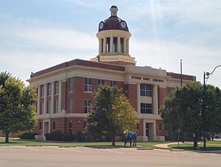
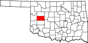
Beckham County is a county located on the western border of the U.S. state of Oklahoma. As of the 2020 census, the population was 22,410. Its county seat is Sayre. Founded upon statehood in 1907, Beckham County was named for J. C. W. Beckham, who was Governor of Kentucky and the first popularly elected member of the United States Senate from Kentucky. Beckham County comprises the Elk City, OK Micropolitan Statistical Area.

<span class="mw-page-title-main">Elk City, Oklahoma</span> City in Oklahoma, United States

Elk City is a city in Beckham County, Oklahoma, United States. The population was 11,561 at the time of the 2020 census, a slight decrease from the 11,693 figure of the 2010 census. Elk City is located on Interstate 40 and Historic U.S. Route 66 in western Oklahoma, approximately 110 miles (180 km) west of Oklahoma City and 150 miles (240 km) east of Amarillo, Texas.

<span class="mw-page-title-main">Arapaho, Oklahoma</span> Town in Oklahoma, United States

Arapaho is a town in, and the county seat of, Custer County, Oklahoma, United States. The population was 668 at the time of the 2020 census. The town lies long U.S. Route 183 and is named for the Arapaho Native American tribe.

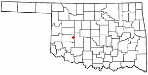
Custer City is a town in Custer County, Oklahoma, United States. Custer City is northeast of Clinton and northwest of Weatherford along Oklahoma 33. The population was 367 at the time of the 2020 census.

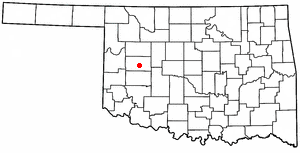
Weatherford is a city in Custer County, Oklahoma, United States. The population was 12,076 at the time of the 2020 census, a gain of about 11.5% over the 10,833 figure from the 2010 census.

<span class="mw-page-title-main">Wynnewood, Oklahoma</span> City in Oklahoma, United States

Wynnewood is a city in Garvin County, Oklahoma, United States. It is 67 miles (108 km) south of Oklahoma City. The population was 1,927 at the time of the 2020 census. Located in what was then the Chickasaw Nation of Indian Territory, it began as a village called "Walner" in 1886, on the proposed route of the Gulf, Colorado and Santa Fe Railway. Railroad workers from Pennsylvania named the community for Wynnewood, a community outside of Philadelphia. The name became official on April 6, 1887.

<span class="mw-page-title-main">Chandler, Oklahoma</span> City in Oklahoma, United States

Chandler is a city in, and the county seat of, Lincoln County, Oklahoma, United States. and is part of the Oklahoma City Metropolitan Area. The population was 2,858 at the time of the 2020 census. Chandler is located northeast of Oklahoma City on SH-66 and I-44, and north of Shawnee on SH-18.

<span class="mw-page-title-main">Sulphur, Oklahoma</span> City in Oklahoma, United States

Sulphur is a city in and county seat of Murray County, Oklahoma, United States. The population was 5,065 at the 2020 census, a 2.8 percent gain over the figure of 4,929 in 2010. The area around Sulphur has been noted for its mineral springs, since well before the city was founded late in the 19th century. The city received its name from the presence of sulfur in the water.

<span class="mw-page-title-main">Afton, Oklahoma</span> Town in Oklahoma, United States

Afton is a town in northeast Oklahoma in Ottawa County, Oklahoma, United States. The population was 734 at the time of the 2020 United States census.

<span class="mw-page-title-main">Cheyenne, Oklahoma</span> Town in Oklahoma, United States

Cheyenne is a town in Roger Mills County, Oklahoma, United States. As of the 2020 census, the town’s population was 771. It is the county seat of Roger Mills County.

<span class="mw-page-title-main">Strong City, Oklahoma</span> Town in Oklahoma, United States

Strong City is a town in Roger Mills County, Oklahoma, United States. As of the 2020 census, the town’s population was 33.

<span class="mw-page-title-main">Colony, Oklahoma</span> Town in Oklahoma, United States

Colony is a town in northeastern Washita County, Oklahoma, United States. The population was 136 at the 2010 U.S. census, a decrease of 7.5 percent from 147 in 2000. It was named for the Seger Colony, founded in 1886, which taught modern agricultural techniques to the Arapaho and Cheyenne tribes that would be resettled in the vicinity. Colony is 16 miles (26 km) east and 4 miles (6.4 km) north of Cordell.

<span class="mw-page-title-main">Corn, Oklahoma</span> Town in Oklahoma, United States

Corn is a town in Washita County, Oklahoma, United States. The population was 503 at the 2010 census.

<span class="mw-page-title-main">New Cordell, Oklahoma</span> City in Oklahoma, United States

New Cordell is a city in, and county seat of, Washita County, Oklahoma, United States. It lies along U.S. Route 183. The population was 2,915 at the 2010 census. The community was previously established a few miles from the current site, but was moved about 1900. It was named for a U.S. Postal Service employee in Washington D. C., Wayne W. Cordell. The official name is New Cordell, though it is now commonly called Cordell.

<span class="mw-page-title-main">Hammon, Oklahoma</span> Town in Oklahoma, United States

Hammon is a town in the U.S. state of Oklahoma, the majority of which is in Roger Mills County, but some of which extends into Custer County. It is located at the junction of Oklahoma State Highways 33 and 34.

References

  1. "ArcGIS REST Services Directory". United States Census Bureau. Retrieved September 20, 2022.
  2. 1 2 U.S. Geological Survey Geographic Names Information System: Clinton, Oklahoma
  3. 1 2 "U.S. Census website". United States Census Bureau . Retrieved January 31, 2008.
  4. "Clinton (city), Oklahoma". US Census Bureau. Retrieved October 16, 2023.
  5. Clinton at Encyclopedia of Oklahoma History and Culture Archived May 31, 2010, at the Wayback Machine (accessed April 27)
  6. 1 2 Sonderman, Jon; Ross, Jim (December 5, 2011). Route 66 in Oklahoma. Arcadia Publishing. p. 8. ISBN   9780738590516 . Retrieved August 20, 2012.
  7. "Old-style motels fading out". USA Today . December 3, 2003. Retrieved August 18, 2012.
  8. "Oklahoma Route 66 Museum". OKHistory.org. Clinton, Oklahoma: Oklahoma Historical Society.
  9. "Clinton Daily News". Finder Binder: Oklahoma's Updated Media Directory. Winter 2009.
  10. "About this Newspaper: Clinton Daily News". chroniclingamerica.loc.gov. Library of Congress . Retrieved February 25, 2010.
  11. 1 2 "NOAA Online Weather Data - NWS Norman". National Weather Service. Retrieved November 1, 2022.
  12. "U.S. Climate Normals Quick Access - Station: Clinton, OK (1991-2020)". National Oceanic and Atmospheric Administration. Retrieved on November 1 2022.
  13. "U.S. Climate Normals Quick Access - Station: Clinton, OK (1981-2010)". National Oceanic and Atmospheric Administration. Retrieved November 1, 2022.
  14. "Census of Population and Housing". Census.gov. Retrieved June 4, 2015.
  15. "Homepage". SportChassis. Retrieved April 2, 2020.
  16. "Lockheed C-5A Galaxy, 68-0227, 27 September 1974". okwreckchasing.org. Archived from the original on October 21, 2016. Retrieved June 20, 2018. Cites "Jumbo Jet Burns at Clinton". Daily Oklahoman . September 28, 1974.
  17. "WWII Army Enlistment Records".
  18. "2020 CENSUS - SCHOOL DISTRICT REFERENCE MAP: Custer County, OK" (PDF). U.S. Census Bureau . Retrieved February 10, 2024.
  19. "2020 CENSUS - SCHOOL DISTRICT REFERENCE MAP: Washita County, OK" (PDF). U.S. Census Bureau . Retrieved February 10, 2024.
  20. Godfrey, Ed (October 19, 2012). "High school football: Clinton honors 1967 team that was proclaimed high school national champions". NewsOK. Retrieved August 28, 2014.
  21. "1922 Oklahoma State League (OSL) Minor League Baseball on StatsCrew.com". www.statscrew.com.
  22. Johnson, Lloyd; Wolff, Miles, eds. (2007). The Encyclopedia of Minor League Baseball (Third ed.). Baseball America. ISBN   978-1932391176.
  23. "Oklahoma Route 66 Museum". City of Clinton. Retrieved April 2, 2020.
  24. "Cheyenne Cultural Center Inc". dexknows.com. Retrieved April 2, 2020.