
Mount Arvon at 1,979 feet (603 m), is the highest natural point in the U.S. state of Michigan. Located in L'Anse Township, Baraga County, Mount Arvon is part of the Huron Mountains. It rises about eight miles (13 km) south of Lake Superior. On the list of highest natural points in each U.S. state, Mount Arvon ranks 38th. It is the highest natural point in the East North Central states.

Loam is soil composed mostly of sand, silt, and a smaller amount of clay. By weight, its mineral composition is about 40–40–20% concentration of sand–silt–clay, respectively. These proportions can vary to a degree, however, and result in different types of loam soils: sandy loam, silty loam, clay loam, sandy clay loam, silty clay loam, and loam.

The following is an alphabetical list of articles related to the U.S. state of Kansas.
Soil texture is a classification instrument used both in the field and laboratory to determine soil classes based on their physical texture. Soil texture can be determined using qualitative methods such as texture by feel, and quantitative methods such as the hydrometer method based on Stokes' law. Soil texture has agricultural applications such as determining crop suitability and to predict the response of the soil to environmental and management conditions such as drought or calcium (lime) requirements. Soil texture focuses on the particles that are less than two millimeters in diameter which include sand, silt, and clay. The USDA soil taxonomy and WRB soil classification systems use 12 textural classes whereas the UK-ADAS system uses 11. These classifications are based on the percentages of sand, silt, and clay in the soil.
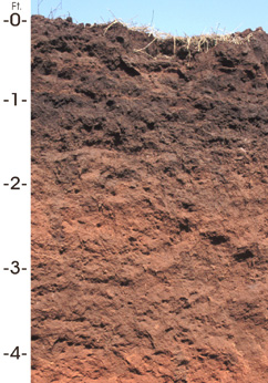
Port Silt Loam is the state soil of Oklahoma. This type of soil is reddish in color due to the weathering of reddish sandstones, siltstones, and shales of the Permian period.
The internment of Italian Americans refers to the US government's internment of Italian nationals during World War II. As was customary after Italy and the US were at war, they were classified as "enemy aliens" and some were detained by the Department of Justice under the Alien and Sedition Act. But in practice, the US applied detention only to Italian nationals, not to US citizens, or long-term US residents. Italian immigrants had been allowed to gain citizenship through the naturalization process during the years before the war, and by 1940 there were millions of US citizens who had been born in Italy.
Orovada series soil is the official state soil of Nevada. The soil series has an extent of 367,853 acres (148,865 ha), primarily in northern and central Nevada, and extending into southern Idaho and Oregon. They are common soils on semiarid rangeland with sagebrush-grassland plant communities. Orovada soils are arable, able to be cultivated, when irrigated and are considered prime farmland. Alfalfa for hay and seed, winter wheat, barley, and grasses for hay and pasture are the principal crops grown on these soils.

Aster alpinus, the alpine aster or blue alpine daisy, is a species of flowering plant in the family Asteraceae, native to the mountains of Europe, with a subspecies native to Canada and the United States. This herbaceous perennial has purple, pink, or blue flowers in summer.
Angora is an unincorporated community in Angora Township, Saint Louis County, Minnesota, United States.
In 1988, the Professional Soil Classifiers Association of Mississippi selected Natchez silt loam soil to represent the soil resources of the State. These soils exist on 171,559 acres of landscape in Mississippi.

Randolph is a rural unincorporated community in Tipton County, Tennessee, United States, located on the banks of the Mississippi River. Randolph was founded in the 1820s and in 1827, the Randolph post office was established. In the 1830s, the town became an early center of river commerce in West Tennessee. Randolph shipped more cotton annually than Memphis until 1840. In 1834, the first pastor of the Methodist congregation was appointed. The fortunes of the community began to decline in the late 1840s due to failed railroad development, an unfavorable mail route and other factors. The first Confederate States Army fort in Tennessee was built at Randolph early in the Civil War in 1861, a second fortification at Randolph was constructed later that same year. During the Civil War, the town was burned down twice by Union Army forces.
Waubeek is an unincorporated community in Linn County, Iowa, United States.
Whittier is an unincorporated community in Linn County, Iowa, United States. It is located at the intersections of County Roads X20 and E34 south of Waubeek and west of Viola, at 42.092976N, -91.462973W.
Arbor Hill is an unincorporated community or ghost town in Adair County, Iowa, United States.

Beech Bluff is an unincorporated community on the east-central edge of Madison County, Tennessee, United States. The area ZIP code is 38313.

Watering Run is a tributary of Big Wapwallopen Creek in Luzerne County, Pennsylvania, in the United States. It is approximately 4.2 miles (6.8 km) long and flows through Wright Township. The watershed of the stream has an area of 3.87 square miles (10.0 km2). Soils in the vicinity of the stream include Morris Silt Loam, Braceville and Chenango Gravelly Loams, Oquaga and Lordstown Silt Loams, and Rexford Loam. The stream is designated as a Coldwater Fishery. It flooded in 1972.
Hop Bottom Creek is a tributary of Martins Creek in Susquehanna County, Pennsylvania, in the United States. It is approximately 13.5 miles (21.7 km) long and flows through Bridgewater Township, New Milford Township, Brooklyn Township, Lathrop Township, and Hop Bottom. The watershed of the creek has an area of 15.6 square miles (40 km2). The creek is not designated as an impaired waterbody. It is a relatively small stream with a deep valley. In its upper reaches it is approximately 10 feet (3.0 m) wide. The surficial geology in the creek's vicinity mainly consists of Wisconsinan Till, alluvium, bedrock, and wetlands.
Oakland Mills is an unincorporated community in Henry County, Iowa, United States. The community is located along the Skunk River at the intersection of county highways W55 and H46, 3.8 miles (6.1 km) west-southwest of downtown Mount Pleasant.
Edler is an unincorporated community in Baca County, Colorado, United States.


