The Salmon River is located in Idaho in the northwestern United States. The Salmon is also known as "The River of No Return". It flows for 425 miles (685 km) through central Idaho, draining a rugged, thinly populated watershed of 14,000 square miles (36,000 km2) and dropping more than 7,000 feet (2,100 m) between its headwaters, near Galena Summit above the Sawtooth Valley in the Sawtooth National Recreation Area, and its confluence with the Snake River. Measured at White Bird, its average discharge is 11,060 cubic feet per second. It is one of the largest rivers in the continental United States without a single dam on its mainstem.

The Jarbidge River is a 51.8-mile-long (83.4 km), high elevation river in northern Nevada and southwest Idaho in the United States. The Jarbidge originates as two main forks in the Jarbidge Mountains of northeastern Nevada and then flows through basalt and rhyolite canyons on the high plateau of the Owyhee Desert before joining the Bruneau River.

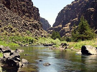
The Bruneau – Jarbidge Rivers Wilderness is located on the high basalt plateaus of Owyhee County in southwestern Idaho in the western United States. The wilderness area is named after and protects much of the Bruneau and Jarbidge Rivers and their canyons. Whitewater rafting is a popular recreational activity in this wilderness area, which has rivers up to Class V. About 40 miles (64 km) of the Bruneau River and about 28.8 miles (46.3 km) of the Jarbidge River are classified as a wild river.

The Pole Creek Wilderness is located on the high rhyolite and basalt plateaus of Owyhee County in southwestern Idaho in the western United States. Its whitewater rapids are a popular attraction.

The North Fork Owyhee Wilderness is on the high basalt plateaus of Owyhee County in southwestern Idaho in the western United States. The rivers within it offer whitewater rapids up to Class IV. The upper 20.8 miles (33.5 km) of the North Fork Owyhee River, from the Idaho–Oregon border to the upstream boundary of the wilderness, are part of the National Wild and Scenic Rivers System. Of this total, 15.1 miles (24.3 km) are classified as wild and the remaining 5.7 miles (9.2 km) are classified "recreational".

The Big Jacks Creek Wilderness is located on the high basalt plateaus of Owyhee County in southwestern Idaho in the western United States. Little Jacks Creek Wilderness is on its northwest border. About 35 miles (56 km) of Big Jacks Creek is classified as a wild river.

The Little Jacks Creek Wilderness is located on the high basalt plateaus of Owyhee County in southwestern Idaho in the western United States. Big Jacks Creek Wilderness is on its southeast border. About 12.4 miles (20.0 km) of Little Jacks Creek is classified as a wild river.

Willow Creek is a 84-mile (135 km) long tributary of the Snake River in the U.S. state of Idaho. Beginning at an elevation of 6,568 feet (2,002 m) east of the Blackfoot Mountains in southeastern Bingham County, it flows generally north into Bonneville County and past Bone. South of the town of Ririe, the creek is impounded by Ririe Dam, forming Ririe Reservoir. It then turns southwest, passing between Iona and Ucon, before bifurcating into two distributaries, North Fork Willow Creek and South Fork Willow Creek, at an elevation of 4,777 feet (1,456 m). Both forks reach the Snake River north of Idaho Falls.
Sailor Creek is a 64-mile (103 km) long tributary of the Snake River in the U.S. state of Idaho. Beginning at an elevation of 4,879 feet (1,487 m) southwest of Castleford in southeastern Owyhee County, it flows north through the Bruneau Desert, briefly crossing into Elmore County in the process. It then flows northwest to its mouth near Hammett, at an elevation of 2,467 feet (751.9 m).

Camas Creek is a 64-mile (103 km) long river in southern Idaho, United States, that is a tributary of the Big Wood River.

Sheep Creek is a 63-mile (101 km) long tributary of the Bruneau River. Beginning at an elevation of 6,126 feet (1,867 m) east of Owyhee in northern Elko County, Nevada, it flows generally north into Owyhee County, Idaho and the Owyhee Desert, where it is roughly paralleled by Idaho State Highway 51. It then flows to its mouth in the Bruneau – Jarbidge Rivers Wilderness, at an elevation of 3,415 feet (1,041 m). In 2009, 25.6 miles (41.2 km) of the creek were designated as wild by the Omnibus Public Land Management Act, which also created the Bruneau – Jarbidge Rivers Wilderness.
Squaw Creek is a 61-mile (98 km) long a river in western Idaho, United States, that is a tributary of the Payette River.

The Little Owyhee River is a 61-mile (98 km) long tributary of the South Fork Owyhee River. Beginning at an elevation of 6,739 feet (2,054 m) east of the Santa Rosa Range in eastern Humboldt County, Nevada, it flows generally east into Elko County, Nevada and the Owyhee Desert. From there, it flows north into Owyhee County, Idaho and reaches its mouth at an elevation of 4,363 feet (1,330 m).
Big Jacks Creek is a 58-mile (93 km) long tributary of Jacks Creek in Owyhee County, Idaho. Beginning at an elevation of 5,935 feet (1,809 m) north of Riddle, it flows generally north and slightly east through the arid Big Jacks Creek Wilderness, before reaching its mouth southwest of Bruneau, at an elevation of 2,779 feet (847.0 m). In 2009, 35.0 miles (56.3 km) of the creek were designated as wild by the Omnibus Public Land Management Act, which also created the Big Jacks Creek Wilderness.
Marsh Creek is a 56-mile (90 km) long tributary of the Portneuf River in Bannock County, Idaho. Beginning at an elevation of 5,157 feet (1,572 m) near Red Rock Pass, it flows generally north near the communities of Downey and Arimo. It parallels the Portneuf River starting near McCammon, reaching its mouth near Inkom, at an elevation of 4,518 feet (1,377 m). It is roughly paralleled by Interstate 15 for most of its length.
Blue Creek is a 53-mile (85 km) long tributary of the Owyhee River in the U.S. state of Idaho. Beginning at an elevation of 6,097 feet (1,858 m) in central Owyhee County, it flows generally south through the Owyhee Desert and near the community of Riddle, where it is roughly paralleled by Idaho State Highway 51. It then flows into the Duck Valley Indian Reservation to its mouth near the Idaho/Nevada border northwest of Owyhee, Nevada, at an elevation of 5,289 feet (1,612 m).
Jacks Creek is a 15-mile (24 km) long tributary of the Bruneau River in Owyhee County, Idaho. Beginning at the confluence of Big Jacks Creek and Little Jacks Creek at an elevation of 2,779 feet (847.0 m) southwest of Bruneau, it flows generally northeast to its mouth at C. J. Strike Reservoir, at an elevation of 2,457 feet (748.9 m). It was named after Jack Turner, a rancher who settled the area in 1869.

The North Fork Owyhee River is a tributary, about 30 miles (48 km) long, of the Owyhee River in Malheur County, Oregon, and Owyhee County, Idaho, in the United States. It begins on the east flank of the Owyhee Mountains in Idaho and flows generally southwest to meet the main stem at Three Forks, Oregon, 161 miles (259 km) above the confluence of the larger river with the Snake River.