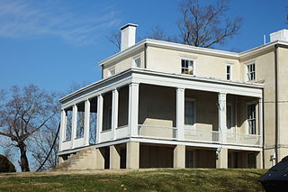
Clover Forest Plantation, located in Goochland, Virginia between Richmond and Charlottesville, is an authentically restored plantation on the upper James River, in the Piedmont. It has a Federal-stylemansion, with portions dating to pre-Revolutionary America; terraced landscaped grounds, and a private lake. The property lies in a large bend of the James River.
In 1714, the land on which Clover Forest stands was initially included within 2,000 acres (810ha) patented by Charles Fleming, extending along the upper James River from what were developed as Rock Castle to Elk Island plantations. Bolling Island was also developed along the river.[2] This territory was eventually divided and developed as the neighboring plantations of Rock Castle, Snowden, and Howard’s Neck, and the site of Elk Island. Because of the later colonial and antebellum history of this area, as well as several extant plantations, it has been proposed for designation as Fleming's Part Rural Historic District in a 2003 architectural survey prepared for the state's Department of Historic Resources.[2]
Fleming was unable to develop it rapidly enough, and portions "fell back" to the Crown of England. In 1739/1740 Lieutenant Governor William Gooch authorized the sale of 2,590 acres (1,050ha) for £13 to John Woodson, Gentleman. Woodson split the purchase with Joseph Dabbs, but Woodson and Dabbs failed "to make such cultivation and improvements" to the land as required, and the land reverted again to the Crown.
In 1745, the land was sold again, for £13 to Philip Webber. Webber could not fulfill his obligations for development and again the land reverted. It was resold, this time for £11 15/-, to Arthur Hopkins in 1753. Hopkins apparently accomplished more with the land; under his ownership only a portion reverted to the Crown.[3][4]
William Douglas (1761-1763)
On August 7, 1761, the Reverend William Douglas and his wife (née Nicholas) successfully patented 1,134 acres (459ha) for £4 10/-.[3][4] Their purchase of the property in 1761 has been considered the start of development of Clover Forest. Douglas and his wife may have occupied the house at Clover Forest as their residence, or used the farm to provide produce. They are credited with building what is today the oldest section of the house (the lower part of the west wing). Twenty months later when they sold the land, houses and orchards were conveyed with it.
Douglas is noted, at least locally, as author of the Douglas Register, an important resource for historians and genealogists. He was minister of the vast St. James Northam Parrish of the Church of England, the established church in the colony. It encompassed today's Virginia counties of Goochland, Fluvanna, Louisa, Orange, and Spotsylvania. The original Dover Church in Goochland, no longer standing, was his home church.
As the only legally authorized clergyman of the established church, Douglas compiled (nearly) all births, marriages, and deaths during the period from about 1750 to 1797. He also recreated some miscellaneous records dating to 1705, as no register was maintained before he was called to the parish.[5]
Bowler Cocke the younger of Henrico County (1763-1792)
On 19 April 1763, Bowler Cocke the younger of Henrico County became the new owner. He kept the property for almost thirty years. He did not appear to live in Goochland but operated the plantation for profit. At the close of the American Revolutionary War, Cocke refined his holding, selling a portion here and buying land there, resulting in a continuous holding of 898 acres (363ha).[6][7][8] Cocke was an active land speculator, owning many different tracts of land both within and outside Goochland County. Like other speculators, Cocke bought some of the lands in Kentucky and Ohio that had been granted in lieu of pay to Revolutionary war veterans. He may have encountered Captain Thomas Pemberton through such transactions.[4]
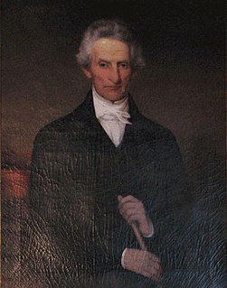
Captain Thomas Pemberton: (1792-1828)
Thomas Pemberton's origins are not known. Some evidence points to Buckingham County, but its courthouse burned twice (!), making research there very difficult. Some evidence points to King William County.[9]
Officer, Continental Dragoon and Legionnaire
Pemberton on Patrol by Sebastian Volcker, 2005, acrylic on canvas. Rendering of Captain Thomas Pemberton in the 1781 uniform he might have worn.
Pemberton was known to be commissioned as cornet in Bland's Virginia Horse, later the 1st Continental Light Dragoons, on December 5, 1776. (A cornet is the officer bearing the flag or regimental colors). Thirteen days later he was promoted to second lieutenant, and the regiment soon headed north to join General George Washington at Valley Forge. As the Continental Army had little cavalry, the Dragoons were called on for scouting, foraging, and warfare.
Pemberton made first lieutenant in 1778. He was promoted to captain in the 1st Regiment of Continental Light Dragoons on June 12, 1779, after the Regiment's transfer the previous year from the Main Continental Army to the Southern Department. All four regiments evolved from light dragoons units to legions that combined mounted and foot units. The 1st, 3rd and 4th eventually merged and fought together in one unit of four troops under the command of Colonel William Washington (cousin of the General), and officially named the 1st Legionary Corps on January 1, 1781. The First, as Dragoon and Legion, fought in Northern New Jersey, protected Philadelphia, survived the siege of Charleston 1780, fought with Lafayette in Virginia and at Yorktown, and defended the Carolinas in Nathaniel Greene's Campaign.[10]
Pemberton retired from military service on November 9, 1782 or January 1783.[11] For his six years of military service, Pemberton was awarded 4,000 acres (1,600ha) in Kentucky on the waters of the North Forke. He was one of the original members of the Society of the Cincinnati in the State of Virginia.[12]
B. Pembertons of Goochland
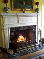
In 1792 (exact records have not survived) Captain Thomas Pemberton and his wife Dice acquired the plantation that they named Clover Forest. In 1795 they sold the 4,000 acres (1,600ha) of Kentucky bounty lands which Pemberton had been awarded for his service in the Continental Army to Bowler Cocke. In 1807 Pemberton had the main part of the house constructed. Over an English basement were built the parlor, the master bedchamber (today the dining room), two large rooms and an annex, and a large attic room under the rafters. On one of the chimneys is a brick dated 1811, marking the completion of the construction. All the wood work in the parlor, the hall and staircase e, and most of the dining room, dates to this period. Of particular interest are the mantles in the dining room and parlor. On one the seal of the United States commemorates Pemberton's service The eagle's head is turned to the olive branch. On the other, agricultural implements symbolize Pemberton's return to agricultural pursuits.
The seal of the United States on the surround of the dining room fireplace commemorates Captain Pemberton's service.
Detail of the Clover Forest mantel showing the Eagle of the United States, commemorating Pemberton's service in the Continental Army.
Detail of the Clover Forest mantel showing the agricultural implements symbolizing Captain Thomas Pemberton's return to agrarian life.
Anne Coleman Pemberton Crenshaw, said to be copy of a painting by Thomas Sully. Picture courtesy of Dave and Nancy Brown.
Three generations of Pembertons would live at Clover Forest, longer than any other family. Captain Thomas Pemberton and his wife Dice had six children who lived to adulthood, four daughters and two sons: Ann Coleman (married Ashburry Crenshaw, April 1810); Dice King (married Isaac Quarles, Jr., August 4, 1814); Mary B. (married Archibald Bryce, on January 16, 1811); and Maria A. (married John A. Selden, on August 24, 1823); John B. (married Mary Louisa Gilliam, daughter of John Gilliam, on February 7, 1829); and Robert (married Lucy Jane Scott, daughter of Thomas Scott, on May 1, 1828. [13][14]).
Captain Pemberton served as a church warden for the Lickinghole Episcopal Church, on Lickinghole Creek where he helped straighten out the property deed of the Church.[15] He represented the Cartersville Bridge Company in trying to mediate the conflict between the first Cartersville Bridge (chartered 1818, finished 1821) and Randolph Harrison's competing ferry. Harrison offered crossings at a lower toll rate.[16] The mediation was not successful, and the conflict reached the Virginia Supreme Court, long after Pemberton's passing.[17]
Pemberton died on October 4, 1828, a few months after having obtained a pension for his military service. As Dice Pemberton is not mentioned in her husband’s will, she likely died before her husband. They are both thought to be buried in the Pemberton family cemetery on the grounds of Clover Forest Plantation. Their graves did not have headstones but were visible at one time.[18]
Batteaux at Cartersville landing opposite Pemberton with the third and fourth Cartersville Bridge in the background.
Village of Pemberton
The village of Pemberton was named for the Pemberton family of Clover Forest Plantation. Now barely a hamlet overlooking the James River, it was once a hub of activity. Through the years, it was connected to trade by canal and river, and later railroad.
John B. and Mary Louisa Gilliam Pemberton: (1828-1873)
John B. Pemberton(b. May 13, 1803-d. Clover Forest Dec 9, 1848), eldest son of Captain Thomas Pemberton, married Mary Louisa Gilliam on February 7, 1829. His father died later that year. The couple had five known children, four of whom lived to adulthood: Polly, Thomas, Virginia, and Richard.
Mary Louisa Gilliam Pemberton was the last of the Pembertons to live at Clover Forest. Born Dec. 6, 1803, she died in September 1873 at age 69. The Pembertons had occupied the property for 81 years. She is buried in the Pemberton family cemetery on the grounds of Clover Forest Plantation, near her son John (b. March 5, 1835 - d. Christmas Day 1839) and her husband.[19]
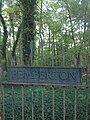
Pemberton Cemetery Gate
Sacred, to the memory of, John B. Pemberton, eldest son of, Capt. Thomas Pemberton, of Goochland, Born May 13, 1803, Died at Clover Forest, Dec. 9th 1848.
John 4 years old died Christmas Day: Sacred to the memory of, John, son of, John B. and Mary L., Pemberton, Born March 5, 1835, Died Dec., 25 1839.
Mary Louisa Gilliam, Wife of, John B. Pemberton, Born Dec. 6, 1803, Died Sept. 15, 1873.
Parrish through Witcamp (1884-1949)
Due to debt, creditors of the Pembertons won a Chancery suit in 1870. John Colton bought Clover Forest that year, but apparently allowed Mary Louise Gilliam Pemberton to live at the property until her death a few years later. Colton defaulted on his payments, and in 1879 a decree for resale was imposed.
In 1881 William H. Parrish bought Clover Forest, then comprising more than 900 acres (360ha) that then comprised Clover Forest, and it was legally conveyed to him in 1884. In 1882, Parrish bought an additional 790.5 acres (319.9ha) of Howard's Neck Plantation, which bordered on Clover Forest, to enlarge his holding.[18][20][21]
Two brothers Boggs, hailing from West Virginia with family money from coal and oil, bought the adjoining properties of Clover Forest and Snowden. There were intermarriages with the Pearcys and Witcamps.
Richard S. and Margarite Louise Holson (1949-1967)
Richard S. and Louise Holson, as she was known, were a couple from Chicago who purchased Clover Forest to use both as a vacation home and as a working farm; it was run as a business, Independence Operations, Inc. In 1962 they acquired the low grounds of Bolling Island to add to their property.[22]
The Holsons brought many furnishings from Chicago, such as the kitchen cabinets and an old gas crystal chandelier that still hangs in the dining room. Farm manager, Bud Engel, also from Illinois, was entrusted with both the large modern cattle and hog operation and physical upgrades to Clover Forest. Most of the outbuildings and former slave quarters were likely removed in this period. A three-car carriage house replaced the outhouse. The east side porch and root cellar were removed, and the library wing was added to the house. The bedrooms were equipped with bathrooms.
The existing terraces were augmented. A dam was built across the creek, forming a 7-acre lake. The dam had to be made higher than originally intended as an additional spring was uncovered near the dam site. A three-hole golf course and Mrs. Holson's rose garden were laid out and tended by three full-time gardeners. Pickett Pannel (sp?) was the head gardener. He also served as the undertaker for the black community. Buddy Cave was chiefly in charge of the maintenance of golf course.[citation needed]
When the Holsons sold their property, Bud Engel remained in Virginia. He had a farm of his own in King William County, which he worked with his son Kevin.[23] Kevin Engel has also stayed in farming, adapting modern technology. He founded Engel Family Farms in 1991. In 2009 his business had 23 employees who worked 14,000 acres (5,700ha) in many areas of Virginia; all but 500 acres (200ha) are now owned by other people. He has specialized in grains: corn, wheat and barley, and soybeans. Engel rents land from a total of 86 owners.[23] Some of their land was once part of Independence Operations, Inc. at Clover Forest.
Floyd Dewey Gottwald, Sr. (1967-197?)
Swine or pig board used to handle hogs at fairs and display the owner's name.
Floyd Dewey Gottwald, Sr. was the Chairman of Ethyl Corporation of Richmond when he bought Clover Forest and the nearby plantation of Snowden from Fred and Virginia Fleischman. He traded Contention Plantation, located further east in Goochland County, for Snowden.[24] Together the two plantations were operated under the business name of Snowden Corporation.
He hired Robert Lee Johnson (February 13, 1920- August 1979) as the Farm Manager and Steve Lawson Sr. as the Swine Manager. Before working for Snowden Corporation, Johnson had been farm manager for the Snead Dairy Farm (it is known today as Willow Oaks); he had been in farming since childhood.[25][when?]
Gottwald was enthusiastic about learning the history of the plantations. When William E. Trout III told him about the "Cartersville Connection", the short canal and lock that connected the Kanawha Canal to the James River and the Cartersville port, Gottwald had the Connection excavated. It was found to be in nearly perfect condition.[26]
Gottwald created a 67-acre lake off Whittcamp Road by damming Pickett's Creek, also known as Fleming's Park Creek. There had been a mill on the creek at one time. Joe Scales was hired to conduct engineering of the dam; it was the largest private lake project in Goochland.
The Gottwalds sold the properties under the Snowden Corporation in the 1970s. A land speculator bought them and worked to divide and develop the properties.
Clover Forest today (1978-present)
Johnson was farm manager until his death in 1979. He was succeeded by Jimmy W. Jones, who worked until 2001. The Clover Forest Plantation continues to be operated as a working farm. It now has a flock of sheep and tenant cattle. Much of the property distant from the mansion was sold to new owners. Some depend on cultivation and management by Engels Family Farm.
Since 2003, the Clover Forest Mansion and its immediate grounds operates as a bed and breakfast and special events venue. It added Clover Forest Catering in 2004.
Bibliography
Bullard, CeCe (1994). Goochland Yesterday and Today. Goochland County Historical Society.
Farrar, Emmie Fergusson; Hines, Emilee (1974). Old Virginia Houses, The Heart of Virginia. Hale Publishing.
Hudgins, Dennis (1996). "Goochland County Plat Number Index to the Surveys in the Virginia Land Office Patent and Grant Books". Goochland County Historical Society Magazine. XXVIII.
Loescher, Burt Garfield (March 1954). Bland’s Virginia Horse: The Story of the First Continental Light Dragoons. Journal of the Company of Military Collectors & Historians, Vol. VI, No. 1.
Miner, Robert G. (1977). Survey of Early American Design. Arno Press Inc.
Trout, III, William E. (1994). The Slate and Willis's Rivers Atlas. The Virginia Canals & Navigations Society, Incorporated.
Weeks, Elie (1973). "Clover Forest". Goochland County Historical Society Magazine. B-1.
Wright Jr, Robert K. (1983). The Continental Army. Center of Military History, United States Army.
Related Research Articles
Goochland County is a county located in the Commonwealth of Virginia. Its southern border is formed by the James River. As of the 2010 census, the population was 21,717. Its county seat is Goochland.
Sandy Spring is an unincorporated community in Montgomery County, Maryland, United States.
The Appomattox Court House is a National Historical Park of original and reconstructed 19th century buildings in Appomattox County, Virginia. The village is famous as the site of the Battle of Appomattox Court House and containing the house of Wilmer McLean, where the surrender of the Confederate army under Robert E. Lee to Union commander Ulysses S. Grant took place on April 9, 1865, effectively ending the American Civil War. The McLean House was the site of the surrender conference, but the village itself is named for the presence nearby of what is now preserved as the Old Appomattox Court House.
Poplar Forest is a plantation and plantation house in Forest, Bedford County, Virginia. Thomas Jefferson designed the plantation and used the property as a private retreat and a revenue-generating plantation. Jefferson inherited the property in 1773 and began designing and working on the plantation in 1806. While Jefferson is the most famous individual associated with the property, it had several owners before being purchased for restoration, preservation, and exhibition in 1984.
Bremo Bluff is an unincorporated community located on the northern bank of the James River in Fluvanna County, Virginia, United States. The locale was established by the Cocke family in 1636. During the American Civil War, the family of General Robert E. Lee sought refuge in the community. It is home to Bremo Power Station, which generates 3 percent of the total electricity delivered by utility company Dominion Resources.
Manakin-Sabot, consisting of the villages of Manakin and Sabot, is an unincorporated community in Goochland County, Virginia, United States. It is located northwest of Richmond in the Piedmont and is part of the Greater Richmond region.
The Levi Jordan Plantation is located on Farm to Market Road 521, 4 miles (6.4 km) southwest of the city of Brazoria, in the county of Brazoria, in the U.S. state of Texas. It was one of the largest sugar and cotton producing plantations in Texas during the mid-19th century. It was designated a Recorded Texas Historic Landmark in 1967.
The Varner–Hogg Plantation State Historic Site is a historic site operated by the Texas Historical Commission. The site was the home of former Governor of Texas James S. Hogg and his family. The site is located outside West Columbia, in Brazoria County.
Bremo, also known as Bremo Plantation or Bremo Historic District, is a plantation estate covering over 1,500 acres (610 ha) on the west side of Bremo Bluff in Fluvanna County, Virginia. The plantation includes three separate estates, all created in the 19th century by the planter, soldier, and reformer John Hartwell Cocke on his family's 1725 land grant. The large neo-palladian mansion at "Upper" Bremo was designed by Cocke in consultation with John Neilson, a master joiner for Thomas Jefferson's Monticello. The Historic District also includes two smaller residences known as Lower Bremo and Bremo Recess.
Philip St. George Cocke was a brigadier general in the Confederate States Army during the first year of the American Civil War. He is best known for organizing the defense of Virginia along the Potomac River soon after the state's secession from the Union. He commanded troops in the Battle of Blackburn's Ford and the First Battle of Bull Run in July 1861 before becoming despondent and committing suicide.
The William Boggs Farm is located in the Back Creek Valley of Berkeley County, West Virginia ner Hedgesville. The property was settled before 1750 by William Boggs, who may have been the first settler in the valley. A 1750 survey indicates that Boggs had 275 acres (111 ha) of land with a cabin. By 1766 Boggs had accumulated 527 acres (213 ha). Boggs grew cash crops in the fertile bottomlands along Back Creek and raised clover for pasturage on the hilltops.
John Hartwell Cocke II was an American military officer, planter and businessman. During the War of 1812, Cocke was a brigadier general of the Virginia militia.
Richard Cocke (1597–1665) was a prominent colonial Virginia planter and politician. He established a political and social dynasty that firmly seated itself as among the most prominent in Virginia. Among his more prominent descendants are General Robert E. Lee and U.S. presidents George Washington, Thomas Jefferson, George H. W. Bush, and George W. Bush.
John Harding (1777-1867) was an American Southern planter and thoroughbred breeder in Middle Tennessee, near Nashville. He developed Belle Meade Plantation from 250 acres to 1300 in Davidson County; Bellevue at McSpadden's Bend on the Cumberland River, also in the county; and a 10,000-acre cotton plantation at Plum Point Bend in Mississippi County, Arkansas.
Pemberton is an unincorporated community in Goochland County, Virginia, United States. Virginia State Route 45 passes by Pemberton, located about 11 miles (18 km) west of Goochland, the county seat. It was named for the family that owned Clover Forest Plantation. Nearby is Howard's Neck Plantation, listed on the National Register of Historic Places.
Elk Hill, also known as Harrison's Elk Hill, is a historic plantation home located near Goochland, Goochland County, Virginia. It was built between 1835 and 1839, and is a 2 1/2-story, three-bay, stuccoed brick central-hall-plan house in the Greek Revival style. It has a two-story rear ell. The front facade features a one-story Tuscan order portico consisting of paired rectangular wooden pillars supporting a full entablature. Also on the property are the contributing servants' quarters, tack house, and spring house. It was listed on the National Register of Historic Places in 1979.
Black Walnut is a historic plantation house and farm located near Clover, Halifax County, Virginia. The main house was built in at least three sections beginning about 1774 to 1790. In the 1840s and 1850s, a substantial two-story frame addition was built in two stages parallel to the existing house, along with a connecting hyphen, together giving the house an overall "H"-shape. The interior features Greek Revival style details.
The Swann's Point Plantation Site is an archaeological site near the James River in Surry County, Virginia. The Swann's Point area, located west of the mouth of Gray Creek, has a rich historic of precolonial Native American occupation, as well as significant early colonial settlements. It was first granted to Richard Pace, whose warning famously saved the Jamestown Colony during the Indian Massacre of 1622. The Paces abandoned their settlement in 1624.
Elk Island, located in Goochland County, Virginia near Cartersville, is an island on the James River and across from the former Elk Hill plantation at the mouth of Byrd Creek. The island, one mile by five miles, is accessed by Elk Island Road.
References
↑ CeCe Bullard, Goochland Yesterday and Today, Goochland County Historical Society, 1994, pp. 113-137
1 2 Land Patent Book 33, p. 1107 (Virginia State Library)
1 2 3 Elie Weeks, "Clover Forest", Goochland County Historical Society Magazine, 5-A, 1973 p. 7.
↑ William Douglas, William MacFarlane Jones: The Douglas Register: Being a Detailed Record of Births, Marriages, and Deaths, Together with Other Interesting Notes, as Kept by the Rev. William Douglas from 1750 to 1797; an Index of Goochland Wills; Notes on the French-Huguenot Refugees who Lived in Manakin-town, Genealogical Publishing Company, 1966
↑ Elie Weeks, "Clover Forest" Goochland County Historical Society Magazine 5-A, 1973 p. 7.
↑ Elie Weeks, "Clover Forest", Goochland County Historical Society Magazine, B-1, 1973, p. 9.
↑ Burt Garfield Loescher: "Bland's Virginia Horse: The Story of the First Continental Light Dragoons", in Journal of the Company of Military Collectors & Historians, Washington D.C., March 1954, vol VI no 1 pp 1-6.
↑ Burt Garfield Loescher, Washington's Eyes: The Continental Light Dragoons, Old Army Press, 1977, p. 123.
↑ John Cropper, List of Original Members of the Society of the Cincinnati in the State of Virginia (1896)
↑ Ancestry.com. Virginia, Compiled Marriages, 1740-1850 [database on-line]. Provo, UT, USA: Ancestry.com Operations Inc, 1999. Original data: Dodd, Jordan R., et al.. Early American Marriages: Virginia to 1850. Bountiful, UT, USA: Precision Indexing Publishers.
↑ Helène Barret Agee, Facets of Goochland (Virginia) County's History, The Dietz Press, Incorporated, Richmond Virginia, 1962, p. 120.
↑ William E. Trout, III, The Slate and Willis's Rivers Atlas, The Virginia Canals & Navigations Society, Incorporated, 1994 p. 42
↑ Cases Decided in the Supreme Court of Appeals of Virginia, Volume 38, 1841, pp. 544-555
1 2 Elie Weeks, "Clover Forest" Goochland County Historical Society Magazine 5-A, 1973 p. 13.
↑ Elie Weeks, "Clover Forest", in Goochland County Historical Society Magazine 5-A, 1973 p. 10.
This page is based on this Wikipedia article Text is available under the CC BY-SA 4.0 license; additional terms may apply. Images, videos and audio are available under their respective licenses.