The Kingsport–Bristol–Bristol, Tennessee-Virginia Metropolitan Statistical Area is a Metropolitan Statistical Area (MSA) in Northeast Tennessee and Southwest Virginia as defined by the United States Office of Management and Budget (OMB). It was formed in December 2003 by the merger of the Bristol, VA MSA and Kingsport-Bristol, TN-VA MSA.

The Longview–Marshall Combined Statistical Area covers four counties in Northeast Texas. The statistical area consists of the Longview Metropolitan Statistical Area and the Marshall Micropolitan Statistical Area. Prior to 2003, the area was known as the Longview–Marshall Metropolitan Statistical Area, which consisted of Gregg, Harrison, Rusk, and Upshur counties. As of the 2000 census, the CSA had a population of 256,152.

The Lima–Van Wert–Wapakoneta Combined Statistical Area (CSA) is made up of three counties in Northwest Ohio. The Lima Metropolitan Statistical Area and two Micropolitan Statistical Areas – Van Wert and Wapakoneta, are components of the CSA. As of the 2000 Census, the CSA had a population of 184,743.

The Harrisburg–Carlisle, Pennsylvania, metropolitan statistical area is defined by the United States Census Bureau as an area consisting of three counties in Pennsylvania's Susquehanna Valley, anchored by the cities of Harrisburg and Carlisle. As of the 2010 census, the metropolitan statistical area (MSA) had a population of 549,475. In 2009, Harrisburg–Carlisle was the 96th largest metropolitan area in the United States. As of 2010, it is part of the defined Harrisburg–York–Lebanon, PA Combined Statistical Area, which includes York and Adams counties and has a population of 1,233,708 people making it the 43rd most populous in the United States.
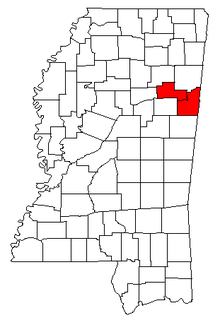
The Columbus-West Point, MS Combined Statistical Area was formerly defined as consisting of Clay and Lowndes counties in northeastern Mississippi, which were separately treated as the West Point Micropolitan Statistical Area and Columbus Micropolitan Statistical Area, respectively. As of the 2000 census, the CSA had a population of 83,565. A July 1, 2009 estimate placed the population at 80,380.

The Tyler–Jacksonville combined statistical area is made up of two counties in East Texas. The statistical area consists of the Tyler metropolitan statistical area and the Jacksonville micropolitan statistical area. As of the 2000 census, the CSA had a population of 221,365.

The Rockford Metropolitan Statistical Area, as defined by the United States Census Bureau, is an area consisting of four counties in north-central Illinois, anchored by the city of Rockford. As of the 2010 census, the MSA had a population of 349,431. The Rockford MSA is adjacent to the Janesville-Beloit MSA and the Chicago MSA. It forms the main part of the larger Rockford–Freeport–Rochelle Combined Statistical Area.

The Idaho Falls Metropolitan Statistical Area, as defined by the United States Census Bureau, is an area consisting of two counties in eastern Idaho, anchored by the city of Idaho Falls. As of the 2010 census, the MSA had a population of 130,374.
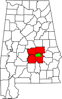
The Montgomery, Alabama Metropolitan Statistical Area is a metropolitan statistical area in central Alabama. As of 2010, the MSA had a population of 374,536, ranking it 136th among United States metropolitan areas.
The Paducah, KY-IL Micropolitan Statistical Area, as defined by the United States Census Bureau, is an area consisting of four counties – two in the Jackson Purchase region of Kentucky, a third Kentucky county bordering the Purchase, and one in southern Illinois – anchored by the city of Paducah, Kentucky.

The Muscatine Micropolitan Statistical Area, as defined by the United States Census Bureau, is an area consisting of two counties in east central Iowa, anchored by the city of Muscatine. The Muscatine Micropolitan Statistical Area is also a part of the Davenport-Moline, IA-IL Combined Statistical Area (CSA), which has a population of 474,226, making it the 90th-largest CSA in the nation.

The DeRidder-Fort Polk South, LA combined statistical area is made up of two parishes in central Louisiana. The statistical area consists of the Fort Polk South Micropolitan Statistical Area and the DeRidder Micropolitan Statistical Area. As of the 2000 census, the CSA had a population of 85,517.

The Reno–Sparks Metropolitan Statistical Area, as defined by the United States Census Bureau, is an area consisting of two counties in Western Nevada, anchored by the cities of Reno and Sparks. As of the 2010 census, the MSA had a population of 425,417.
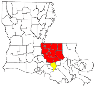
The Baton Rouge–Pierre Part Combined Statistical Area is a former Combined Statistical Area made up of ten parishes in southeastern Louisiana. The statistical area consisted of the Baton Rouge Metropolitan Statistical Area (MSA) and the Pierre Part Micropolitan Statistical Area (μSA). As of the 2000 census, the CSA had a population of 729,361. The Combined Statistical Area ceased to exist when the Pierre Part Micropolitan Statistical Area was eliminated by the Census Bureau.

The Madison, WI Metropolitan Statistical Area, as defined by the United States Office of Management and Budget, is an area consisting of Columbia, Dane, Green, Rock, and Iowa counties in Wisconsin, anchored by the city of Madison. As of the 2010 census, the MSA had a population of 605,435. The latest Census estimate as of July 1, 2017 puts the population at 654,230. The Madison–Janesville–Beloit Combined Statistical Area (CSA) had a population estimate of 880,520.
The Macon metropolitan area is a metropolitan area consisting of five counties in Central Georgia anchored by the principal city of Macon. The Office of Management and Budget defines the area as one of its metropolitan statistical areas, a designation used for statistical purposes by the United States Census Bureau and other agencies.
The Lafayette, Indiana Metropolitan Statistical Area, as defined by the United States Census Bureau, is an area consisting of three counties in Indiana, anchored by the city of Lafayette. As of the 2010 census, the MSA had a population of 235,013.
The Kokomo Metropolitan Statistical Area, as defined by the United States Census Bureau, is an area consisting of Howard county in Indiana, anchored by the city of Kokomo. As of the 2000 census, the MSA had a population of 101,541. The official 2013 population estimate for the metro area is 82,760 people are in the Kokomo metropolitan area. The MSA formerly included Tipton County, Indiana. Kokomo is also the principal city of the area known as North Central Indiana, the area around Kokomo with economic ties. The six county area including Cass, Clinton, Fulton, Howard, Miami, and Tipton counties had population of 228,331 people in 2010.

The London, Kentucky micropolitan area is made up of three counties in the Eastern Coalfield region of Kentucky. Before 2013, the area was officially known as the Corbin-London, KY Combined Statistical Area, and consisted of the Corbin Micropolitan Statistical Area and the London Micropolitan Statistical Area. The Corbin micropolitan area consisted of Whitley County, and the London micropolitan area consisted of Laurel County.