The Louisville metropolitan area is the 43rd largest metropolitan statistical area (MSA) in the United States. It had a population of 1,395,855 in 2020 according to the latest official census, and its principal city is Louisville, Kentucky.
United States micropolitan statistical areas, as defined by the Office of Management and Budget (OMB), are labor market and statistical areas in the United States centered on an urban cluster with a population of at least 10,000 but fewer than 50,000 people. The micropolitan area designation was created in 2003. Like the better-known metropolitan statistical areas, a micropolitan area is a geographic entity used for statistical purposes based on counties and county equivalents. The OMB has identified 543 micropolitan areas in the United States.
Pennsylvania has fourteen metropolitan statistical areas (MSAs) and four combined statistical areas (CSAs), as defined by the United States Census Bureau. A map of the Pennsylvania MSAs is available from the Census Bureau. As of 2020 Philadelphia is the seventh-largest United States metropolitan area.

The Lexington–Fayette metropolitan area is the 109th-largest metropolitan statistical area (MSA) in the United States. It was originally formed by the United States Census Bureau in 1950 and consisted solely of Fayette County until 1980 when surrounding counties saw increases in their population densities and the number of their residents employed within Lexington–Fayette, which led to them meeting Census criteria to be added to the MSA.

The Fort Morgan Micropolitan Statistical Area is a United States Census Bureau defined Micropolitan Statistical Area located in the Fort Morgan area of the State of Colorado. The Fort Morgan Micropolitan Statistical Area is defined as Morgan County, Colorado. The Micropolitan Statistical Area had a population of 27,171 at the 2000 Census. A July 1, 2009 U.S. Census Bureau estimate placed the population at 27,850.

The Silverthorne Micropolitan Statistical Area is a United States Census Bureau defined Micropolitan Statistical Area located in the Silverthorne area of the State of Colorado. The Silverthorne Micropolitan Statistical Area is defined as Summit County, Colorado. The Micropolitan Statistical Area had a population of 23,548 at the 2000 Census. A July 1, 2009 U.S. Census Bureau estimate placed the population at 27,239.

The Sterling Micropolitan Statistical Area is a United States Census Bureau defined Micropolitan Statistical Area located in the Sterling area of the State of Colorado. The Sterling Micropolitan Statistical Area is defined as Logan County, Colorado. The Micropolitan Statistical Area had a population of 20,504 at the 2000 Census. A July 1, 2009 U.S. Census Bureau estimate placed the population at 20,772.
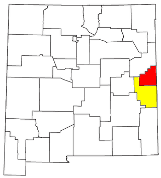
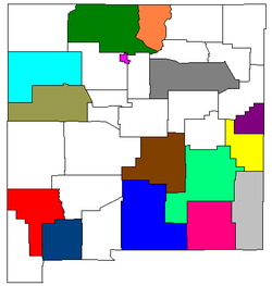
The Clovis-Portales Combined Statistical Area is made up of two counties in east central New Mexico. The statistical area consists of the Clovis Micropolitan Statistical Area and the Portales Micropolitan Statistical Area. As of the 2000 census, the CSA had a population of 63,062.

The Knoxville metropolitan area, commonly known as Greater Knoxville, is a metropolitan statistical area (MSA) centered on Knoxville, Tennessee, the third largest city in Tennessee and the largest city in East Tennessee. It is the third largest metropolitan area in Tennessee. In 2020, the Knoxville metro area had a population of 879,773. The Knoxville–Morristown–Sevierville Combined Statistical Area (CSA) had a population of 1,156,861 according to the census bureau in 2020.
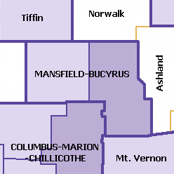
The Mansfield–Bucyrus, OH Combined Statistical Area is a CSA in the U.S. state of Ohio, as defined by the United States Census Bureau. It consists of the Mansfield Metropolitan Statistical Area ; and the Bucyrus Micropolitan Statistical Area. As of the 2000 Census, the Combined Statistical Area had a population of 175,818, but according to a US Census 2009 estimate, the CSA has a population of 167,893 residents.
The Salisbury, MD-DE Metropolitan Statistical Area is a United States Census Bureau-designated metropolitan area centered in and around Salisbury, Maryland, including four counties: Somerset, Wicomico, and Worcester in Maryland; and Sussex in Delaware.
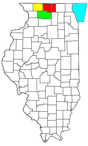
The Rockford Metropolitan Statistical Area, as defined by the United States Census Bureau, is an area consisting of four counties in north-central Illinois, anchored by the city of Rockford. As of the 2010 census, the MSA had a population of 349,431. The Rockford MSA abuts the southern portions of the Janesville-Beloit MSA and the Chicago MSA. It forms the main part of the larger Rockford–Freeport–Rochelle Combined Statistical Area.

The city of Portland, Maine, is the hub city of a metropolitan area in southern Maine, United States. The region is commonly known as Greater Portland or the Portland metropolitan area. For statistical purposes, the U.S. federal government defines three different representations of the Portland metropolitan area. The Portland–South Portland–Biddeford, Maine, metropolitan statistical area is a region consisting of three counties in Maine, anchored by the city of Portland and the smaller cities of South Portland and Biddeford. As of the 2010 census, the MSA had a population of 514,098. A larger combined statistical area (CSA), the Portland–Lewiston–South Portland combined statistical area, is defined as the combination of this metropolitan statistical area (MSA) with the adjacent Lewiston–Auburn MSA. The CSA comprises four counties in southern Maine. The Portland–South Portland metropolitan New England city and town area is defined on the basis of cities and towns rather than entire counties. It consists of most of Cumberland and York counties plus the town of Durham in Androscoggin County. The Greater Portland area has emerged as an important center for the creative economy, which is also bringing gentrification.

The Montgomery, Alabama Metropolitan Statistical Area is a metropolitan area in central Alabama. As of 2020, the MSA had a population of 386,047, ranking it 142nd among United States Metropolitan Statistical Areas. That number is up +3.07% from the 2010 census number of 374,536. In September of 2018 the OMB formed the Montgomery-Selma-Alexander City CSA. It's made up of the 4 county Montgomery MSA and the Selma, AL and Alexander City, AL micropolitan areas. The 7 county CSA has a population of 522,873 as of the 2020 census.
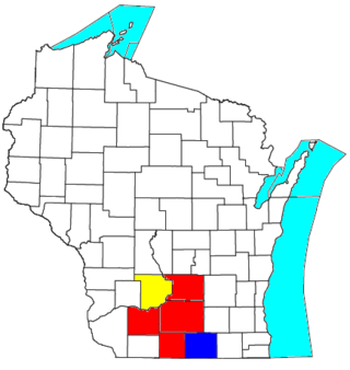
The Madison, Wisconsin, metropolitan area, also known as Greater Madison, is the metropolitan area surrounding the city of Madison, Wisconsin. Madison is the state capital of Wisconsin and is Wisconsin's second largest city, and the metropolitan area is also the state's second largest.

The Ponce Metropolitan Statistical Area is a United States Census Bureau defined Metropolitan Statistical Area (MSA) in south central Puerto Rico. A 1 July 2009 Census Bureau estimate placed the population at 262,414, a 0.95% decrease from the 2000 census figure of 264,919.
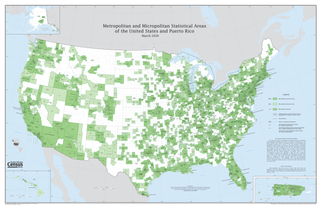
The United States federal government defines and delineates the nation's metropolitan areas for statistical purposes, using a set of standard statistical area definitions. As of 2020, the U.S. Office of Management and Budget (OMB) defined and delineated 392 metropolitan statistical areas (MSAs) and 547 micropolitan statistical areas (μSAs) in the United States and Puerto Rico. Many of these 939 MSAs and μSAs are, in turn, components of larger combined statistical areas (CSAs) consisting of adjacent MSAs and μSAs that are linked by commuting ties; as of 2020, 551 metropolitan and micropolitan areas are components of the 175 defined CSAs. A collective term for MSAs, μSAs, and CSAs is primary statistical areas (PSAs), though that term is not used by OMB.