Melrose, New Mexico

Last updated

Melrose
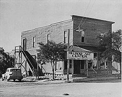
Melrose, New Mexico Art Center.jpg
Melrose Art Center in ca. 1935. It was run by Federal Art Project of Works Progress Administration.
Curry County New Mexico Incorporated and Unincorporated areas Melrose Highlighted.svg
Location of Melrose, New Mexico
Usa edcp location map.svg
Red pog.svg
Melrose
Location in the United States
Coordinates: 34°25′41″N103°37′41″W / 34.42806°N 103.62806°W / 34.42806; -103.62806
Country United States
State New Mexico
County Curry
Area
[1]
  Total1.69 sq mi (4.38 km2)
  Land1.69 sq mi (4.38 km2)
  Water0.00 sq mi (0.00 km2)
Elevation
[2]
4,406 ft (1,343 m)
Population
 (2020) [3]
  Total622
  Density368.05/sq mi (142.09/km2)
Time zone UTC-7 (Mountain (MST))
  Summer (DST) UTC-6 (MDT)
ZIP code
88124
Area code 575
FIPS code 35-47570
GNIS feature ID2413572 [2]

Melrose is a village in Curry County, New Mexico, United States. Its population was 651 at the 2010 census. The town is losing population due to rural exodus. Melrose is served by Melrose Elementary School and Melrose High School.

Contents

William Hanna (1910–2001), co-founder of Hanna Barbera Studios, was born in Melrose.

Geography

According to the United States Census Bureau, the village has a total area of 1.7 square miles (4.4 km2), all land.

History

During the New Deal, a series of federal programs was initiated during the Great Depression, and the Melrose Art Center was established. The facility was considered to be located in the smallest town to have such a federal art center. [4] Estella García was one of the teachers at the Center.

Demographics

Historical population
CensusPop.Note
1920 364
1930 65579.9%
1940 85129.9%
1950 93610.0%
1960 698−25.4%
1970 636−8.9%
1980 6492.0%
1990 6622.0%
2000 73611.2%
2010 651−11.5%
2020 622−4.5%
U.S. Decennial Census [5] [3]

As of the census [6] of 2000, 736 people, 309 households, and 200 families were residing in the village. The population density was 427.2 people per mi2 (165.2/km2). The 375 housing units averaged 217.7 per mi2 (84.2/km2). The racial makeup of the village was 92.12% White, 0.27% African American, 1.49% Native American, 0.68% Asian, 3.53% from other races, and 1.90% from two or more races. Hispanics or Latinos of any race were 11.55% of the population.

Of the 309 households, 28.5% had children under the age of 18 living with them, 54.0% were married couples living together, 9.7% had a female householder with no husband present, and 35.0% were not families. About 33.0% of all households were made up of individuals, and 17.8% had someone living alone who was 65 years of age or older. The average household size was 2.34, and the average family size was 2.99.

In the village, the age distribution was 25.8% under 18, 6.8% from 18 to 24, 22.4% from 25 to 44, 24.7% from 45 to 64, and 20.2% who were 65 or older. The median age was 42 years. For every 100 females, there were 88.2 males. For every 100 females age 18 and over, there were 82.6 males.

The median income for a household in the village was $26,607, and for a family was $31,635. Males had a median income of $24,643 versus $15,667 for females. The per capita income for the village was $13,053. About 16.4% of families and 21.6% of the population were below the poverty line, including 30.4% of those under age 18 and 15.3% of those age 65 or over.

Related Research Articles

<span class="mw-page-title-main">Curry County, New Mexico</span> County in New Mexico, United States

Curry County is a county located in the U.S. state of New Mexico. As of the 2020 census, its population was 48,430. Its county seat is Clovis. The county is named in honor of George Curry, territorial governor of New Mexico from 1907 to 1910.

<span class="mw-page-title-main">Melrose Park (Fort Lauderdale)</span> Neighborhood in Broward, Florida, United States

Melrose Park is a former census-designated place in Broward County, Florida, United States. The population was 7,114 at the 2000 census. On September 15, 2002, Melrose Park was annexed to the city of Fort Lauderdale, and is now a neighborhood.

Riverland Village is a former census-designated place in Broward County, Florida, United States. It was annexed to the city of Fort Lauderdale in 2002 and is currently classed as a neighborhood of the city. The population was 2,108 at the 2000 census.

Village Park was a census-designated place (CDP) in Broward County, Florida, United States. The population was 895 at the 2000 census. It is now a part of North Lauderdale, Florida.

<span class="mw-page-title-main">Yankeetown, Florida</span> Town in the state of Florida, United States

Yankeetown is a town in Levy County, Florida, United States. Its located in North Florida along the Gulf of Mexico. It is part of both the Big Bend Coast and the Nature Coast. In the 2020 census, the population was 588, up from 502 at the 2010 census. It is part of the Gainesville, Florida Metropolitan Statistical Area.

<span class="mw-page-title-main">Azalea Park, Florida</span> Census-designated place in Florida, United States

Azalea Park is a census-designated place (CDP) and an unincorporated area in Orange County, Florida, United States. The population was 12,556 at the 2010 census. It is part of the Orlando–Kissimmee–Sanford, Florida Metropolitan Statistical Area.

<span class="mw-page-title-main">Conway, Florida</span> Census-designated place in Florida, United States

Conway is a census-designated place and an unincorporated area in Orange County, Florida, United States. The population was 13,467 at the 2010 census. It is part of the Orlando–Kissimmee–Sanford, Florida Metropolitan Statistical Area.

<span class="mw-page-title-main">Fairview Shores, Florida</span> Census-designated place in Florida, United States

Fairview Shores is a census-designated place and an unincorporated area in Orange County, Florida, United States. The population was 10,239 at the 2010 census. It is part of the Orlando–Kissimmee–Sanford, Florida Metropolitan Statistical Area.

Fremd Village-Padgett Island is an unincorporated community and former census-designated place (CDP) in Palm Beach County, Florida, United States. The population was 2,264 at the 2000 census.

<span class="mw-page-title-main">East Harwich, Massachusetts</span> Census-designated place in Massachusetts, United States

East Harwich is a census-designated place (CDP) and village in the town of Harwich in Barnstable County, Massachusetts, United States. The population was 4,872 at the 2010 census.

<span class="mw-page-title-main">East Sandwich, Massachusetts</span> Census-designated place in Massachusetts, United States

East Sandwich is a village and census-designated place (CDP) within the town of Sandwich in Barnstable County, Massachusetts, United States. The population was 3,940 at the 2010 census.

<span class="mw-page-title-main">Baldwinville, Massachusetts</span> CDP in Massachusetts, United States

Baldwinville is an unincorporated village and census-designated place (CDP) in the town of Templeton in Worcester County, Massachusetts, United States. The population was 2,028 at the 2010 census. The name also refers to the local post office or railroad station.

<span class="mw-page-title-main">Allenwood, New Jersey</span> Populated place in Monmouth County, New Jersey, US

Allenwood is an unincorporated community and census-designated place (CDP) located within Wall Township, in Monmouth County, in the U.S. state of New Jersey. As of the 2010 United States Census, the CDP's population was 925.

<span class="mw-page-title-main">Leisure Village West-Pine Lake Park, New Jersey</span> Populated place in Ocean County, New Jersey, US

Leisure Village West-Pine Lake Park is an unincorporated community and census-designated place (CDP) located within Manchester Township, in Ocean County, in the U.S. state of New Jersey. As of the 2000 United States Census, the CDP's population was 11,085. For the 2010 census the area was split into two CDPs, Leisure Village West and Pine Lake Park.

<span class="mw-page-title-main">Rowley (CDP), Massachusetts</span> Census-designated place in Massachusetts, United States

Rowley is a census-designated place (CDP) in the town of Rowley in Essex County, Massachusetts, United States. The population was 1,416 at the 2010 census.

<span class="mw-page-title-main">Medfield (CDP), Massachusetts</span> CDP in Massachusetts, United States

Medfield is a census-designated place (CDP) in the town of Medfield in Norfolk County, Massachusetts, United States. The population was 6,483 at the 2010 census.

<span class="mw-page-title-main">Scituate (CDP), Massachusetts</span> Census-designated place in Massachusetts, United States

Scituate is a census-designated place (CDP) in the town of Scituate in Plymouth County, Massachusetts, United States. The population was 5,245 at the 2010 census.

<span class="mw-page-title-main">Windsor, Wisconsin</span> Village in Wisconsin, United States

Windsor is a village and former town in Dane County, Wisconsin. The population was 8,754 at the time of the 2020 census. The communities of Lake Windsor, Morrisonville, and Token Creek are located within the village. Windsor voted to incorporate as a village on November 3, 2015; prior to its incorporation, it was a town, and a portion of the town was a census-designated place. Windsor is a part of the Census Bureau's Madison metropolitan statistical area.

<span class="mw-page-title-main">Rib Mountain (CDP), Wisconsin</span> CDP in Wisconsin, United States

Rib Mountain is a census-designated place (CDP) in the town of Rib Mountain in Marathon County, Wisconsin, United States. The population was 6,061 at the 2020 census.

<span class="mw-page-title-main">Nantucket (CDP), Massachusetts</span> CDP in Massachusetts, United States

Nantucket is a census-designated place (CDP) in the town of Nantucket in Nantucket County, Massachusetts, United States. The population was 7,446 at the 2010 census.

References

  1. "ArcGIS REST Services Directory". United States Census Bureau. Retrieved October 12, 2022.
  2. 1 2 U.S. Geological Survey Geographic Names Information System: Melrose, New Mexico
  3. 1 2 "Census Population API". United States Census Bureau. Retrieved October 12, 2022.
  4. Nunn, They Marianna, Sin Nombre: Hispano & Hispano Artists in the New Deal, University of New Mexico Press, Albuquerque, 2001 p. 14
  5. "Census of Population and Housing". Census.gov. Retrieved June 4, 2015.
  6. "U.S. Census website". United States Census Bureau . Retrieved January 31, 2008.