The East Coast Greenway is a 3,000-mile (4,800 km) biking and walking route linking the major cities of the Atlantic coast of the United States, from Calais, Maine, to Key West, Florida. The spine route and branching complementary routes are for non-motorized human transportation for everything from local commutes to long-distance trips.

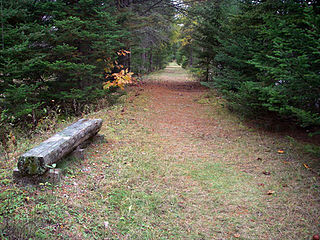
Cape Henlopen State Park is a Delaware state park on 5,193 acres (2,102 ha) on Cape Henlopen in Sussex County, Delaware, in the United States. William Penn made the beaches of Cape Henlopen one of the first public lands established in what has become the United States in 1682 with the declaration that Cape Henlopen would be for "the usage of the citizens of Lewes and Sussex County." Cape Henlopen State Park has a 24-hour and year-round fishing pier as well as campgrounds. The remainder of the park is only open from sunrise to sunset, and includes a bathhouse on the Atlantic Ocean, an area for surf-fishing, a disc golf course, and bicycle and walking paths. The beach at Herring Point is a popular surfing spot. The park is a stop on Delaware's Coastal Heritage Greenway.

Barnegat Bay is a small brackish arm of the Atlantic Ocean, approximately 42 miles (67.2 km) long, along the coast of Ocean County, New Jersey in the United States. It is separated from the Atlantic by the long Barnegat Peninsula, as well as by the north end of Long Beach Island, popular segments of the Jersey Shore. The bay is fed by several small rivers, including the Toms River and Metedeconk River, which empty into the bay through small estuaries along its inner shore. The communities of Toms River, Silverton, and Forked River sit along the river estuaries on the bay.

Delaware Route 1 (DE 1) is a 103.02-mile-long (165.79 km) state highway in the U.S. state of Delaware. The route runs from the Maryland border in Fenwick Island, Sussex County, where it continues south into that state as Maryland Route 528 (MD 528), north to an interchange with DE 58 in Christiana, New Castle County, where the road continues north as DE 7. Between Fenwick Island and Dover Air Force Base in Dover, Kent County, DE 1 is a four- to six-lane surface divided highway with occasional interchanges. The route heads north past the Delaware Beaches along the Atlantic Ocean before it runs northwest through rural areas, turning north at Milford to continue to Dover. Upon reaching Dover, DE 1 becomes the Korean War Veterans Memorial Highway, a four- to six-lane freeway that is tolled. Between Dover and Tybouts Corner, DE 1 parallels U.S. Route 13 (US 13), crossing over and featuring interchanges with it multiple times. Past Tybouts Corner, the freeway heads north to Christiana, reaching an interchange with Interstate 95 (I-95) a short distance before its terminus. DE 1 serves as the main north-south state route in Delaware, connecting the Delaware Beaches with the Dover and Wilmington areas.

The Bombay Hook National Wildlife Refuge is a 15,978 acres (64.66 km2) National Wildlife Refuge located along the eastern coast of Kent County, Delaware, United States, on Delaware Bay. It was established on March 16, 1937 as a refuge and breeding ground for migratory and wintering waterfowl along the Atlantic Flyway. The Refuge was purchased from local land owners with federal duck stamp funds.
St. Georges Hundred is an unincorporated subdivision of New Castle County, Delaware. Hundreds were once used as a basis for representation in the Delaware General Assembly, and while their names still appear on all real estate transactions, they presently have no meaningful use or purpose except as a geographical point of reference.
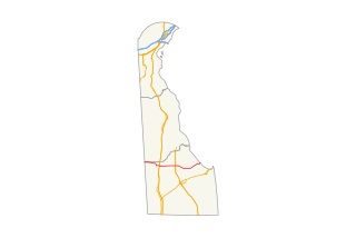
Delaware Route 16 is an east-west state highway in Delaware, mainly across northern Sussex County, with a small portion near the Maryland border in extreme southwestern Kent County. It runs from Maryland Route 16 at the Maryland border in Hickman to the Delaware Bay at Broadkill Beach. The route runs through rural areas, passing through the towns of Greenwood, Ellendale, and Milton. DE 16 intersects U.S. Route 13 and DE 36 in Greenwood, US 113 in Ellendale, DE 30 and DE 5 in the Milton area, and DE 1 between Milton and Broadkill Beach. West of DE 1, the route serves as part of a connection between the Baltimore-Washington Metropolitan Area and the Delaware Beaches. DE 16 was built as a state highway during the 1920s and 1930s. By 1936, the route was designated onto its current alignment.

Delaware Route 54 and Maryland Route 54 are adjoining state highways in the U.S. states of Delaware and Maryland. Route 54 runs 41.84 mi (67.33 km) from MD 313 in Mardela Springs, Maryland east to DE 1 in Fenwick Island, Delaware. In addition to two segments in which the highway is completely in Delaware and two segments in which the highway is completely in Maryland, Route 54 follows the Delaware/Maryland state line between the twin towns of Delmar, Maryland and Delmar, Delaware and the highway's intersection with MD 353 and DE 26. One section of the state line portion of Route 54 is maintained by the Delaware Department of Transportation (DelDOT) while three sections of the highway that follow the state line are maintained by the Maryland State Highway Administration (MDSHA).

Delaware Route 20 is an east–west state highway in Sussex County, Delaware. Its western terminus is the Maryland state line in Reliance, where it continues as Maryland Route 392. Its eastern terminus is DE 54 west of Fenwick Island. The route runs through rural areas of Sussex County and passes through the towns of Seaford, Millsboro, and Dagsboro. DE 20 intersects U.S. Route 13 in Seaford, US 9 in Hardscrabble, US 113 and DE 24/DE 30 in Millsboro, DE 26 in Dagsboro, and DE 17 in Roxana. DE 20 was originally created by 1936 to run from the Maryland border east to US 113 in Millsboro. By 1970, it was realigned to bypass Seaford. The route was extended east to DE 1 in Fenwick Island by 1994; however, the eastern terminus was cut back to DE 54 in 2005 to avoid the concurrency with that route.

Delaware Route 9 is a 58.18-mile (93.63 km) state highway that connects DE 1 at the Dover Air Force Base in Kent County to DE 2 in the city of Wilmington in New Castle County. DE 9 is a designated scenic highway known as the Delaware's Bayshore Byway south of New Castle, running through mostly rural areas to the west of the Delaware Bay and the Delaware River as a two-lane undivided road. Between New Castle and Wilmington, DE 9 is a four-lane road that runs through urban and suburban areas. DE 9 passes through several cities and towns including Little Creek, Leipsic, Port Penn, Delaware City, and New Castle. DE 9 has a suffixed route, DE 9A, that provides access to the Port of Wilmington. In addition, it has a truck route, DE 9 Truck, located to the south of New Castle.
The New Jersey Coastal Heritage Trail Route extends along eastern and southern coast of New Jersey for nearly 300 miles. It travels along the Raritan Bay from Perth Amboy to Sandy Hook, along Jersey Shore at the Atlantic Ocean to Cape May, and along the Delaware Bay to the Delaware Memorial Bridge. The trail encompasses a variety of New Jersey state parks along with facilities under the jurisdiction of the National Park Service.
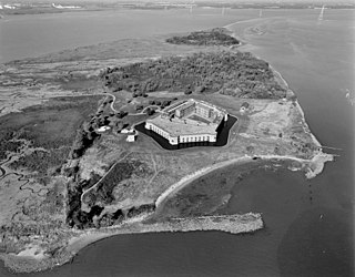
Fort Delaware State Park is a 288-acre (117 ha) Delaware state park on Pea Patch Island in New Castle County, Delaware, in the United States. A fortress was built on Pea Patch Island by the United States Army in 1815, near the conclusion of the War of 1812, to protect the harbors of Wilmington, Delaware and Philadelphia, Pennsylvania. The fort was burned and rebuilt in the years prior to the American Civil War, and soon after the start of the war the fort was converted to a Prisoner of War camp. Fort Delaware continued to protect the mouth of the Delaware River through World War I and II. Pea Patch Island and Fort Delaware was declared surplus land by the United States Department of Defense in 1945.
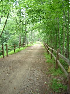
Delaware Bicycle Route 1 is a bicycle route that runs the north-south length of the U.S. state of Delaware, from the Maryland border in Fenwick Island, Sussex County north to the Pennsylvania border near Montchanin, New Castle County. The route passes through many Delaware scenes, including beaches, farmland, state parks, and towns. The route is the first of many signed bike routes planned in the state.

Fox Point State Park is a Delaware state park on 108 acres (44 ha) along the Delaware River in New Castle County, Delaware in the United States. The park, which opened in 1995, has been built atop a former hazardous waste site that has been rehabilitated under an adaptive reuse program that was spearheaded by S. Marston Fox and the Fox Point Civic Association. Fox Point State Park is open for year-round use from 8:00 am until sunset. The park offers recreational opportunities on biking and pedestrian trails with picnic facilities, a playground and volleyball and horseshoes facilities. Fox Point State Park is just off Interstate 495 and is the northern terminus of Delaware's Coastal Heritage Greenway.
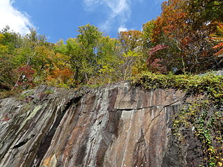
Alapocas Run State Park is a state park, located in Wilmington, Delaware, United States, along the Brandywine Creek and its Alapocas Run tributary. Open year-round, it is 415 acres (168 ha) in area. Much of the state park was created from land originally preserved by William Poole Bancroft in the early 1900s to be used as open space parkland by the city of Wilmington as it expanded. The park also includes the Blue Ball Barn, a dairy barn built by Alfred I. du Pont as part of his Nemours estate in 1914. In addition to walking trails, athletic fields, and playgrounds for children, one of the park's primary features is a rock climbing wall. The rock climbing wall is part of an old quarry across from historic Bancroft Mills on the Brandywine, and the quarry is also used for school educational programs centered on earth sciences.