Woodland Beach Wildlife Area

Last updated
Oblique air photo of Woodland Beach Wildlife Area, April 2010, facing east Woodland Beach Wildlife Area airphoto.jpg
Oblique air photo of Woodland Beach Wildlife Area, April 2010, facing east

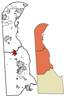
Woodland Beach Wildlife Area is a state wildlife area located in Kent County, Delaware, along shore of the Delaware Bay. It is 6,320 acres (2,558 ha) in size and is managed by Delaware Department of Natural Resources and Environmental Control (DNREC), Division of Fish & Wildlife. [1]

Kent County, Delaware county in Delaware, United States

Kent County is a county located in the central part of the U.S. state of Delaware. As of the 2010 census, the population was 162,310, making it the least populous county in Delaware. The county seat is Dover, the state capital of Delaware. It is named for Kent, an English county.

Delaware State of the United States of America

Delaware is one of the 50 states of the United States, in the Mid-Atlantic or Northeastern region. It is bordered to the south and west by Maryland, north by Pennsylvania, and east by New Jersey and the Atlantic Ocean. The state takes its name from Thomas West, 3rd Baron De La Warr, an English nobleman and Virginia's first colonial governor.

Delaware Bay The estuary outlet of the Delaware River on the Northeast seaboard of the United States

Delaware Bay is the estuary outlet of the Delaware River on the Northeast seaboard of the United States. Approximately 782 square miles (2,030 km2) in area, the bay's fresh water mixes for many miles with the salt water of the Atlantic Ocean.

Much of the area is a transgressive brackish marsh.

Brackish marsh marsh with brackish levels of salinity

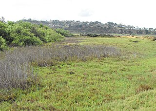
Brackish marshes develop by salt marshes where a significant freshwater influx dilutes the seawater to brackish levels of salinity. This commonly happens upstream from salt marshes by estuaries of coastal rivers or near the mouths of coastal rivers with heavy freshwater discharges in the conditions of low tidal ranges.

Marsh A wetland that is dominated by herbaceous rather than woody plant species

A marsh is a wetland that is dominated by herbaceous rather than woody plant species. Marshes can often be found at the edges of lakes and streams, where they form a transition between the aquatic and terrestrial ecosystems. They are often dominated by grasses, rushes or reeds. If woody plants are present they tend to be low-growing shrubs. This form of vegetation is what differentiates marshes from other types of wetland such as swamps, which are dominated by trees, and mires, which are wetlands that have accumulated deposits of acidic peat.

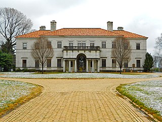
The Thomas Sutton House serves as a residence and office for the personnel of the Woodland Beach Wildlife Area. It was listed on the National Register of Historic Places in 1973. [2]

Thomas Sutton House

Thomas Sutton House, also known as the House on Game Preserve, is a historic home located at Woodland Beach, Kent County, Delaware. It was built about 1733, and is a two-story stuccoed brick house, constructed on a single pile, hall and parlor plan. It has a lower two-story wing that extends the axis of the main house. It serves as a residence and office for the personnel of the Woodland Beach Wildlife Area.

National Register of Historic Places federal list of historic sites in the United States

The National Register of Historic Places (NRHP) is the United States federal government's official list of districts, sites, buildings, structures, and objects deemed worthy of preservation for their historical significance. A property listed in the National Register, or located within a National Register Historic District, may qualify for tax incentives derived from the total value of expenses incurred preserving the property.

Coordinates: 39°20′N75°30′W / 39.333°N 75.500°W / 39.333; -75.500

Geographic coordinate system Coordinate system

A geographic coordinate system is a coordinate system that enables every location on Earth to be specified by a set of numbers, letters or symbols. The coordinates are often chosen such that one of the numbers represents a vertical position and two or three of the numbers represent a horizontal position; alternatively, a geographic position may be expressed in a combined three-dimensional Cartesian vector. A common choice of coordinates is latitude, longitude and elevation. To specify a location on a plane requires a map projection.

Related Research Articles

Lewes, Delaware City in Delaware, United States

Lewes is an incorporated city on the Delaware Bay in eastern Sussex County, Delaware. According to the 2010 census, the population is 2,747. Along with neighboring Rehoboth Beach, Lewes is one of the principal cities of Delaware's rapidly growing Cape Region. The city lies within the Salisbury, Maryland–Delaware Metropolitan Statistical Area. Lewes proudly claims to be "The First Town in The First State."

Kenton, Delaware Town in Delaware, United States

Kenton is a town in Kent County, Delaware, United States. It is part of the Dover, Delaware Metropolitan Statistical Area. The population was 261 at the 2010 census.

Smyrna, Delaware Town in Delaware, United States

Smyrna is a town in Kent and New Castle counties in the U.S. state of Delaware. It is part of the Dover, Delaware Metropolitan Statistical Area. According to the Census Bureau, as of 2010, the population of the town is 10,023.

Woodside, Delaware Town in Delaware, United States

Woodside is a town in Kent County, Delaware, United States. It is part of the Dover, Delaware Metropolitan Statistical Area. The population was 181 at the 2010 census.

Claymont, Delaware CDP in Delaware, United States

Claymont is a census-designated place (CDP) in New Castle County, Delaware, United States. The population was 8,253 at the 2010 census.

New Castle, Delaware City in Delaware, United States

New Castle is a city in New Castle County, Delaware, six miles (10 km) south of Wilmington, situated on the Delaware River. According to the 2010 Census, the population of the city is 5,285.

Slaughter Beach, Delaware Town in Delaware, United States

Slaughter Beach is a town in Sussex County, Delaware, United States. The population was 207 at the 2010 census, an increase of 4.5% over the past decade. It is part of the Salisbury, Maryland-Delaware Metropolitan Statistical Area.

Cape Henlopen

Cape Henlopen is the southern cape of the Delaware Bay along the Atlantic coast of the United States. It lies in the state of Delaware, near the town of Lewes. Off the coast on the bay side are two lighthouses, called the Harbor of Refuge Light and the Delaware Breakwater East End Light.

Red Clay Creek is a 13.6-mile-long (21.9 km) tributary of White Clay Creek, running through southeastern Pennsylvania and northern Delaware in the United States. As of 2000, portions of the creek are under wildlife habitat protection.

Ridley Creek State Park

Ridley Creek State Park is a 2,606-acre (1,055 ha) Pennsylvania state park in Edgmont, Middletown and Upper Providence Townships, Delaware County, Pennsylvania in the United States. The park, about 5 miles (8 km) north of the county seat of Media, offers many recreational activities, such as hiking, biking, fishing, and picnicking. Ridley Creek passes through the park. Highlights include a 5-mile (8 km) paved multi-use trail, a formal garden designed by the Olmsted Brothers, and Colonial Pennsylvania Plantation, which recreates daily life on a pre-Revolutionary farm. The park is adjacent to the John J. Tyler Arboretum. Ridley Creek State Park is just over 16 miles (26 km) from downtown, Philadelphia between Pennsylvania Route 352 and Pennsylvania Route 252 on Gradyville Road.

Marshallton, Delaware Unincorporated community in Delaware, United States

Marshallton is an unincorporated community in Mill Creek Hundred, New Castle County, Delaware, United States. The community was founded in 1836 and is named for John Marshall, mill owner.

Centerville, Delaware Unincorporated community in Delaware, United States

Centerville is an unincorporated community in New Castle County, Delaware, United States. Centerville is now known primarily for being the location of Du Pont family estates, as well as several other wealthy business families from nearby Wilmington, and the home of Governor Jack Markell.

The New Jersey Coastal Heritage Trail Route extends along eastern and southern coast of New Jersey for nearly 300 miles. It travels along the Raritan Bay from Perth Amboy to Sandy Hook, along Jersey Shore at the Atlantic Ocean to Cape May, and along the Delaware Bay to the Delaware Memorial Bridge. The trail encompasses a variety of New Jersey state parks along with facilities under the jurisdiction of the National Park Service.

Clarksville, Delaware Unincorporated community in Delaware, United States

Clarksville is an unincorporated community in Baltimore Hundred, Sussex County, Delaware, United States located just west of Millville. It is centered, more or less, along Delaware Route 26. Many tourists from the Baltimore–Washington metropolitan area pass through the town on their way to and from the Delaware Beaches.

Ruthsburg is an unincorporated community in Queen Anne's County, Maryland, United States. Ruthsburg made national headlines in 2009, when the proposed creation of a U.S. State Department training center spurred unexpected controversy between those who believed it would have devastated neighboring Tuckahoe State Park, the Chesapeake Bay, wildlife, agriculture, communities, and the region as a whole and those who believed it would lead to economic benefits for local businesses, including local firms involved in the construction of the facility, 500 new jobs were forecasted to be brought by the facility, and additional new people brought to the area as transfers who would then be participants in the local economy. In mid-2010, the State Department scrapped plans for the facility.

Southern Shore Region

The Southern Shore Region is located in the southeastern part of State of New Jersey in the United States of America. It is one of six tourism regions established by the New Jersey State Department of Tourism, the others being the Gateway Region, Greater Atlantic City, the Delaware River Region, the Shore Region and the Skylands Region. The area includes Cape May County and Cumberland County. The coast is along the Atlantic Ocean and Delaware Bay, while the inland areas are part of the New Jersey Pine Barrens.

Little Heaven, Delaware Unincorporated community in Delaware, United States

Little Heaven is an unincorporated community in Kent County, Delaware. Its elevation is 26 ft (7.9 m) and its position 39°02′30″N75°27′24″W. It is north of Frederica at the intersection of Delaware Route 1 and Clapham Road.

Woodland Beach, Delaware Unincorporated community in Delaware, United States

Woodland Beach is an unincorporated community in Kent County, Delaware, United States. Woodland Beach is along the Delaware Bay east of Smyrna at the eastern terminus of Delaware Route 6. The Woodland Beach Wildlife Area is located in Woodland Beach.

Thornton, Pennsylvania in Pennsylvania, United States

Thornton is an unincorporated community spanning Thornbury Township, Concord Township and Middletown Township, Delaware County, Pennsylvania, United States.

References