Coastline of the North Sea

Last updated
The German North Sea coast Wattenmeer-Nordfriesland.jpg
The German North Sea coast

The coastline of the North Sea has been evolving since the end of the last ice age. The coastline varies from fjords, river estuaries to mudflats.

Contents

The eastern and western coasts of the North Sea are jagged, as they were stripped by glaciers during the ice ages. The coastlines along the southernmost part are soft, covered with the remains of deposited glacial sediment, which was left directly by the ice or has been redeposited by the sea. [1] The Norwegian mountains plunge into the sea, giving rise, north of Stavanger, to deep fjords and archipelagos. South of Stavanger, the coast softens, the islands become fewer. [1] The eastern Scottish coast is similar, though less severe than Norway. Starting from Flamborough Head in the north east of England, the cliffs become lower and are composed of less resistant moraine, which erodes more easily, so that the coasts have more rounded contours. [2] [3] In the Netherlands, Belgium and in the east of England (East Anglia) the littoral is low and marshy. [1] The east coast and south-east of the North Sea (Wadden Sea) have coastlines that are mainly sandy and straight owing to longshore currents, particularly along Belgium and Denmark. [4] [5] [6]

Northern fjords, skerries, and cliffs

Lysefjord in Norway. Lysefjorden - View from Lysebotn.JPG
Lysefjord in Norway.

The northern North Sea coasts bear the impression of the enormous glaciers which covered them during the Ice Ages and created fjords, lakes and valleys along the coastline and landscape. Fjords arose by the action of glaciers, which dragged their way through them from the highlands, cutting and scraping deep trenches in the land. Fjords are particularly common on the coast of Norway. [6] [7] [8]

Firths are similar to fjords, but are generally shallower with broader bays in which small islands may be found. [9] The glaciers that formed them influenced the land over a wider area and scraped away larger areas. [10] Firths are to be found on the Scottish coast. [11] Individual islands in the firths, or islands and the coast, are often joined up by sandbars or spits made up of sand deposits known as "tombolos". [12] [13]

North Sea cliff 2004 07 31-L51 ubt.jpeg
North Sea cliff

Towards the south the firths give way to a cliff coast, which was formed by the moraines of Ice Age glaciers. [2] The horizontal impact of waves on the North Sea coast gives rise to eroded coasts. [2] [3] The cliff landscape is interrupted in southern England by large estuaries with their corresponding fringing marshes, notably the Humber and the Thames. [8] [14] [15]

There are skerries in southern Norway formed by similar action to that which created the fjords and firths. The glaciers in these places affected the land to an even greater extent, so that large areas were scraped away. The coastal brim (Strandflaten), which is found especially in southern Norway, is a gently sloping lowland area between the sea and the mountains. It consists of plates of rock platforms, and often extends for kilometres, reaching under the sea, at a depth of only a few metres. [16]

Southern shoals and mudflats

Seashore at Zandvoort aan Zee Zandvoort aan Zee (19).jpg
Seashore at Zandvoort aan Zee

The shallow-water coasts of the southern and eastern coast up to Denmark were formed by ice age activity, but their particular shape is determined for the most part by the sea and sediment deposits. [17]

Mudflats in Germany Tidal flats.jpg
Mudflats in Germany

The Wadden Sea stretches between Esbjerg, Denmark in the north and Den Helder, Netherlands in the west. This landscape is heavily influenced by the tides and important sections of it have been declared a National Park. [18] The whole of the coastal zone is shallow; the tides flood large areas and uncover them again, constantly depositing sediments. [19] The Southern Bight has been especially changed by land reclamation, as the Dutch have been especially active. [19] The largest project of this type was the diking and reclamation of the IJsselmeer. [20]

Tidal forces have formed the Frisian Islands. In the micro tidal area, (a tidal range of up to 1.35 meters (4.4 ft), such as on the Dutch or Danish coasts, [21] barrier beaches with dunes are formed. [19] [22] :[217] In the mesotidal area (a tidal range of between 1.35 and 2.9 m (4.4 and 9.5 ft)), barrier islands are formed; [22] :[309,488] in the macrotidal area (above 2.9 meters (9.5 ft) tidal range), intertidal deposits raise the spring tide range 4 meters (13 ft). [19] [22] :[30–31] A soft rock coast is formed in the meso-macro tidal areas located in the southern North Sea. These soft rock coastal bedrock plains are interspersed with soft rock (shale and sandstone) cliffs. [23]

The small, historically strategic island of Heligoland was not formed by recent sediment deposition; it is considerably older and is composed of early Triassic sandstone. [24]

See also

Related Research Articles

<span class="mw-page-title-main">Coast</span> Area where land meets the sea or ocean

The coast, also known as the coastline, shoreline or seashore, is defined as the area where land meets the ocean, or as a line that forms the boundary between the land and the coastline. Shores are influenced by the topography of the surrounding landscape, as well as by water induced erosion, such as waves. The geological composition of rock and soil dictates the type of shore which is created. The Earth has around 620,000 kilometres (390,000 mi) of coastline. Coasts are important zones in natural ecosystems, often home to a wide range of biodiversity. On land, they harbor important ecosystems such as freshwater or estuarine wetlands, which are important for bird populations and other terrestrial animals. In wave-protected areas they harbor saltmarshes, mangroves or seagrasses, all of which can provide nursery habitat for finfish, shellfish, and other aquatic species. Rocky shores are usually found along exposed coasts and provide habitat for a wide range of sessile animals and various kinds of seaweeds. In physical oceanography, a shore is the wider fringe that is geologically modified by the action of the body of water past and present, while the beach is at the edge of the shore, representing the intertidal zone where there is one. Along tropical coasts with clear, nutrient-poor water, coral reefs can often be found between depths of 1–50 meters.

<span class="mw-page-title-main">North Sea</span> Marginal sea of the Atlantic Ocean

The North Sea lies between Great Britain, Denmark, Norway, Germany, the Netherlands, Belgium and France. An epeiric sea on the European continental shelf, it connects to the Atlantic Ocean through the English Channel in the south and the Norwegian Sea in the north. It is more than 970 kilometres (600 mi) long and 580 kilometres (360 mi) wide, covering 570,000 square kilometres (220,000 sq mi).

<span class="mw-page-title-main">Fjord</span> Long, narrow inlet with steep sides or cliffs, created by glacial activity

In physical geography, a fjord or fiord is a long, narrow sea inlet with steep sides or cliffs, created by a glacier. Fjords exist on the coasts of Antarctica, the Arctic, and surrounded landmasses of the northern and southern hemispheres. Norway's coastline is estimated to be 29,000 km (18,000 mi) long with its nearly 1,200 fjords, but only 2,500 km (1,600 mi) long excluding the fjords.

<span class="mw-page-title-main">Estuary</span> Partially enclosed coastal body of brackish water

An estuary is a partially enclosed coastal body of brackish water with one or more rivers or streams flowing into it, and with a free connection to the open sea. Estuaries form a transition zone between river environments and maritime environments and are an example of an ecotone. Estuaries are subject both to marine influences such as tides, waves, and the influx of saline water, and to fluvial influences such as flows of freshwater and sediment. The mixing of seawater and freshwater provides high levels of nutrients both in the water column and in sediment, making estuaries among the most productive natural habitats in the world.

<span class="mw-page-title-main">Lagoon</span> Shallow body of water separated from a larger one by a narrow landform

A lagoon is a shallow body of water separated from a larger body of water by a narrow landform, such as reefs, barrier islands, barrier peninsulas, or isthmuses. Lagoons are commonly divided into coastal lagoons and atoll lagoons. They have also been identified as occurring on mixed-sand and gravel coastlines. There is an overlap between bodies of water classified as coastal lagoons and bodies of water classified as estuaries. Lagoons are common coastal features around many parts of the world.

<span class="mw-page-title-main">Shoal</span> Natural submerged sandbank that rises from a body of water to near the surface

In oceanography, geomorphology, and geoscience, a shoal is a natural submerged ridge, bank, or bar that consists of, or is covered by, sand or other unconsolidated material, and rises from the bed of a body of water close to the surface or above it, which poses a danger to navigation. Shoals are also known as sandbanks, sandbars, or gravelbars. Two or more shoals that are either separated by shared troughs or interconnected by past or present sedimentary and hydrographic processes are referred to as a shoal complex.

Landforms are categorized by characteristic physical attributes such as their creating process, shape, elevation, slope, orientation, rock exposure, and soil type.

<span class="mw-page-title-main">Barrier island</span> Coastal dune landform that forms by wave and tidal action parallel to the mainland coast

Barrier islands are a coastal landform—a type of dune system and sand island—where an area of sand has been formed by wave and tidal action parallel to the mainland coast. They usually occur in chains, consisting of anything from a few islands to more than a dozen. They are subject to change during storms and other action, but absorb energy and protect the coastlines and create areas of protected waters where wetlands may flourish. A barrier chain may extend for hundreds of kilometers, with islands periodically separated by tidal inlets. The largest barrier island in the world is Padre Island of Texas, United States, at 113 miles (182 km) long. Sometimes an important inlet may close permanently, transforming an island into a peninsula, thus creating a barrier peninsula, often including a beach, barrier beach. Though many are long and narrow, the length and width of barriers and overall morphology of barrier coasts are related to parameters including tidal range, wave energy, sediment supply, sea-level trends, and basement controls. The amount of vegetation on the barrier has a large impact on the height and evolution of the island.

<span class="mw-page-title-main">Submergent coastline</span> Stretches of coast that have been inundated by the sea by a relative rise in sea levels

Submergent coastlines or drowned coastlines are stretches along the coast that have been inundated by the sea by a relative rise in sea levels from either isostacy or eustacy.

<span class="mw-page-title-main">Moray Firth</span> Inlet near Inverness, Scotland

The Moray Firth is a roughly triangular inlet of the North Sea, north and east of Inverness, which is in the Highland council area of north of Scotland.

<span class="mw-page-title-main">Inlet</span> Indentation of a shoreline

An inlet is a indentation of a shoreline, such as a small arm, cove, bay, sound, fjord, lagoon or marsh, that leads to an enclosed larger body of water such as a lake, estuary, gulf or marginal sea.

<span class="mw-page-title-main">Tidal marsh</span> Marsh subject to tidal change in water

A tidal marsh is a marsh found along rivers, coasts and estuaries which floods and drains by the tidal movement of the adjacent estuary, sea or ocean. Tidal marshes experience many overlapping persistent cycles, including diurnal and semi-diurnal tides, day-night temperature fluctuations, spring-neap tides, seasonal vegetation growth and decay, upland runoff, decadal climate variations, and centennial to millennial trends in sea level and climate.

<span class="mw-page-title-main">Coastal geography</span> Study of the region between the ocean and the land

Coastal geography is the study of the constantly changing region between the ocean and the land, incorporating both the physical geography and the human geography of the coast. It includes understanding coastal weathering processes, particularly wave action, sediment movement and weather, and the ways in which humans interact with the coast.

<span class="mw-page-title-main">Bay</span> Recessed, coastal body of water connected to an ocean or lake

A bay is a recessed, coastal body of water that directly connects to a larger main body of water, such as an ocean, a lake, or another bay. A large bay is usually called a gulf, sea, sound, or bight. A cove is a small, circular bay with a narrow entrance. A fjord is an elongated bay formed by glacial action. The term embayment is also used for related features, such as extinct bays or freshwater environments.

<span class="mw-page-title-main">Sedimentary budget</span>

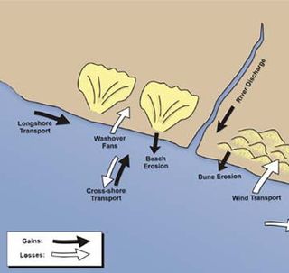
Sedimentary budgets are a coastal management tool used to analyze and describe the different sediment inputs (sources) and outputs (sinks) on the coasts, which is used to predict morphological change in any particular coastline over time. Within a coastal environment the rate of change of sediment is dependent on the amount of sediment brought into the system versus the amount of sediment that leaves the system. These inputs and outputs of sediment then equate to the total balance of the system and more than often reflect the amounts of erosion or accretion affecting the morphology of the coast.

<span class="mw-page-title-main">Fjard</span> Glacially formed, broad, shallow inlet

A fjard is a large open space of water between groups of islands or mainland in archipelagos. Fjards can be found along sea coasts, in freshwater lakes or rivers. Fjard and fjord were originally the same word with the general meaning of sailable waterway. In Scandinavia, fjords dominate along the North Sea coast while fjards dominate the Baltic Sea coast.

Kangerlussuaq Fjord is a long fjord in the Qeqqata municipality in central-western Greenland. The fjord is 190 km (120 mi) long and between 1.5 km (0.93 mi) and 8 km (5.0 mi) wide, flowing from the estuary of Qinnguata Kuussua river to the southwest, and emptying into the Davis Strait. It is the longest fjord of western Greenland.

<span class="mw-page-title-main">Marine habitat</span> Habitat that supports marine life

A marine habitat is a habitat that supports marine life. Marine life depends in some way on the saltwater that is in the sea. A habitat is an ecological or environmental area inhabited by one or more living species. The marine environment supports many kinds of these habitats.

<span class="mw-page-title-main">Overdeepening</span> Characteristic of basins and valleys eroded by glaciers

Overdeepening is a characteristic of basins and valleys eroded by glaciers. An overdeepened valley profile is often eroded to depths which are hundreds of metres below the lowest continuous surface line along a valley or watercourse. This phenomenon is observed under modern day glaciers, in salt-water fjords and fresh-water lakes remaining after glaciers melt, as well as in tunnel valleys which are partially or totally filled with sediment. When the channel produced by a glacier is filled with debris, the subsurface geomorphic structure is found to be erosionally cut into bedrock and subsequently filled by sediments. These overdeepened cuts into bedrock structures can reach a depth of several hundred metres below the valley floor.

<span class="mw-page-title-main">Goldthwait Sea</span> Prehistoric sea on the coast of eastern Canada

The Goldthwait Sea was a sea that emerged during the last deglaciation, starting around 13,000 years ago, covering what is now the Gulf of Saint Lawrence and surrounding areas. At that time, the land had been depressed under the weight of the Laurentide Ice Sheet, which was up to 2 kilometres (1.2 mi) thick. Areas on the Anticosti Island and low-lying regions of Quebec and the Maritimes bordering the Saint Lawrence were below sea level. As the land rebounded over the next 3,000 years, despite rising sea levels the sea retreated to roughly the present boundaries of the Gulf.

References

  1. 1 2 3 L.M.A. (1985). "Europe". In University of Chicago (ed.). Encyclopædia Britannica Macropædia. Vol. 18 (Fifteenth ed.). U.S.A.: Encyclopædia Britannica Inc. pp. 832–835. ISBN   978-0-85229-423-9.
  2. 1 2 3 "Development of the East Riding Coastline" (PDF). East Riding of Yorkshire Council. Archived from the original (PDF) on 2007-08-10. Retrieved 2007-07-24.
  3. 1 2 "Holderness Coast United Kingdom" (PDF). EUROSION Case Study. Retrieved 2007-07-24.
  4. Koster, Eduard A. (2005). "The Danish North Sea Coast" (Digitized by Google Books online). The Physical Geography of Western Europe. Oxford University Press. p. 134. ISBN   978-0-19-927775-9 . Retrieved 2008-12-05.
  5. Verwaest, Toon; Peter De Wolf; Jean-Louis Leten; Marc Leten (2005-11-23). "Windows in the dunes – the creation of sea inlets in the nature reserve de Westhoek in De Panne" (PDF). in Herrier J.-L., J. Mees, A. Salman, J. Seys, H. Van Nieuwenhuyse, & I. Dobbelaere (Eds.) Proceedings ‘Dunes and Estuaries 2005’ – International Conference on Nature Restoration Practices in European Coastal Habitats. Koksijde, Belgium: Flanders Marine Institute (VLIZ). pp. 433–439. Retrieved 2008-11-02.
  6. 1 2 "Overview of geography, hydrography and climate of the North Sea (Chapter II of the Quality Status Report" (PDF). Convention for the Protection of the Marine Environment of the North-East Atlantic (OSPAR). 2000. Archived from the original (PDF) on 2007-07-10. Retrieved 2007-12-04.
  7. Geological Society of London (1877). "And Cirques in Norway and Greenland". The Quarterly Journal of the Geological Society of London (Digitized by Internet Archive online). HighWire Press: Published by The Society. pp.  173–176. Retrieved 2008-12-05. fjords glaciers Norway.
  8. 1 2 International EMECS Center (2003). Environmental Guidebook 5: North Sea (PDF). International Center for the Environmental Management of Enclosed Coastal Seas (EMECS). Archived from the original (PDF) on 2008-12-17. Retrieved 2007-07-24.
  9. Philip George and son, ltd (1882). Philips' elementary atlas and geography, ed. by J.F. Williams (Digitized June 12, 2006 by Internet Archive online). pp.  15 . Retrieved 2008-12-05. Firths North Sea.
  10. Croll, James (1885). Climate and Time in Their Geological Relations: A Theory of Secular Changes of the Earth's Climate (Digitized 2006-05-15 by Internet Archive online). Original from Oxford University England: A. and C. Black. pp.  443–444. ISBN   978-0-7486-6228-9 . Retrieved 2008-12-05. Climate and Time in Their Geological Relations: A Theory of Secular Changes of the Earth's Climate.
  11. Cramb, Auslan; Magnus Magnusson (1998). "Marine Environment" (Digitized by Google Books online). Fragile Land: Scotland's Environment. Edinburgh University Press. p. 101. ISBN   978-0-7486-6228-9 . Retrieved 2008-12-05.
  12. May, V. J.; J. D. Hansom (2003). Coastal Geomorphology of Great Britain (PDF). Geological Conservation Review Series, No. 28. Peterborough: Joint Nature Conservation Committee. pp. 754 pp. Retrieved 2008-11-02.
  13. Hansom, J. D. "St Ninian's Tombolo" (PDF). volume 28: Coastal Geomorphology of Great Britain from Geological Conservation Review Chapter 8: Sand spits and tombolos. Joint Nature Conservation Committee: 5pp. Archived from the original (PDF) on 2008-10-23. Retrieved 2008-11-01.{{cite journal}}: Cite journal requires |journal= (help)
  14. Penn, James R. (2001). Rivers of the World: A Social, Geographical, and Environmental Sourcebook (Digitized by Internet Archive online). ABC-CLIO. p.  107. ISBN   978-1-57607-042-0 . Retrieved 2008-12-05. coastline humber thames estuary.
  15. Allen, John R. L. (1992). Saltmarshes: Morphodynamics, Conservation, and Engineering Significance (Digitized by Google Books online). Kenneth Pye. Cambridge University Press. ISBN   978-0-521-41841-6 . Retrieved 2008-12-05.
  16. Seppälä, Matti (2005). "Atlantic Coasts and fjords Geoffrey D. Corner" (Digitized by Google Books online). The Physical Geography of Fennoscandia. Oxford University Press. p. 210. ISBN   978-0-19-924590-1.
  17. "Bridlington to Skegness: Habitat: Earth heritage". Natural England. Retrieved 2007-07-24.
  18. German MAB National Committee, ed. (2005). "5. Socio-Economic Monitoring in the Schleswig-Holstein Wadden Sea Region Christine Gatje" (Digitized by Google Books online). Full of Life: UNESCO Biosphere Reserves: Model Regions for Sustainable Development. Springer. p. 129. ISBN   978-3-540-20077-2 . Retrieved 2008-12-08.
  19. 1 2 3 4 Salman, Albert; Jos Rademakers (2007). "The Coastal Guide to The Dutch Coast". EUCC - The Coastal Union. Archived from the original on 2009-08-16. Retrieved 2008-12-04.
  20. "EarthShots: Satellite Images of Environmental Change IJsselmeer". U.S. Department of the Interior. 2007-05-01. Archived from the original on 2008-09-16. Retrieved 2008-12-04.
  21. Hollebrandse, Florenz A. P. "Temporal development of the tidal range in the southern North Sea" (PDF). Faculty of Civil Engineering and Geosciences. Delft University of Technology, Delft, The Netherlands. Archived from the original (PDF) on 2008-12-17. Retrieved 2008-11-02.
  22. 1 2 3 Eisma, D.; Poppe Lubberts de Boer (1998). Intertidal Deposits: River Mouths, Tidal Flats, and Coastal Lagoons (Digitized by Google Books online). CRC Press. p. 131. ISBN   978-0-8493-8049-5 . Retrieved 2008-12-04.
  23. "Habitat Dynamics at the Coast-Catchment Interface Synthesis Results Coastal habitat typology". European Land Ocean Interaction Studies. Archived from the original on 2009-01-07. Retrieved 2008-12-04.
  24. Jaeck, Joachim (2008-07-21). "History "Exotics" on Heligoland". Archived from the original on March 13, 2005. Retrieved 2008-12-04.