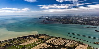
The Detroit River is an international river in North America. The river, which forms part of the border between the U.S. state of Michigan and the Canadian province of Ontario, flows west and south for 24 nautical miles from Lake St. Clair to Lake Erie as a strait in the Great Lakes system. The river divides the metropolitan areas of Detroit, Michigan, and Windsor, Ontario—an area collectively referred to as Detroit–Windsor. The Ambassador Bridge, the Detroit–Windsor Tunnel, and the Michigan Central Railway Tunnel connect the cities.

Windsor is a city in southwestern Ontario, Canada, on the south bank of the Detroit River directly across from Detroit, Michigan, United States. Geographically located within but administratively independent of Essex County, it is the southernmost city in Canada and marks the southwestern end of the Quebec City–Windsor Corridor. The city's population was 229,660 at the 2021 census, making it the third-most populated city in Southwestern Ontario, after London and Kitchener. This represents a 5.7 percent increase from Windsor's 2016 population census of 217,188. The Detroit–Windsor urban area is North America's most populous trans-border conurbation. Linking the Great Lakes Megalopolis, the Ambassador Bridge border crossing is the busiest commercial crossing on the Canada–United States border.
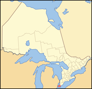
Essex County is a primarily rural county in Southwestern Ontario, Canada comprising seven municipalities: Amherstburg, Kingsville, Lakeshore, LaSalle, Leamington, Tecumseh and the administrative seat, Essex.

The yale or centicore is a mythical beast found in European mythology and heraldry.
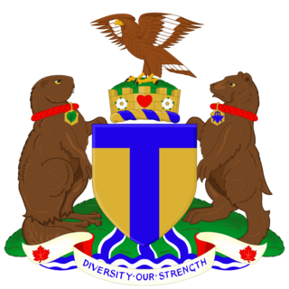
The coat of arms of Toronto is a heraldic symbol used to represent the city Toronto. Designed by Robert Watt, the Chief Herald of Canada at the time, for the City of Toronto after its amalgamation in 1998. The arms were granted by the Canadian Heraldic Authority on 11 January 1999.

The Detroit–Windsor tunnel, also known as the Detroit–Canada tunnel, is an international highway tunnel connecting the cities of Detroit, Michigan, United States and Windsor, Ontario, Canada. It is the second-busiest crossing between the United States and Canada, the first being the Ambassador Bridge, which also connects the two cities, which are situated on the Detroit River.
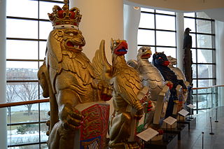
The Queen's Beasts are ten heraldic statues representing the genealogy of Queen Elizabeth II, depicted as the Royal supporters of England. They stood in front of the temporary western annexe to Westminster Abbey for the Queen's coronation in 1953. Each of the Queen's Beasts consists of a heraldic beast supporting a shield bearing a badge or arms of a family associated with the ancestry of Queen Elizabeth II. They were commissioned by the British Ministry of Works from the sculptor James Woodford, who was paid the sum of £2,750 for the work. They were uncoloured except for their shields at the coronation. They are now on display in the Canadian Museum of History in Gatineau, Quebec.

The first coat of arms of Montreal was designed by Jacques Viger, the first mayor of Montreal, and adopted in 1833 by the city councillors. Modifications were made some one hundred five years later and adopted on 21 March 1938, and again on 13 September 2017, resulting in the version currently in use. The coat of arms was the only city emblem representing Montreal until 1981, when a stylized logo was developed for common daily use, reserving the coat of arms for ceremonial occasions.

Horace Elgin Dodge Sr. was an American automobile manufacturing pioneer and co-founder of Dodge Brothers Company.
The St. Clair Parkway, historically referred to as the River Road, is a scenic parkway in the Canadian province of Ontario. It travels alongside the St. Clair River from west of Wallaceburg to Sarnia, a distance of 41.8 kilometres (26.0 mi). It formed a portion of the route of Highway 40 until it was bypassed by an inland route that opened in the mid-1970s. The St. Clair River Parkway Commission maintained the route from 1966 until 2006, when it was disbanded and responsibility over the parkway transferred to Chatham-Kent and Lambton County, both of which designate the route as County Road 33. The communities of Port Lambton, Sombra, Courtright, Mooretown, Corunna and Froomfield are located along the parkway, all early settlements of the 19th century.

The flag of Windsor, Ontario, was designed by Hector Lacasse, former mayor of adjacent Tecumseh, during a local contest in 1971. The blue and white represent the Detroit River and Saint Lawrence Seaway, respectively. The flag contains the seal of the city in the upper left and a rose in the lower right, highlighting Windsor's alternate motto, "The Rose City"/"City of Roses." The city seal was replaced in 1992 by a corporate seal. The date of 1854 on the seal signifies the final date in which the railroad to Windsor was completely built and the city was formed by the amalgamation of several other settlements. It is also the date that it was founded as a town.

The coat of arms of Calgary was adopted in 1902. The arms existed only in black and white until 1984, when an alderman asked the city to develop it in full colour.
The Ganatchio Trail is the second bike trail built in Windsor, Ontario, Canada. Construction on the trail started upon the closure of Clairview Avenue. The trail extends over 5.3 km, and passes through several neighbourhoods, including Riverside and Little River, and serves Sandpoint Beach and Stop 26 Beach and Park. It was the second major trail constructed, after the Riverfront Bike Trail, with extensions east towards Tecumseh built in stages. The trail has a posted speed limit of 20 km/h. The Riverfront and the Ganatchio Trails are wide enough for two cycle lanes in each direction.
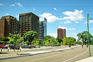
The Roy A. Battagello River Walk Bike Trail is the current backbone of the "Windsor Loop" bike trail network in Windsor, Ontario. The bike trail travels from the foot of the Ambassador Bridge, to traffic lights at Riverside Drive and Lincoln Avenue. This makes the trail the second-longest trail in the City of Windsor, at 8.0 km.
The Little River Extension is one of the newest and busiest recreational trails in Windsor, Ontario, having been built in 1996. The trail is used mainly as a link between the large subdivision of Forest Glade, to Ganatchio Trail, Sandpoint Beach, Stop 26 Beach, and Lakeview Park And Marina. The trail has a posted speed limit of 20 kilometres per hour (12 mph).
Windsor, Ontario, has a very diverse population, and this diversity is shown in its many neighbourhoods. Windsor has twenty in all, ranging from rural farmland to densely built-up areas.
King's Highway 39, commonly referred to as Highway 39, was a provincially maintained highway in the Canadian province of Ontario. The 33.8-kilometre (21.0 mi)-long route connected Highway 3 in downtown Windsor with Highway 2 south of Belle River, travelling along the southern shoreline of Lake St. Clair. Highway 39 was established in 1934. By 1961, the Pike Creek Bypass was opened and Highway 39 was rerouted along it, with the former route briefly becoming Highway 39B. The route was renumbered as Highway 2 in 1970, retiring the designation from the provincial highway system. Highway 2 was itself decommissioned along the former route of Highway 39 on January 1, 1998, and transferred to Essex County and the City of Windsor. It was subsequently redesignated as Essex County Road 22.

The Cornish–Windsor Covered Bridge is a 158-year-old, two-span, timber Town lattice-truss, interstate, covered bridge that crosses the Connecticut River between Cornish, New Hampshire, and Windsor, Vermont. Until 2008, when the Smolen–Gulf Bridge opened in Ohio, it had been the longest covered bridge in the United States.

Hotels in Toronto have been some of the most prominent buildings in the city and the hotel industry is one of the city's most important. The Greater Toronto Area has 183 hotels with a total of almost 36,000 rooms. In 2010, there were 8.9 million room nights sold. Toronto is a popular tourist destination, with it having the 6th highest room occupancy rate in North America, but about two thirds of rooms are taken by commercial, government, or convention travellers.

Windsor, Ontario was the first Canadian city with an electric street car system, which was introduced in 1886. Other Canadian cities soon followed suit, with St. Catharines in 1887 and Toronto in 1889. By World War I, nearly 50 Canadian cities had streetcar systems in place. By the time Windsor's streetcar system was dismantled in 1937, the system's scale was extensive and it serviced all 5 of the major riverfront communities of Windsor, Ford City, Sandwich, Walkerville and Ojibway.


