
Windsor is a city in southwestern Ontario, Canada, on the south bank of the Detroit River directly across from Detroit, Michigan, United States. Geographically located within but administratively independent of Essex County, it is the southernmost city in Canada and marks the southwestern end of the Quebec City–Windsor Corridor. The city's population was 229,660 at the 2021 census, making it the third-most populated city in Southwestern Ontario, after London and Kitchener. This represents a 5.7 percent increase from Windsor's 2016 population census of 217,188. The Detroit–Windsor urban area is North America's most populous trans-border conurbation. Linking the Great Lakes Megalopolis, the Ambassador Bridge border crossing is the busiest commercial crossing on the Canada–United States border.
King's Highway 401, commonly referred to as Highway 401 and also known by its official name as the Macdonald–Cartier Freeway or colloquially referred to as the four-oh-one, is a controlled-access 400-series highway in the Canadian province of Ontario. It stretches 828 kilometres (514 mi) from Windsor in the west to the Ontario–Quebec border in the east. The part of Highway 401 that passes through Toronto is North America's busiest highway, and one of the widest. Together with Quebec Autoroute 20, it forms the road transportation backbone of the Quebec City–Windsor Corridor, along which over half of Canada's population resides. It is also a Core Route in the National Highway System of Canada. The route is maintained by the Ministry of Transportation of Ontario (MTO) and patrolled by the Ontario Provincial Police. The speed limit is 100 km/h (62 mph) throughout the majority of its length, with the remaining exceptions being the posted 80 km/h (50 mph) limit westbound in Windsor, in most construction zones, and the 110 km/h (68 mph) speed limit on the 40 km (25 mi) stretch between Windsor and Tilbury that was raised on April 22, 2022, the 7 km (4.3 mi) extension east of the aforementioned, the 35 km (22 mi) stretch between Highway 35 / 115 and Cobourg, the 44 km (27 mi) stretch between Colborne and Belleville, the 66 km (41 mi) stretch between Belleville and Kingston, and the 107 km (66 mi) stretch between Highway 16 and the east end of the highway that were raised on July 12, 2024.
The E. C. Row Expressway is a municipal expressway in the city of Windsor, Ontario, Canada. It divides the city in half as it crosses it between the Ojibway Parkway in the west and Banwell Road in the east, a distance of 15.4 kilometres (9.6 mi). It was built between 1971 and 1983, reaching completion across the city on June 9, 1983. It was part of Highway 2 and Highway 18 until the province transferred ownership and responsibility for the route to the City of Windsor on April 1, 1997. In 2015, the westernmost 3 kilometres (1.9 mi) was significantly upgraded as part of the Highway 401 extension project. The freeway is named after Edgar Charles Row, the president of Chrysler Canada between 1951 and 1956.
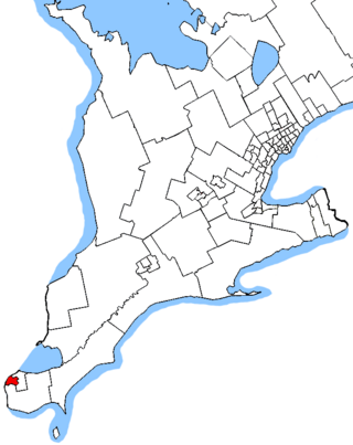
Windsor West is a federal electoral district in Ontario, Canada, that has been represented in the House of Commons of Canada since 1968.
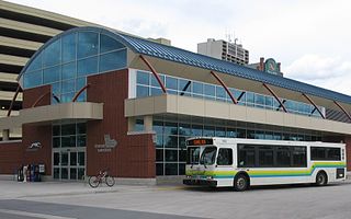
Transit Windsor provides public transportation in the city of Windsor, Ontario, Canada as well as LaSalle, Essex, Kingsville, Amherstburg and Leamington and serves more than 6 million passengers each year, covering an area of 310 km2 (120 sq mi) and a population of 235,000. They operate a cross border service between the downtown areas of Windsor and Detroit, Michigan, U.S via the Tunnel Bus, and service to events at Detroit's Comerica Park, Little Caesars Arena, Huntington Place, and Ford Field. The Windsor International Transit Terminal neighbours with the Windsor International Aquatic and Training Centre.
King's Highway 8, commonly referred to as Highway 8, is a provincially maintained highway in the Canadian province of Ontario. The 159.7-kilometre (99.2 mi) route travels from Highway 21 in Goderich, on the shores of Lake Huron, to Highway 5 in the outskirts of Hamilton near Lake Ontario. Before the 1970s, it continued east through Hamilton and along the edge of the Niagara Escarpment to the American border at the Whirlpool Bridge in Niagara Falls. However, the Queen Elizabeth Way (QEW) replaced the role of Highway 8 between those two cities, and the highway was subsequently transferred from the province to the newly formed Regional Municipality of Niagara in 1970. In 1998, the remaining portion east of Peters Corners was transferred to the city of Hamilton.
The Ganatchio Trail is the second bike trail built in Windsor, Ontario, Canada. Construction on the trail started upon the closure of Clairview Avenue. The trail extends over 5.3 km, and passes through several neighbourhoods, including Riverside and Little River, and serves Sandpoint Beach and Stop 26 Beach and Park. It was the second major trail constructed, after the Riverfront Bike Trail, with extensions east towards Tecumseh built in stages. The trail has a posted speed limit of 20 km/h. The Riverfront and the Ganatchio Trails are wide enough for two cycle lanes in each direction.
The Roy A. Battagello River Walk Bike Trail is the current backbone of the "Windsor Loop" bike trail network in Windsor, Ontario. The bike trail travels from the foot of the Ambassador Bridge, to traffic lights at Riverside Drive and Lincoln Avenue. This makes the trail the second-longest trail in the City of Windsor, at 8.0 km.
The Little River Extension is one of the newest and busiest recreational trails in Windsor, Ontario, Canada, having been built in 1996. The trail is used mainly as a link between the large subdivision of Forest Glade, to Ganatchio Trail, Sandpoint Beach, Stop 26 Beach, and Lakeview Park And Marina. The trail has a posted speed limit of 20 kilometres per hour (12 mph).
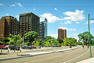
Riverside Drive is one of the main roads in Windsor, Ontario, Canada, travelling along the Detroit River, between its riverfront parks and high-rise office towers and apartment buildings. The road travels through Downtown, and towards the east end. The road is roughly 17.5 km in length, and is quite busy.
Windsor, Ontario, has a very diverse population, and this diversity is shown in its many neighbourhoods. Windsor has twenty in all, ranging from rural farmland to densely built-up areas.
King's Highway 39, commonly referred to as Highway 39, was a provincially maintained highway in the Canadian province of Ontario. The 33.8-kilometre (21.0 mi)-long route connected Highway 3 in downtown Windsor with Highway 2 south of Belle River, travelling along the southern shoreline of Lake St. Clair. Highway 39 was established in 1934. By 1961, the Pike Creek Bypass was opened and Highway 39 was rerouted along it, with the former route briefly becoming Highway 39B. The route was renumbered as Highway 2 in 1970, retiring the designation from the provincial highway system. Highway 2 was itself decommissioned along the former route of Highway 39 on January 1, 1998, and transferred to Essex County and the City of Windsor. It was subsequently redesignated as Essex County Road 22.
King's Highway 98, commonly referred to as Highway 98, was a provincially maintained highway in the Canadian province of Ontario, designated as part of the provincial highway system between 1939 and 1971. The route travelled through the northern part of Essex County and through south-central Chatham-Kent, extending 96.3 kilometres (59.8 mi) from Windsor to Blenheim. Since 1998, it has been known as Essex County Road 46 between Windsor and Tilbury, and Chatham-Kent Road 8 between Tilbury and Blenheim.
King's Highway 18, commonly referred to as Highway 18, was a provincially maintained highway in the Canadian province of Ontario, located entirely within Essex County. Since 1998, the majority of the former route has been known as Essex County Road 20. The route travelled at the southernmost point in Canada, along or near the shoreline of the Detroit River and Lake Erie between Windsor and Leamington, with Highway 3 as the terminus at both ends. The former route provides access to the communities of LaSalle, Amherstburg, Malden Centre, Harrow, Kingsville and Union.
Grand Marais Road is a road that travels through Windsor, Ontario. Its use and significance has dwindled considerably following the completion of the E.C. Row Expressway.

Ouellette Avenue is one of the main North-South Roads in Windsor, Ontario, and acts as its Main Street. The road diverges from Dougall Avenue south of Downtown Windsor, travelling northward over the Essex Terminal Railway/CP Rail tracks, before terminating at a turnaround and parking lot at Dieppe Gardens in Windsor's core.

King's Highway 3B, commonly referred to as Highway 3B, was a provincially maintained highway within Windsor, in the Canadian province of Ontario. Its purpose was to link Highway 3 and Highway 401 with the Detroit–Windsor tunnel and downtown Windsor. Highway 3B was routed along the city streets of Ouellette Avenue, Ouellette Place, Howard Avenue, and Dougall Avenue.
Dougall Avenue is a busy four-lane urban arterial road, linking Downtown Windsor, with South Windsor and Highway 401. The road is a minimum of four lanes for its entire length, and is among Windsor's busiest, with an Average Annual Daily Traffic amount of 35,000 vehicles per day from Eugenie Street to Cabana Road.

The Detroit metropolitan area in southeast Michigan is served by a comprehensive network of roads and highways. Three primary Interstate Highways pass through the region, along with three auxiliary Interstates, and multiple state and U.S. Highways. These are supplemented by the Mile Road System, a series of local roads spaced one mile apart on a perpendicular grid.