| Coledale | |
|---|---|
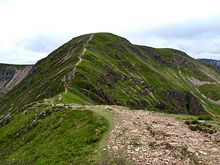
 Coledale seen from Coledale Hause with the vale of Keswick and the fell Blencathra in the background. |
Coledale is a valley in the northwestern region of the Lake District in Cumbria, England.
| Coledale | |
|---|---|
| Coledale seen from Coledale Hause with the vale of Keswick and the fell Blencathra in the background. |
Coledale is a valley in the northwestern region of the Lake District in Cumbria, England.
Coledale is a narrow U-shaped valley running approximately north-east towards the Derwent Valley floodplain and the village of Braithwaite at the northeastern end. The valley river Coledale Beck feeds into Newlands Beck and is fed by small streams from the valley sides and head, including Birkthwaite Beck, and Pudding Force.
At the head of the valley a large rock formation is found named Force Crag, which forms a waterfall 'Low Force' as Pudding Beck passes over it.
The valley is ringed by peaks popular with tourists ( Grisedale Pike , Hopegill Head , Coledale Hause , Crag Hill (formerly Eel Crag), Sail , Sail Pass , and Outerside ) forming a horseshoe ridge walk known as Coledale horseshoe [1] [2] or 'Coledale round'.

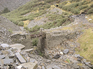
Coledale's most notable feature is Force Crag Mine; the buildings, spoil heap and associated structures of which are practically the only sign of human influence in the upper valley.
Mineral workings may date back to 1578 in the valley [3] Significant workings did not begin until the 1800s with lead and silver being mined until 1865, ending with a drop in the price of lead rendering it uneconomic. Later Barytes was mined, with 5300 tons of ore being produced up to 1879 when again market forces led to production ending. The mine was worked on and off with various changes in operation, and under different owners, [4] with lead, barium and zinc ores being extracted. In 1990 a collapse in the mine led to it being closed, and ownership passed to the National Trust. [3]
There were two workings of the mine, the low and high, and as of 2015 the mill of the mine [5] still stood. [6] The building is a Scheduled ancient monument and the mine is a site of special scientific interest. [7] The buildings can now be visited by appointment through the national trust.
As well as an aerial ropeway for transporting ore to the mill built in the late 1930s the mine also operated a small narrow gauge railway in the mine, utilising diesel and battery powered locomotives, one of which (Wingrove & Rogers Battery loco) is now at the Springfield Agricultural Railway, [8] three 2 ft gauge wagons from the mine are to be found at the Moseley museum in Redruth Cornwall. [9]

The Ravenglass and Eskdale Railway is a 15 in minimum gauge heritage railway in Cumbria, England. The 7-mile (11.3 km) line runs from Ravenglass to Dalegarth Station near Boot in the valley of Eskdale, in the Lake District. At Ravenglass the line ends at Ravenglass railway station on the Cumbrian Coast Line.
Crag Hill is a mountain in the North Western part of the English Lake District. It was formerly known as Eel Crag; however, the Ordnance Survey now marks Eel Crag as referring to the northern crags of the fell. It is not to be confused with another Crag Hill lying on the border of North Yorkshire.

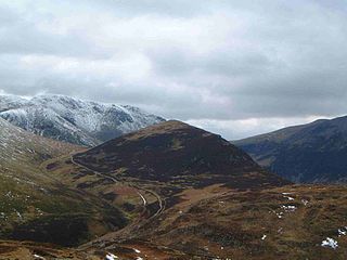
Causey Pike is a fell in the English Lake District. It is situated in the Newlands Valley, 5 km south-west of the town of Keswick. Even though it has a modest height of 637 metres (2,090 ft) it is one of the most distinctive fells when viewed from the Derwent Water and Keswick area due to its distinguishing summit "knobble" which catches the eye. The fell is one of 214 fells described by Alfred Wainwright in his series of Pictorial Guides to the Lakeland Fells: Causey Pike features in Book Six, The North Western Fells.

Above Derwent is a civil parish in the Borough of Allerdale in Cumbria, England. It lies entirely within the Lake District National Park.
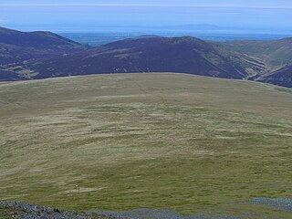
Mungrisdale Common, pronounced mun-grize-dl, with emphasis on grize, is a fell in the English Lake District. Although Alfred Wainwright listed it as one of the 214 featured hills in his influential Pictorial Guide to the Lakeland Fells it was his least favourite. He commented that it "has no more pretension to elegance than a pudding that has been sat on". There is some speculation that Wainwright included the fell in his guide simply as a way to fill space, but that has never been proven. Mungrisdale Common is oddly named, as it is a number of miles from the village of Mungrisdale, which lies in a different river catchment.

The Great Laxey Mine Railway was originally constructed to serve the Isle of Man's Great Laxey Mine, a lead mine located in Laxey. The 19 in gauge railway runs from the old mine entrance to the washing floors along a right of way that passes through the Isle of Man's only remaining railway tunnel under the 3 ft gauge Victorian Manx Electric Railway and the main A2 Douglas to Ramsey coast road.

Grisedale Pike is a fell in the Lake District, Cumbria, England, situated 4.5 miles (7.2 km) west of the town of Keswick in the north-western sector of the national park. At a height of 791 m (2593 feet) it is the 40th-highest Wainwright in the Lake District; it also qualifies as a Hewitt, Marilyn and Nuttall. Grisedale Pike presents a striking appearance when viewed from the east, particularly from the vicinity of Keswick. It possesses two subsidiary summits: one unnamed ; the other Hobcarton End.
Outerside is a fell in the Lake District in Cumbria, England. It is located 6 kilometres west of Keswick in the north western part of the national park and is a smaller member of the Coledale group of fells with a height of 568 metres (1863 feet). The fell is part of a ridge on the southern side of Coledale which descends from the higher fell of Scar Crags and continues over the neighbouring smaller fell of Barrow before reaching the valley at the village of Braithwaite.

The Newlands Valley is in the Lake District National Park in Cumbria, England. It is regarded as one of the most picturesque and quiet valleys in the national park, even though it is situated very close to the popular tourist town of Keswick and the busy A66 road.

Scar Crags is a fell in the north western part of the English Lake District in the county of Cumbria. It is one of the Coledale group of fells situated seven kilometres south west of Keswick and reaches a height of 672 metres (2205 feet).

Hopegill Head is a fell in the English Lake District in Cumbria. It is located nine kilometres west of the town of Keswick and is well seen from the B5292 road which crosses the Whinlatter Pass.

The Honister Slate Mine in Cumbria is the last working slate mine in England. Quarrying for Westmorland green slate has been taking place in the area since 1728. Apart from the mining it is also a popular tourist attraction in the Lake District National Park.

Sail is a hill in the English Lake District, lying between Derwentwater and Crummock Water.
The Rosedale Railway was an 19.5-mile (31.4 km) goods-only railway line running from Battersby Junction via Ingleby Incline, across the heights of the North York Moors in North Yorkshire, England to reach iron ore deposits in the remote hills of the Rosedale valley. It opened to traffic as a narrow gauge railway to Ingleby Incline top in 1858, converted to standard gauge and opened to Rosedale West in 1861, and closed completely in 1929. Apart from Ingleby Incline, no major engineering works were constructed, and as such, particularly the east branch, the railway followed the contours of the surrounding hillside. The former trackbeds of the railway are in use by walkers and cyclists.

Coledale Beck is a minor river running through Cumbria in England.
Some industrial narrow-gauge railways in the United Kingdom and the Isle of Man were primarily built to serve quarrying, mining, and similar industries. Some of these narrow-gauge railways offered passenger services for employees or workmen, but they did not run public passenger trains. They are listed by the primary industry they served.

Braithwaite is a village in the northern Lake District, in Cumbria, England. Historically in Cumberland, it lies just to the west of Keswick and to the east of the Grisedale Pike ridge, in the Borough of Allerdale. It forms part of the civil parish of Above Derwent.

Greenside Mine was a successful lead mine in the Lake District of England. Between 1825 and 1961 the mine produced 156,000 long tons of lead and 1,600,000 ounces of silver, from around 2 million tons of ore. During the 1940s it was the largest producer of lead ore in the UK. Unusually for a 19th-century metalliferous mine in Britain there are very full records of its activities, dating back to 1825.
The Eden Valley Railway (EVR) is a standard gauge heritage railway in Cumbria, England. It runs over a 2.2 miles (3.5 km) section of the original Eden Valley Railway in a north-westerly direction from the line's base at Warcop station. The line is run by the Eden Valley Railway Trust, formerly the Eden Valley Railway Society.

Grinkle Mine, was an ironstone mine working the main Cleveland Seam near to Roxby in North Yorkshire, England. Initially, the ironstone was mined specifically for the furnaces at the Palmer Shipbuilders in Jarrow on the River Tyne, but later, the mine became independent of Palmers. To enable the output from the mine to be exported, a 3-mile (4.8 km) narrow-gauge tramway was constructed that ran across three viaducts and through two tunnels to the harbour of Port Mulgrave, where ships would take the ore directly to Tyneside.