
Ascoli Piceno is a comune (municipality) and capital of the province of Ascoli Piceno, in the Marche region of Italy.
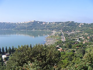
Castel Gandolfo, colloquially known as Castello in the Castelli Romani dialects, is a town located 25 km (16 mi) southeast of Rome, in the Italian region of Lazio. Situated on a hilltop in the Alban Hills with panoramic views of Lake Albano, Castel Gandolfo is home to approximately 8,900 residents and is renowned as one of Italy's most scenic towns. It is one of I Borghi più belli d'Italia.

The city of Rome, Italy, is divided into first-level administrative subdivisions.

Prima Porta is the 58th zona of Rome, identified by the initials Z. LVIII. The name Prima Porta came from an arch of the aqueduct that brought water to the Villa of Livia, which formed over Via Flaminia a sort of gateway which travellers saw as the first indication of having reached Rome (Piperno).
Monte Mario is the hill that rises in the north-west area of Rome (Italy), on the right bank of the Tiber, crossed by the Via Trionfale. It occupies part of Balduina, of the territory of Municipio Roma I, of Municipio Roma XIV and a small portion of Municipio Roma XV of Rome, thus including part of the Quarters Trionfale, Della Vittoria and Primavalle.

Folignano is a comune (municipality) in the Province of Ascoli Piceno in the Italian region Marche, located about 90 kilometres (56 mi) south of Ancona and about 6 kilometres (4 mi) southeast of Ascoli Piceno. As of 31 December 2004, it had a population of 9,214 and an area of 14.8 square kilometres (5.7 sq mi).
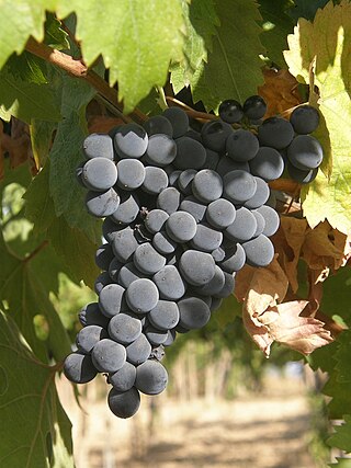
Montepulciano is a red Italian wine grape variety that is most noted for being the primary grape behind the DOCG wines Colline Teramane Montepulciano d'Abruzzo and Offida Rosso; and the DOC wines Montepulciano d'Abruzzo, Rosso Conero, and Rosso Piceno Superiore.

Torrenova is the 16th zona of Rome, identified by the initials Z. XVI. It belongs partly to the Municipio VI and partly to the Municipio VII.

Labaro is the 57th zona of Rome, identified by the initials Z. LVII. It is located 11 kilometres north of the city center, along the Via Flaminia, just outside the Grande Raccordo Anulare.

Settecamini is the 6th zona of Rome, identified by the initials Z. VI.. Settecamini is also the name of the urban zone 5L, within the Municipio V of Rome.

Ponte Galeria is the 41st zona of Rome, Italy, identified by the initials Z. XLI. Geographically it was part of Agro Romano. The zone belongs to the Municipio XI.

Via Cristoforo Colombo is a street in Rome (Italy) that links the historic centre to Ostia. Along most of its route, the street has three lanes for each direction of movement. With its 27 kilometres (17 mi) length it is the longest Italian road among those included within the borders of a single municipality and, in several stretches, the largest in Italy.
Monsampietro is a frazione (hamlet) of the comune (municipality) of Venarotta in the province of Ascoli Piceno in the Italian region Marche. The territory is part of Diocese of Ascoli Piceno.

Val Melaina is the 1st zona of Rome, identified by the initials Z. I, lying north of the city centre and covering an area of 6.2447 km².

Giuliano-Dalmata is the 31st quartiere of Rome, identified by the initials Q. XXXI. Its name refers to the Julian, Istrian and Dalmatian refugees that settled there in the postwar period.
Massimina is the urban zone 16E of Municipio XII of Rome. In a separate subdivision scheme, it belongs to zone "O" 20 A-B. Massimina is included in zone XLV Castel di Guido.

Strada statale 4 Via Salaria is an Italian state highway, linking Rome to the Adriatic sea passing through Rieti and Ascoli Piceno. Its route retraces that of the ancient Via Salaria Roman road. It is a single carriageway highway for most of its route.

Municipio Roma III is the third administrative subdivision of Rome (Italy).

Municipio Roma VII is the seventh administrative subdivision of the Municipality of Rome (Italy).

Castel Giubileo is the second Zone of Rome in the Ager Romanus, identified as Z. II.
This page is based on this
Wikipedia article Text is available under the
CC BY-SA 4.0 license; additional terms may apply.
Images, videos and audio are available under their respective licenses.
