
The Brisbane River is the longest river in South East Queensland, Australia, and flows through the city of Brisbane, before emptying into Moreton Bay on the Coral Sea. John Oxley, the first European to explore the river, named it after the Governor of New South Wales, Sir Thomas Brisbane in 1823. The penal colony of Moreton Bay later adopted the same name, eventually becoming the present city of Brisbane. The river is a tidal estuary and the water is brackish from its mouth through the majority of the Brisbane metropolitan area westward to the Mount Crosby Weir. The river is wide and navigable throughout the Brisbane metropolitan area.

The Victoria Bridge is a bus and pedestrian bridge over the Brisbane River. The current bridge, opened in 1969, is the third permanent crossing erected at this location. Since 24 January 2021, the bridge has been closed to general traffic, and now carries buses, pedestrians and cyclists only.

Albert Bridge is a heritage-listed railway bridge of steel truss design crossing the Brisbane River between Indooroopilly and Chelmer in the City of Brisbane, Queensland, Australia. It was designed by Henry Charles Stanley and built from 1894 to 1895 by John McCormick & Son as a replacement for an earlier bridge lost to flooding in 1893. Both bridges were named in honour of the Prince of Wales, Prince Albert. It was added to the Queensland Heritage Register on 21 October 1992.

Ipswich is an urban center within City of Ipswich in South East Queensland, Australia. Situated on the Bremer River, it is approximately 40 km west of the Brisbane central business district. Ipswich is renowned for its architectural, natural and cultural heritage, and the city preserves and operates from many of its historical buildings, with more than 6000 heritage-listed sites and over 500 parks. Ipswich was founded in 1827 as a mining settlement, and soon developed into a major commercial and population centre. The suburb of the same name serves as the city’s central business district. In the 2021 census, the population of the urban area of Ipswich was 115,913 people.

The Logan River is a perennial river in the Scenic Rim, Logan and Gold Coast local government areas of the South East region of Queensland, Australia. The 184-kilometre (114 mi)-long river is one of the dominant waterways in South East Queensland that drains the southern ranges of the Scenic Rim and empties into Moreton Bay after navigating the City of Logan, a major suburban centre located south of Brisbane. The catchment is dominated by urban and agricultural land use. Near the river mouth are mangrove forests and a number of aquaculture farms.

The Warrego Highway is located in southern Queensland, Australia. It connects coastal centres to the south western areas of the state, and is approximately 715 km in length. It takes its name from the Warrego River, which is the endpoint of the highway. The entire highway is part of the National Highway system linking Darwin and Brisbane: formerly National Highway 54, Queensland began to convert to the alphanumeric system much of Australia had adopted in the early-2000s and this road is now designated as National Highway A2.

Oxley is a south-western suburb in the City of Brisbane, Queensland, Australia. In the 2021 census, Oxley had a population of 9,100 people.

The Lockyer Valley is an area of rich farmlands that lies to the west of Brisbane, Queensland, Australia and east of Toowoomba. The Lockyer Valley is rated among the top ten most fertile farming areas in the world, and the intensively cultivated area grows the most diverse range of commercial fruit and vegetables of any area in Australia. The valley is referred to as "Australia's Salad Bowl" to describe the area as one of Australia's premium food bowls.

Indooroopilly is a riverside suburb 7.8 kilometres (4.8 mi) south-west of the Brisbane CBD, Queensland, Australia. In the 2021 census, Indooroopilly had a population of 13,622 people.

Karana Downs is a residential locality in the City of Brisbane, Queensland, Australia. In the 2021 census, Karana Downs had a population of 3,800 people.

Mount Crosby is a semi-rural outer western locality in the City of Brisbane, Queensland, Australia. In the 2021 census, Mount Crosby had a population of 1,860 people.
Moggill is a suburb in the City of Brisbane, Queensland, Australia. In the 2021 census, Moggill had a population of 5,029 people.

Kholo is a rural locality in the City of Brisbane, Queensland, Australia. In the 2021 census, Kholo had a population of 374 people.

Chuwar is a town and suburb of Ipswich in the City of Ipswich and a locality of the City of Brisbane in South East Queensland, Australia. In the 2021 census, the suburb of Chuwar had a population of 2,178 people.

Fernvale is a rural town and locality in the Somerset Region, Queensland, Australia. In the 2021 census, the locality of Fernvale had a population of 3,629 people.

Mount Crosby pumping station is a heritage-listed pumping station and weir at Stumers Road, Mount Crosby, City of Brisbane, Queensland, Australia. It is located on the Brisbane River and extends into Chuwar on the other side of the river. The facility supplies water to Brisbane and nearby cities and towns within the SEQ Water Grid. It was originally designed by Charles H McLay and built from 1891 to 1892. The historic parts of the facility were added to the Queensland Heritage Register on 25 October 2019. It is also listed on the Brisbane Heritage Register, together with numerous associated facilities which were not included in the state heritage listing.

The Somerset Region is a local government area located in the West Moreton region of South East Queensland, Australia, northwest of the City of Brisbane. The region is centred on the town of Esk, which also serves as the council seat. Somerset was created in 2008 from a merger of the shires of Esk and Kilcoy, and is known as the Brisbane Valley, owing to the Brisbane River which courses through the region. However, significant parts of the region lie outside the hydrological Brisbane Valley.
The Mount Crosby Weir is a heritage-listed weir on the Brisbane River at Mount Crosby and Chuwar, both in City of Brisbane, Queensland, Australia. The project was instigated by John Petrie at the end of the 19th century. The town of Brisbane was expanding and seeking more reliable sources of drinking water than Enoggera Dam and Gold Creek Dam could provide. In conjunction with the Mount Crosby Pumping Station, it was listed on the Queensland Heritage Register on 25 October 2019.

A series of floods hit Queensland, Australia, beginning in December 2010. The floods forced the evacuation of thousands of people from towns and cities. At least 90 towns and over 200,000 people were affected. Damage initially was estimated at A$1 billion before it was raised to $2.38 billion. The estimated reduction in Australia's GDP is about A$30 billion. As of March 2012, there were 33 deaths attributed to the floods, with a further three people still missing.

Biarra is a rural locality in the Somerset Region, Queensland, Australia. In the 2021 census, Biarra had a population of 270 people.


 An 1894 notice regarding the opening of the bridge crossing
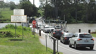
 College's Crossing under water in January 2012
